Page contents
- Consultation point – status of information
- Lens 2 description
- Potential number of homes and amount of employment land that might be delivered through this lens
- Places and sites explored in this lens
- How this lens performs against council priorities and plan objectives
- Severnside and the North Fringe large extensions
- Severnside and North Fringe small sites
- East Fringe large extensions
- East Fringe small extensions
- Summary of infrastructure challenges in this lens
- Lens map and site list
Consultation point – status of information
6b.1 In this consultation we are seeking your views on 3 alternative ‘lenses’ which have been explored to make choices as to where new homes, jobs and infrastructure might go. We are showing the places, individual sites, number of homes and amount of employment land which could have been delivered under each lens. Each lens represents a potential alternative approach to building a strategy to meet our needs for new homes and jobs, while balancing this against environmental, social and infrastructure issues.
6b.2 Please also read section 5. Towards an emerging preferred strategy. Although no decisions have been made at this stage, we have presented what we believe to be an appropriate preferred strategy based on what we know to date, influenced by the three lenses and sites within, presented in this consultation. The final strategy is yet to be determined and will be influenced by the further evidence we continue to gather, as well as your consultation comments on our emerging preferred strategy and each of the alternative lenses.
6b.3 This Urban Edge lens is not the final strategy. The sites we are showing and consulting with you on below are those we have explored through this lens. Further consultation and information is required to determine the most appropriate strategy to deliver homes, jobs and change in our new Local Plan. In technical planning speak at this point this strategy lens and potential site allocations carry very limited planning weight in the determination of planning applications and do not form the new adopted strategy for our Local Plan.
6b.4 Please read and review this lens, the sites and amount of new homes at each place suggested and let us know your thoughts. This will assist us in determining if the emerging preferred strategy has the most appropriate places and sites for a preferred strategy to deliver homes, jobs, services and infrastructure required in our new Local Plan.
Lens 2 description
6b.5 This lens would have focused our strategy for new jobs and homes on places and sites which surround the main urban areas, namely, the communities of the north and east fringes of Bristol and the Severnside employment area.
6b.6 Key factors that weighed in favour of this approach are that these existing urban areas contain jobs, services and facilities and a range of existing public transport connections and walking and cycling (active travel) routes, which reach into the city and outwards. This lens looked to make the most of existing and recent investments in infrastructure within and around the North Fringe, East Fringe and Severnside. National planning rules also support consideration of significant extensions to existing towns and villages where they are well located, designed and supported by necessary infrastructure and facilities, when large numbers of homes are needed.
6b.7 A range of sites exist at various scales which could have formed larger and smaller scale urban extensions immediately related and connected to the existing urban areas. There are several villages which are very closely related to the urban edge, with walking, cycling and public transport so also formed part of this lens.
6b.8 Some of the sites in this lens are likely to not require significant new infrastructure such as new roads, primary schools, flood defences, others would have required significant investment and interventions to deliver the homes and jobs needed within the plan period and to address site, community needs and development issues.
6b.9 All sites that formed part of this lens would require loss and change to the Green Belt to allow for development. There would be a need to understand the impact of removing any of these sites from the Green Belt and whether it would be possible to form long term defensible Green Belt boundaries. A separate evidence base is being developed to understand these issues in greater depth and will inform the final preferred strategy. Any sites taken forward to the emerging preferred strategy and the final version will need to provide evidence of how they create long term defensible Green Belt boundaries.
6b.10 This approach could have potentially supplied more homes than required to meet our minimum target. However, taking forward all sites in this lens would have likely led to significant impacts and challenges. These included building in areas of very high flood risk, impacting on heritage assets, strategic viewpoints and hillsides, damaging the connectivity of strategic green infrastructure corridors, maintaining the overall function of the Green Belt and setting new long-term Green Belt boundaries. There is also no certainty that the range of supporting infrastructure required for individual sites and overall combination of sites in this lens could be delivered or funded in the plan period. In particular; multiple motorway junction improvements and crossings, new bypass-roads, enhanced rail station and services, new strategic coastal flood defences, along with new primary, secondary schools and new public transport routes and infrastructure.
6b.11 At this stage to inform our emerging preferred strategy and to focus on exploring the issues involved with the sites and places in this lens, we consider it appropriate to focus on what might realistically be delivered in terms of homes, jobs and supporting infrastructure during our plan period to meet South Gloucestershire need for new homes and employment land. Following this consultation and with updated information on, sites, infrastructure and their delivery, further consideration on the potential for maximising the number of homes and jobs, or looking to meet unmet needs from adjoining authorities including Bristol City Council will be possible.
Potential number of homes and amount of employment land that might be delivered through this lens
6b.12 Based on the sites which have passed our initial assessment process, this strategy lens would have delivered:
- up to 12,750 new homes in the plan period and
- 44.5 ha of new employment land
6b.13 However, below we explored why we believe this is not deliverable over the plan period due to the delivery of infrastructure in a timely manner, impacts on the role and function of existing places as well as individual on site constraints and off-site impacts.
Places and sites explored in this lens
6b.14 This lens focused new homes and jobs around communities in close proximity to the communities of the north and east fringes of Bristol and the Severnside employment area, within South Gloucestershire. The lens also contained a number of smaller villages in the Green Belt that are considered to be in close enough proximity to Bristol and benefit from the services, facilities, jobs, very short public transport journey times and short walking and cycling access that already exists.
6b.15 When we explored each of these places a range of potentially suitable sites were available to deliver homes and jobs. We would like your views on whether these are the places that should grow and change to accommodate our needs for new homes and jobs rather than the sites presented in our emerging preferred strategy in section 5. We also would like your view on the sites at each place.
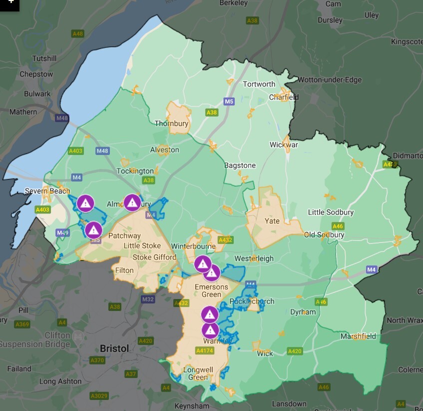
6b.16 Map showing the places where sites would have been explored if the Preferred Strategy focused growth towards the urban edges of Bristol.
6b.17 You can submit your comments on this lens and the potential site allocations in each place, through our interactive map.
6b.18 You can also check the potential site allocations at each place in this table.
6b.19 The places included in the urban edge lens can be found below. For each place we have also indicated the total number of potential sites and the potential number of homes and amount of employment land they could deliver in the plan period if they were taken forward into our Preferred Strategy.
6b.20 The potential to deliver can only be based on the information we have at this stage including information submitted by the promoter and our initial estimates on capacity and delivery set out in our Housing and Economic Land Availability Assessment (HELAA). These are subject to change as we start to gain more detailed information about each site, including their infrastructure needs. Some sites may continue to build out past the plan period and where this is likely an initial estimate of delivery after 2040 is also set out in this table.
How this lens performs against council priorities and plan objectives
6b.21 If this lens were progressed as our Preferred Strategy it would be able to deliver a large number of homes and jobs in proximity to the North and East fringe of Bristol as well as the employment area of Severnside taking advantage of the main service centres and employment centres across the district. It could also take advantage of the strategic infrastructure, public transport and active travel routes that support the large population centres and communities which the homes and jobs in this lens would be adjacent to. However, in doing so, the lens would present several challenges to align with our key objectives for delivering homes and jobs in a sustainable way. Challenges such as:
- delivering are large proportion of the planned need in the Green Belt
- planning for only a proportionate number of homes and jobs in rural villages which would not see any growth or the benefits that come with this including Affordable Housing and support for the rural economy
- the geographic balance of homes and jobs across the authority
- the ability to fund and deliver the strategic infrastructure needed particularly around the A4174 and provide significant enhancement to public transport networks across the places and sites in the lens
- the potential need to demonstrate that sites pass both the sequential and exceptions tests
6b.22 This lens would include a focus on larger sites with less sites in the small to medium range, which may cause issues for delivery of homes, jobs and necessary supporting infrastructure in the plan period. The range of infrastructure requirements on certain sites would create significant issues in maintaining a 5-year housing land supply over the early part of the plan period. Overall homes and jobs would be focused adjacent to the Bristol urban area where there is the potential for relatively good access to services, facilities and jobs and also enables more active lifestyles by taking advantage of the growing walking and cycling network within and around our urban areas.
6b.23 By focusing new homes and jobs in proximity to the urban edge this lens created strong potential to encourage more sustainable travel habits by reducing the potential need for longer distance travel and commuting across the Green Belt to access jobs and services. It is unlikely that everyone would work in the Bristol urban area at the three main centres of employment in the city centre, Avonmouth/Severnside and the North Fringe area of South Gloucestershire, however, these are still the main employment areas for the region and a significant number of people in South Gloucestershire already commute to them to access jobs. Therefore, it is assumed that this would continue to be the case.
6b.24 However, the sites in this lens are all located within the Green Belt. As government policy puts great importance on maintaining the Green Belt, alongside ensuring the homes we need are built, further work is required to understand the impact on the function of the overall Bath and Bristol Green Belt of releasing all or some of these sites, if they are taken forward as part of a Preferred Strategy. There would also need to be assessment of sites to understand where new long term defensible boundaries could be drawn, if some or all of the sites in this lens where to be released from the Green Belt to help address meeting housing need..
Severnside and the North Fringe large extensions
6b.25 These potential sites are located adjacent to the North Fringe of Bristol and the employment area at Severnside. They include strategic scale sites at Woodlands (L2-FC2) north of Easter Compton (L2-PSB9) with some smaller potential sites adjacent to these. They could deliver a large number of homes and at L2-PSB9 north of Easter Compton and (L2-PSB4) Severnside a moderate increase in employment land and jobs over the plan period. These places also support decarbonisation of travel across the district by locating homes close to the existing areas of employment, reducing the distance new residents will likely need to travel to jobs. Sites adjacent the Bristol North Fringe and around Severnside would need to provide new and enhanced public transport, walking and cycling routes to realise opportunities for sustainable and active travel, between the existing employment area at Severnside and North Fringe. Currently there are no large scale infrastructure connections or services from the proposed sites in this area. Below are the opportunities and challenges we identified when we explored this part of the lens and explains how we determined which places should feature in our emerging preferred strategy.
6b.26 Opportunities
- of the delivery of homes and jobs in proximity to the Bristol North Fringe and Severnside employment area including affordable housing close to main services centres and employment which would reduce the need for long travel journeys and decarbonise travel.
- Potential to better connect the Bristol North Fringe with Severnside with potential site locations in Easter Compton and north of Easter Compton (L2-PSB9) which could relieve pressure on the local network.
- The delivery of homes in proximity to the Severnside employment area would redress the current imbalance and potentially reduce the need to travel long distances across the district by allow people to co-locate where they work.
- to the delivery of homes and jobs here could also support the delivery of a sustainable, high quality and viable public transport offer and active travel routes that could better connect the Bristol North Fringe and Severnside.
6b.27 Challenges
- A number of sites are covered in part at Easter Compton or majority at L2-PSB9 Swanmoor Stoke by higher levels of flood zone and would require these sites to pass the Sequential and Exceptions tests. We do not currently believe we are in a position to justify the sequential tests as there are still opportunities within the lower levels of flood zone.
- It is likely that homes could not be delivered until these locations in higher flood risk areas could demonstrate they can be made safe over their lifetime (100years) without increasing flood risk elsewhere. This is unlikely to be possible without significant investment in flood defences, land raising and securing means of access and escape.
- A significant package of further evidence and technical work would be required to understand the cost of infrastructure and viability of development in this location especially with the inclusion of site that currently include high risk flood locations.
- Further evidence will be required to understand potential constraints on sites L2-PSB7 and L2-PSB1 in particular potential archaeological and heritage harm and how any development would respond to this.
- L2-FC2 (Woodlands Golf Course) would require strategic scale interventions to provide safe access onto the strategic and local road network, including a significant crossing of the M4 for people, public transport and cars, and it is currently unclear from the information provided how this will be achieved and funded in the plan period.
- L2-FC2 (Woodlands Golf Course has been identified as having a large area of onsite contamination due to past land uses and this is likely to incur further costs on development raising questions as to whether the site would provide all necessary supporting infrastructure, such as transport, primary school and local centre provision and maximise affordable housing provision.
- It is likely a solution will be required for the entrance to L2-FC2 Woodlands due to targeted higher flood zones at Trench Lane and Hortham Lane.
- A solution will be required for enhanced capacity at M5 motorway junctions 16 and 17 if all sites in this area were progressed as part of the preferred strategy,
- The combination of challenges highlighted above mean further evidence would likely be required to understand the sites viability and ability to deliver homes over the plan period.
Current approach to flood risk
6b.28 The potential site at L2-PSB9 north of Easter Compton (Swanmoor Stoke) also presented a number of challenges due to flood risk and the related issues of cost and delivery of infrastructure in a timely manner. The majority of the site is within the designated flood zone and based on the developer vision proposes residential, community and other uses in the highest zones of flood risks. It is unlikely that progressing this site as part of our preferred strategy would be acceptable against national planning policy. As it is clear that plan makers should follow the sequential test when deciding where to grow and avoid higher levels of flood risk when potential alternative sites exist in lower risk flood areas across South Gloucestershire, and these other sites could form part of a strategy. In a scenario where the plan was able to demonstrate that there were no suitable areas to deliver homes outside of the lowest risk flood zone area the sequential test could be engaged and then an exceptions test would also need to be passed. This would create a requirement for suitable flood defences to protect future residential and sensitive development such as community buildings and schools, over the life of the development (100 years). This would have been a significant infrastructure cost and there are currently no plans or designs for an enhanced flood defence scheme at Severnside, which created uncertainty for delivery in the 15 year plan period. The significant infrastructure cost of new flood defences would also need to be costed against other infrastructure requirements to bring this site forward as outlined by the promoter, namely, the opening of Pilning Station, land raising, a new bypass, as well as new services and facilities. It is not clear that these are deliverable or viable and would likely require significant public monies. This is unlikely therefore to have been an acceptable strategy to the council given it’s likely sufficient homes can be delivered in other areas of the district which do not put such reliance and dependency on the need to publicly fund essential infrastructure to make the developments sustainable.
What the sequential test is and when the exception test applies
6b.29 You can find out more about flood risk and plan making in the National Planning Policy Framework paragraphs 159 to 169.
6b.30 It was clear when we explored this lens that there were still sites and alternative lenses to explore in the areas of lower level flood risk and therefore it is suggested we do not include sites in higher risk levels of the flood zone. If, in later stages of the plan making process we are unable to meet housing needs in the lower risk flood areas then further consideration could be given to sites and locations adjacent Severnside in higher flood risk areas. This would come with the need for further evidence in the form of an updated Strategic Flood Risk Assessment 2. Further technical evidence would also be required to demonstrate the sites pass the exceptions tests which seeks to ensure the development would be safe for its lifetime (100 years) including factoring in climate change.
Sea defences
6b.31There are already a number of potential future flood defence schemes being brought forward in South Gloucestershire. Most notably the Avonmouth and Severnside Enterprise Area (ASEA) Ecology Mitigation and Flood Defence Project. This is currently under construction and is intended to support more jobs in the Avonmouth Severnside Enterprise Area. The ASEA scheme is upgrading existing defences along a 17 km stretch of coastline, including the defences from Severn Beach to Aust. Critically, it should be noted that the scheme is not intended to provide appropriate standards of protection for further residential development in the area and currently has a life span of 60 years.
6b.32 However, any major residential development and uses such as schools, community and health buildings would require a significant upgrade to the current flood defence scheme. And this would need to be fully costed and demonstrated to be deliverable before any sites could be considered for allocation. This creates a significant potential financial burden and risk to both developers promoting sites and the council. The current ASEA scheme is costing £80 million. It is therefore unlikely that any scheme could come forward in financial viability terms without significant public funding.
Pilning and Severn Beach Neighbourhood Plan
6b.33 The Pilning and Severn Beach Neighbourhood Area was designated on 11 January 2021 and the Steering Group continue to progress their draft plan. The council recognises the groups ambition to meet locally identified housing need and continues to support the group through our statutory advise and assist role. It is acknowledged that the area has some key constraints including higher flood risk and the Green Belt. Any plan would need to consider these in order to demonstrate they are able to meet the locally identified need in a way that fully mitigates these constraints, including through demonstrating sites have passed the sequential and exceptions tests.
100% employment sites
6b.34 Some sites in proximity to Severnside and Pilning are currently promoted for 100% employment use and although in the higher risk flood zones they are considered to be less vulnerable uses under the Government’s planning rules. The current ASEA defences as outlined above are also designed to provide the appropriate level of protection for these types of use.
Severnside and North Fringe small sites
6b.35 There are also smaller sites in this part of the lens at Hallen, Almondsbury, Frenchay and Hambrook which could contribute to the homes and jobs needed over the plan period. They too could take advantage of existing services and facilitates due to their relative proximity to the Bristol urban area. These sites could also play a role in providing for a proportionate deliverable number of homes and jobs, including affordable housing in some of the smaller rural settlements adjacent to the urban edge. Below are the opportunities and challenges we identified when we explored this part of the lens and explains how we determined which places should feature in our emerging preferred strategy.
6b.36 Opportunities
- The delivery of these smaller sites would protect the 5-year housing land supply particularly in the first five years of the plan, protecting communities from speculative development.
- Development at these locations would provide affordable housing in area where affordability is an issue allowing local people to stay within their communities.
- Development at these locations can support the continued vitality of good public transport connections and active travel routes into Bristol to access services and facilities including jobs.
6b.37 Challenges
- There would be concerns regarding the capacity of health services in the Severnvale area. This is demonstrated by data from the NHS Integrated Care Board which shows that the Severnvale Primary Care Network, which includes GP surgeries at Thornbury, Almondsbury and Pilning is the highest priority for investment in South Gloucestershire. A solution would be required if homes were to be delivered in this part of the district.
- A solution would be required for primary school education due to capacity at Almondsbury.
- Growth at Hallen would also require a solution for education as there is no primary/secondary education provision within Hallen and also no safe walking and cycling route to the nearest locations.
- Some sites are partly covered by higher flood risk and these would have to demonstrate they could pass the sequential and exceptions tests as explained earlier in this section.
- The development of some sites around Hambrook and Frenchay may pose a challenge to the longer term function of the Green Belt corridor into Bristol and further consideration and evidence would be required to understand how developing sites in this area would impact the function of Green Belt within Bristol and South Gloucestershire inside of the M4 Motorway in this area.
- Some sites in Hambrook have potential for significant impacts and harm to heritage assets and in particular the rural setting of the Hambrook Conservation Area.
East Fringe large extensions
6b.38 There are a number of larger sites explored under this lens and these are located adjacent to or in proximity to the East Fringe of Bristol. These included sites at Pucklechurch West, north of Lyde Green, Shortwood South and Warmley which could have delivered a large number of homes and jobs including a substantial amount of new affordable housing. By locating larger urban extensions close to the East Fringe of Bristol these new communities could access services, facilities and jobs at town centres such as Emersons Green, Downend, Staple Hill, Kingswood and Hanham as well as the Science Park and further. Delivering homes and jobs here could also reduce the need for long travel distances across the district, particularly across the open countryside and Green Belt. Not only could this potentially reduce travel times but there is also potential that these places could more easily connect into and enhance existing public transport or active travel routes thereby providing alternative transport options to the private car. This is the reverse of the No Green Belt lens which would likely require longer travel times across the district to access the main service centres in the district and the main service centre in the region. Below are the opportunities and challenges we identified when we explored this part of the lens and explains how we determined which places should feature in our emerging preferred strategy.
6b.39 Opportunities
- Could deliver a large number of homes to meet the plan needs including a large number of affordable homes.
- A number of site promotions proposed to deliver a significant amount of employment land which could support the rebalancing of jobs in the East Fringe of Bristol including Shortwood (L2-BV9) includes the provision of 8.5 hectares of new employment land and north of Lyde Green (L2-BV15) includes 16.1 hectares of new employment land.
- The Core Strategy supported by 2011 census data showed an imbalance in jobs and homes in this area of the district. This creates a reliance on other areas of the district for work opportunities so creating a higher need for travel and private car use.
- Although it is unlikely that everyone will work and live in their immediate community the provision of jobs within walking and cycling distance allows the potential for people to reduce the cost of commuting and its impacts on inequality, reduce private car journeys and decarbonise travel.
- There are a number of opportunities along the East Fringe for development to create and enhance access from the urban area into the countryside by protecting and connecting existing green infrastructure assets such as woodland and common land. The potential sites at Pucklechurch, Shortwood and Warmley all have the potential to support with funding and master planning the connectivity of local biodiversity.
6b.40 Challenges
- It is unclear whether, or to what scale, this level of employment provision will genuinely support the rebalancing of homes and jobs and further work is needed to understand this. These potential sites are some of the few to date that provide any substantial employment offer.
- Some larger site promotions do not offer any significant employment opportunities including those at Pucklechurch (L2-BV2) and Warmley South (L2-BV10) which will reinforce the current negative trend and imbalance of jobs and homes.
- Delivering homes and jobs at the East Fringe particularly at Shortwood, Warmley and Pucklechurch will need to be designed carefully taking account of the landscape sensitivities as well as the conservation areas of Siston and Pucklechurch and the important views and settings between them.
- This level of development would create challenges in delivery of the infrastructure necessary to accommodate this number of homes and jobs and it is unlikely that the infrastructure could be in place to allow the homes to be delivered in the plan period.
- The level of growth would likely put significant pressure onto existing local and strategic road network (for example key arterial routes into Bristol (i.e. A432, A420) as well as known network pinch points such as the Bromley Heath Roundabout and Willy Wicket Roundabout.
- There would need to be a suitable primary school and secondary school solution for this level of growth focused in this part of the district and it is unclear how that could be delivered.
- There is further work to do to understand what how many homes may be appropriate to benefit from existing infrastructure whilst also being of a sufficient scale to be able to contribute to infrastructure needs including an attractive, financially viable public transport offer capable of attracting trips away from private car.
- New long term Green Belt boundaries will need to be created, to maintain the overall function of the Green. If any or all of the sites are taken forward as part of the preferred strategy there will be a need to avoid long-term coalescence with surrounding villages and merger of the greater Bristol urban area with Bath, particularly in and around the Hanham and Willsbridge area, and prevent future unrestricted sprawl of potential sites between Oldland, Shortwood, Pucklechurch and Westerleigh into the wider countryside.
East Fringe small extensions
6b.41 This area of the lens features a number of places that could deliver ‘smaller’ scale urban extensions of a few hundred homes each adjacent to the East Fringe at Hanham, Willsbridge, Oldland Common, Bridgeyate, Mangotsfield and Shortwood North. These locations are located adjacent to the urban area which means they can also take advantage of existing services, facilities, in nearby town and local centres. Some such as Mangotsfield are in close proximity to a local centres and Staple Hill Town Centre. Sites at Bridgeyate, Mangotsfield and Shortwood North would need to take opportunity to link into existing cycle routes to the Emersons Enterprise area. All sites currently have access to public transport access to local and wider employment and retail facilities. These locations also provide the opportunity to connect to and enhance the viability of existing public transport and active travel routes potentially reducing the number of private car journeys further decarbonising travel. Below are the opportunities and challenges we identified when we explored this part of the lens and explains how we determined which places should feature in our emerging preferred strategy.
6b.42 Opportunities
- These developments sites would likely require no major infrastructure and so could deliver in the early years of the plan period. This would protect the 5-year housing land supply and portfolio of sites to deliver affordable and new homes in the plan period.
- Smaller developments with reduced need to deliver costly supporting infrastructure could deliver a higher portion of affordable homes.
- Diversify the range of site sizes included in our new Local Plan.
6b.43 Challenges
- New long term defensible Green Belt boundaries would need to be created, while also connecting into and where possible enhancing the remaining area of Green Belt.
- These smaller locations do not offer any significant employment offer and therefore would not help address the imbalance of jobs and homes in this part of the district.
- Maintaining and enhancing the function and connectivity of Strategic Green Infrastructure Corridor F and D, in which the sites are located. This would need to be achieved through careful consideration of suitable on site GI, placement of development and providing new connections, habitats and landscapes to the existing corridors.
- A greater understanding and potential mitigation, in relation to the cumulative impact of all smaller scale urban extensions being progressed as part of a preferred strategy on education and health facilities.
Summary of infrastructure challenges in this lens
6b.44 This lens has explored on a number of key infrastructure challenges based on what we currently know and a summary of these can be found below. Further work would be needed to understand the scale of the impacts and exactly what infrastructure would be required and how this could be funded and delivered in a timely manner if these sites were to feature in the preferred strategy. Where sites have been included in our current section 4 Towards a Preferred Spatial Strategy, work is ongoing to understand and resolve these challenges. Your feedback and additional evidence will support any final decision.
North Fringe
- New flood defences with appropriate level of protection for residential development would be required to be planned, funded and delivered in the plan period.
- An expanded train station, with significant increased service at Pilning station would be required to support significant growth at the Severnside, Swanmoor Stoke site, this would need to be deliverable and fundable in the plan period.
- New public transport and active travel infrastructure to better connect Severnside to potential site at Swanmoor Stoke and into the North Fringe would be required in the plan period.
- M5 junctions 16 and 17 will require solutions which are deliverable and fundable in the plan period.
- A new or significantly enhanced motorway crossing would be required to connect proposed site at Woodlands into existing residential area of Bradley Stoke, if it were taken forward as part of the preferred strategy.
- New health, primary, secondary and playing pitch provision will be required at these locations. These currently have no funding or certain proposals.
- Health and education pressures at a range of rural villages will need to be further explored and solutions found, particularly in and around Severnside, and Almondsbury where facilities are considered to be approaching capacity and in the case of Easter Compton currently lacking a school and GP surgery.
East Fringe
- Additional traffic pressure on the existing road network around and into Bristol, particularly on the A4174 and routes into Bristol through Downend, Staple Hill and Kingswood, which will need solutions within the plan period.
- Attractive public transport solutions will need to be explored to connect new communities to each other and orbitally via the A4174.
- Extension and enhancement of existing active travel routes alongside the A4714, connecting into and expanding the Bristol to Bath cycle routes, along with enhanced walking and cycle connections into Bristol and to Yate from the East Fringe.
- New health, primary, secondary and playing pitch provision will be required to support strategic growth sites and cumulative impact of smaller scale growth at Hanham, Oldland, Mangotsfield and Shortwood.
- The sensitive ecology, green infrastructure and heritage of the east fringe in and around Shortwood, Siston and Warmley will require suitable buffering, and significant green infrastructure corridors to ensure existing green assets, key active travel routes and areas of woodland are not isolated from each other and the wider countryside. Some assets and connections would be impacted significantly if all larger sites in the East Fringe to be taken forward into the Preferred Strategy.
Lens map and site list
6b.45 You can submit your comments on this lens and the potential site allocations in each place, through our interactive map.
6b.46 Alternatively you can view the sites in Appendix 1 and Appendix 2.
Question
Do you have any comments on the Urban Edge strategy lens?
Send us your feedback by completing the questionnaire on our consultation page.
Please submit your comments on individual sites, through our interactive map. You can also provide comments on the overall lens on the map.
Read the next section – Strategy Lens 3: Transport corridors and hubs.
Or return to the contents page.