Page contents
- Our emerging strategy
- The key drivers informing our emerging preferred strategy
- Why we need to amend the Green Belt
- Future transport infrastructure considerations
- Places currently included in the emerging preferred strategy
- Further work and investigations
- Green Belt exceptional circumstances and boundary review
- Settlement boundary amendments
- Transport and infrastructure emerging evidence and next steps
Our emerging strategy
5.1 In this section we want to share the council’s emerging thoughts on what we think the ‘preferred strategy’ for homes, jobs, change and protection is starting to look like.
5.2 This Emerging Preferred Strategy is the first time we have shared how we intend to approach the challenge of selecting the locations for future housing and employment development. There is still more work to do, including taking account of the views expressed through the consultation process and considering further evidence.
5.3 Based on the technical work we have undertaken so far, we think at least 7,813 new homes will need to be on greenfield land that is beyond the urban area and market towns, some of which is currently designated Green Belt.
5.4 We know this will be very challenging for those communities affected by this.
To understand why we need to deliver these homes and jobs on greenfield land section 3a explains how many homes we need and our approach to affordable homes.
We also want to deliver new employment land over the 15 year plan period to achieve our key objectives to rebalance the district and ensure communities can access jobs close to where they live. Section 3b explains the target and locational issues with existing and future land for employment.
Section 4 sets out how many homes will be delivered within our urban areas and market towns as a first step in our new strategy.
5.5 At this stage it is important all stakeholders are clear that although the council is indicating an emerging preferred strategy, no final decisions on the places, sites and level of growth overall or for each specific place have been made.
5.6 We are setting out this emerging preferred strategy to help bring focus to the consultation and this is not the final position.
5.7 Moreover, given the fact that some sites have been identified and others have not, this does not mean individual sites shown in this section can be given any weight and status in the assessment of planning applications coming before the council at this stage.
The key drivers informing our emerging preferred strategy
5.8 Key drivers respond to national policy, in particular the National Planning Policy Framework and National Planning Policy Guidance. They also respond to Local Plan and council objectives set out in Section 3 under the headings below:
- New homes for all communities
- Travel and transport
- Climate, nature and heritage
- Design and place-making
- Jobs and businesses
- Deliverability and viability
5.9 The emerging preferred strategy for South Gloucestershire in summary, seeks to locate development where it can contribute to reducing the impacts of, and on climate change, for example by reducing the need for cross Green Belt commuting and supporting the commitment for decarbonising travel. It focuses on directing a significant element of the new development close to the urban edge of greater Bristol, utilising suitable sites in greater proximity to existing jobs, public transport routes, capitalising upon existing facilities and infrastructure. Where possible, we have tried to avoid taking forward sites that, based on current information from promoters and our partners, would require challenging and costly infrastructure, with no certainty of delivery in the plan period. However, we recognise a strategy for new homes and jobs will need a range of new and enhanced infrastructure, and where this is likely, this has been identified below. We have also sought to improve the sustainability of our smaller places, where new development can also help to strengthen their vitality.
5.10 We fully understand that where homes and jobs are delivered this will result in change for many communities. However, there is no preferred strategy that can avoid this. Our choices of which places and sites are appropriate to progress into an emerging preferred strategy have sought to minimise site specific harm, for example to heritage or natural environment assets and other onsite constraints. Whatever the final strategy looks like, things will look different. This will mean some local areas and currently undeveloped fields will in future have affordable homes, new spaces for employment and local services on them. However, wherever possible in choosing the sites we have sought to avoid harming the most important assets and avoid sites where no mitigation or evidence for dealing with harm has been put forward by site promoters.
Why we need to amend the Green Belt
5.11 We do not think an appropriate strategy can be formed by meeting our needs for new homes and jobs on sites beyond the Green Belt. We have explored and shown through Lens 1, what avoiding any loss of Green Belt would look like and found it would likely cause overloading of villages, settlements and locations with poor infrastructure, and significant growth in places with relatively poor services, facilities and opportunities for sustainable travel.
5.12 Where potential allocation sites in the emerging preferred strategy are located in the Green Belt this will result in changes to the overall extent of Green Belt in South Gloucestershire. Work is currently underway to understand the contribution of the potential sites to the five purposes of the Green Belt and how harmful their removal might be. The council and promoter will also need to work closely to understand how a new strong defensible boundary can be achieved that will endure beyond the plan period. Site promoters will also need to consider and plan for the remaining Green Belt land to be improved and enhanced to provide high quality open spaces and support our green infrastructure and nature recovery objectives.
Future transport infrastructure considerations
5.13 The emerging preferred strategy has been informed by principles for how we intend to deliver transport infrastructure in future. This will help meet our plan objectives and ensure we can continue to encourage decarbonisation of travel and promote alternative sustainable travel alternatives to the private car.
5.14 Although details on specific interventions will need to be explored further, we are seeking to locate homes and jobs in locations that lend themselves to supporting our objectives. When making choices about where homes and jobs should be located, the emerging preferred strategy has, where possible, been influenced by the following principles:
- Locate homes and jobs in places that reduce the likelihood of long travel commutes.
- Locate homes and jobs in places where active travel connections already exist, can readily be enhanced, or new connections can be delivered and provide an attractive alternative to private car travel.
- Locate homes and jobs in locations that are on existing public transport routes or could be capable of delivering high-quality, viable and reliable public transport services in future.
- Locate homes and jobs in places that avoid, where possible, a high reliance on private car-based travel or costly infrastructure packages that are unlikely to be delivered in the plan period.
5.15 By choosing an emerging preferred strategy that follows these principles we are able to encourage alternative and more sustainable travel, reduce travel distances and prevent building commuter towns that rely on long distance travel to access jobs, services and facilities.
5.16 In arriving at our emerging preferred strategy some places and sites, although meeting the principles above would have created conflict with other key objectives and considerations, for example avoiding significant harm to heritage assets, developing on key landscapes, hillsides or strategic views, even though they were located near a transport corridor. The sites and places we set out in this section have needed to strike a balance between being sustainably connected and located whilst also avoiding significant conflict with our other objectives.
5.17 It is important to note that the delivery of proportionate homes in our rural communities, including the delivery of affordable homes, may not lend themselves to these principles, however, in keeping the delivery of homes and jobs in these communities proportionate, we are able to support rural communities and the rural economy whilst keeping adverse impacts to a minimum.
5.18 When considering our emerging preferred strategy, it is important that places and sites are considered alongside the likely infrastructure that will be needed to support the homes and jobs. This could include the delivery of train stations, roads, flood defences, changes to motorway junctions, new schools or expanded school capacity, playing pitches and new areas for biodiversity and green infrastructure.
5.19 A key factor which has influenced the choices we have made is that sites that require supporting infrastructure will need to demonstrate they can deliver this over the 15-year Local Plan period that ends in 2040. Sites which would require infrastructure that currently have no demonstrable pathway, support from key stakeholders, national bodies or funding routes creates huge risk to communities, the council budgets and long-term creation of high quality, sustainable places. Where sites are predicated on the delivery of large infrastructure projects, where public funding has not been agreed or looks currently not capable of being agreed, this will also present a risk to the delivery of new housing and employment. It will also make it more challenging to ensure the council is fully policy compliant with the level of Affordable Housing provided.
5.20 Where larger sites are currently included in the emerging preferred strategy further work will be needed from the council and those promoting sites as to how this infrastructure is intended to be costed and delivered. How will new crossings over motorways be funded, delivered and provided? How will new or expanded schools be funded? We will expect developers to clearly evidence how they will support and plan for new supporting infrastructure to come forward before or alongside the homes and jobs and particularly further details on how this will be phased during our 15-year plan period. This will be vital if the council is to demonstrate and protect a 5-year housing land supply over the full plan period.
5.21 In considering homes and jobs to support our smaller communities it has been important to recognise that this will need to be proportionate to the available level of services and facilities and public transport connections available. A key driver has been the predicted number of available primary education places in existing local schools matching the proposed level of growth in a village. A small number of homes will not be able to fully fund sustainable expansions to existing or provide new schools and therefore the proportionate number of homes has been influenced by existing school capacities. In particular, this has influenced the number of homes considered proportionate at Alveston, Olveston, Cromhall, Rangeworthy, Hawksbury Upton and Acton Turville. As part of this consultation, we have multiple potential sites in some of these villages where only one is required. We are asking for your thoughts on which site should be progressed at Alveston, Cromhall, Rangeworthy and Acton Turville. In some cases, the absence of any primary school provision and unsuitable walking and cycling or public transport access has meant no homes are considered proportionate or sustainable. This is the case at Hallen, Tytherington and Tockington.
Places currently included in the emerging preferred strategy
5.22 The chart below shows the distribution of where the emerging preferred strategy would deliver the full standard method of 20,490 new homes across the district over the plan period. This includes commitments previously allocated or speculative development given planning permission, small site windfalls and our proposed new urban and green field site allocations.
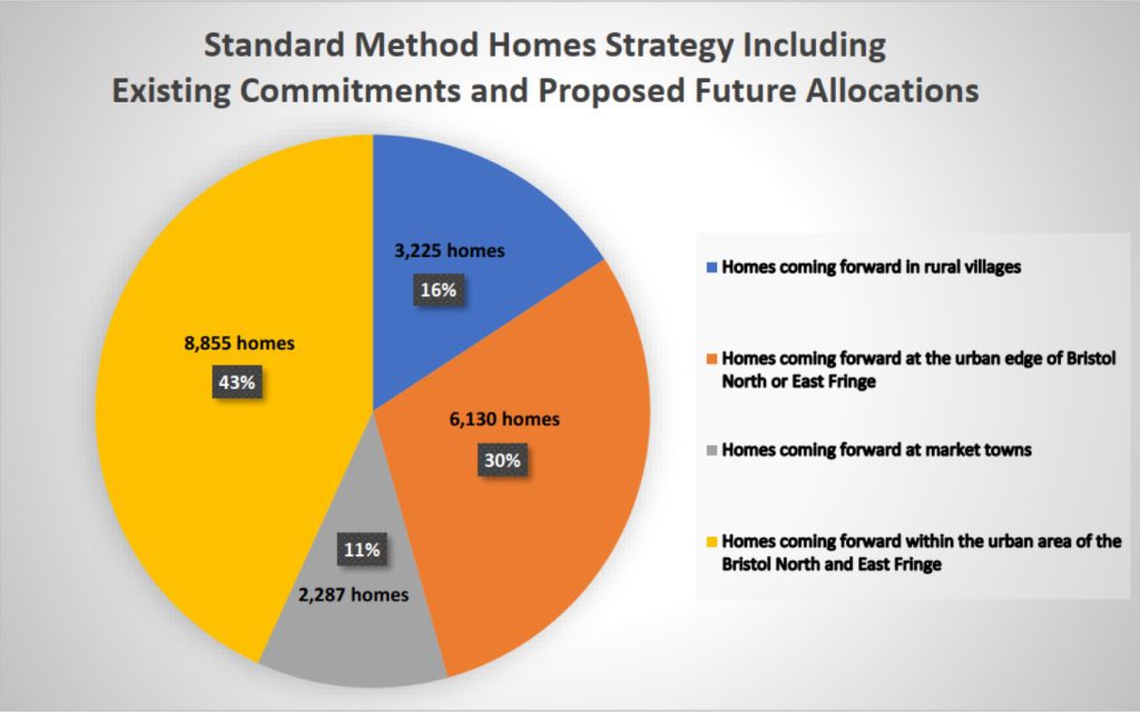
5.23 Our emerging preferred strategy includes the delivery of new homes and jobs from existing committed developments, small site windfalls and new allocations within the urban boundaries or the North and East Fringes of Bristol as well as within our Market Towns of Yate and Thornbury. It does also require homes and jobs to be allocated on new green field allocations.
5.24 Although we are only consulting on new site allocations, each category will play an important and significant role in helping us meet our need for homes and jobs over the plan period.
Existing commitments
5.25 The commitments already in place include sites allocated in previous Local Plans and sites which have been granted planning permission, that will deliver new homes between 2025 and 2040. We are not consulting on any committed sites as these already have planning permission. 10,837 new homes will be delivered from this source over the next 15 years.
Small site windfalls
5.26 Small site windfalls include the delivery of homes and jobs on sites which are too small to allocate but which come forward over time predominantly through infilling and redevelopment opportunities in existing settlements. Historically we have been able to demonstrate a yearly supply of 210 new homes per year from this source and these are included in the commitments. However, we have reviewed the rate of past completions on these sites and consider we can justify a 20 homes per year uplift, bringing this to 230 per year. In total it is estimated that 300 additional homes will be delivered by this uplift in small site windfalls.
Where can I find out more about new allocations within urban areas and market towns?
5.27 For more information on new allocations within the urban areas and market towns please read section 4.
Table of places in the emerging preferred strategy
5.28 The tables below set out how we are seeking to deliver the homes and jobs we need.
| Category | Number of sites at this place | Potential Housing Capacity in plan period (Total site capacity) |
|---|---|---|
| Commitments Includes large sites (10 homes and over) allocated in previous plans and sites granted planning permission. Includes small site windfalls (1-9 homes). For further information read section 3a. | N/A | 10,837 |
| Small site windfall uplift Additional homes we believe we can get from small sites. For further information read section 3a. | N/A | 300 |
| Urban and market town allocations New urban allocations in our urban areas of the Bristol East and North Fringe, and in Yate and Thornbury. For further information read section 4 | N/A | 1,540 |
.
| Category | Number of sites for consultation at this place | Potential Housing Capacity in plan period (Total site capacity shown in brackets) | Potential Employment Land |
|---|---|---|---|
| New Green Field Allocations – Urban Edge | |||
| Almondsbury | 3 | 410 | 1.1ha Light industrial |
| Bridge Yate | 1 | 110 | 575sqm Industrial/ Distribution |
| Easter Compton | 4 | 450 | |
| Hanham West | 3 | 270 | |
| Mangotsfield | 2 | 260 | |
| North of Lyde Green | 1 | 800 (2,000) | 16.1ha Mixed Employment |
| Oldland Common | 1 | 350 | |
| Shortwood North | 1 | 280 | |
| Shortwood South | 3 | 1,150 (2,500) | 8.53ha Industrial/ Distribution 1.76ha Mixed Employment |
| Warmley North | 2 | 1000 | 595sqm Office/ Research |
| Willsbridge | 2 | 110 | |
| Woodlands | 3 | 800 (2,045) | |
| Total number of new homes from this category | 5,990 |
.
| Category | Number of sites for consultation at this place | Potential Housing Capacity in plan period (beyond plan period) | Potential Employment Land |
|---|---|---|---|
| New Green Field Allocations – Market Towns | |||
| Thornbury – North and East | 1 | 15 | |
| Thornbury South | 1 | 40 | |
| Yate West – North | 1 | 20 | |
| Total number of new homes from this category | 75 |
.
For the full contribution that the Market Towns will make to delivering our housing need read Growth around our market towns – Yate, Chipping Sodbury and Thornbury below.
| Category | Number of sites for consultation at this place | Potential Housing Capacity in plan period (beyond plan period) | Potential Employment Land |
|---|---|---|---|
| New Green Field Allocations – Rural Communities | |||
| Acton Turville | 3 | 25 | 3ha Mixed Employment |
| Alveston | 5 | 100 | |
| Badminton | 1 | 0 | 0.82ha Mixed Employment |
| Charfield | 2 | 775 | |
| Coalpit Heath | 1 | 90 | |
| Cromhall | 7 | 30 | 350sqm Office/ Research/ Light Industrial |
| Engine Common | 4 | 90 | |
| Frampton Cotterell | 1 | 60 | |
| Hawkesbury Upton | 1 | 20 | |
| Hortham | 2 | 100 | |
| Marshfield | 1 | 50 | |
| Olveston | 1 | 20 | |
| Pilning | 1 | 0 | 13.6ha Mixed Employment |
| Pucklechurch | 1 | 60 | |
| Rangeworthy | 5 | 30 | |
| Tytherington | 1 | 0 | Hotel and Leisure |
| Wick | 4 | 70 | 500sqm Office/ Research/ Light Industrial |
| Winterbourne | 3 | 235 | |
| Total number of new homes from this category | 1755 | ||
| Emerging Preferred Strategy New Homes Proposed | 7820 – in 15 year plan period 3,795 – beyond plan period |
5.29 You can view and comment on all of the sites within our emerging preferred strategy by going to our interactive map.
5.30 Alternatively, you can view the basic site schedule in Appendix 1 or the detailed site information in Appendix 2.
5.31 Each site has been given a unique site code which it will be important to reference when commenting on a specific site. The code will always start with EPS (emerging preferred strategy) followed by initials for the ward it is located in and its number. For example EPS-CHAR1. Where we make reference to places below we have also highlighted in bold the site code so you can make a note and look at this on the interactive map or site schedule below.
Site boundaries and estimated capacities within and beyond the plan period
5.32 For each place we have indicated the total number of potential sites and the potential number of homes and amount of employment land they could deliver in the plan period if they were taken forward into our Preferred Strategy. This, in some cases, indicates that only part of a site will be developed in the plan period up to 2040. The remainder being delivered thereafter. Total site capacity is shown in brackets in the table above. Work is ongoing to understand the phasing and delivery of infrastructure to support this.
5.33 The potential to deliver can only be based on the information we have at this stage including information submitted by the promoter and our initial estimates on capacity and delivery set out in our Housing and Economic Land Availability Assessment (HELAA). These capacity estimates are subject to change as we start to gain more detailed information about each site, including their infrastructure needs. For instance, it is critical that we make the most efficient use of land possible whilst respecting local character, site constraints and ensuring high quality placemaking. We are therefore particularly interested in pursuing more ‘compact’ forms of development as promoted in the National Design Guide, which may challenge developer’s usual assumptions in respect of density and house types.
5.34 During our assessment we have revised site boundaries to better reflect local and on site constraints. Therefore, sites presented as part of the emerging preferred strategy may not reflect the site boundaries as submitted by the promoter or shown on the online Call for Sites Map. We would therefore encourage you to view the interactive map to ensure you are viewing the correct site boundary.
Urban areas and market towns
5.35 National policy is clear that in forming a strategy to deliver homes and jobs local plans should make as much use as possible of suitable brownfield sites and underutilised land. Further information on our approach to this can be found in Section 4 which explains how we have identified enough sites to deliver 1,540 new homes in our urban areas. These new site allocations will supplement existing commitments, as well as ongoing small scale windfall developments and demonstrate that we are seeking to allocate all reasonably suitable and certain sites within our urban areas and market towns. We are also creating a policy framework to make the most effective use of land that will facilitate future regeneration and provision of more homes and jobs when opportunities come forward.
Urban edge of the Bristol East Fringe
5.36 Our emerging preferred strategy would look to place urban extensions, both large and small adjacent to the East Fringe of the urban area of greater Bristol. These new communities will be able to take advantage of the opportunities to be accessed by and access sustainable travel modes, services, facilities and jobs at town centres such as Emersons Green, Downend, Staple Hill, Kingswood, Hanham plus the existing jobs at the Science Park. By locating homes and jobs here the emerging preferred strategy can reduce the need for long travel distances across the district. The large proposed sites at Lyde Green North, (EPS-BV13), Shortwood Golf Course (EPS-BV9), and North Warmley (EPS-BV14), all include a level of services and facilities, including a local centre, education facilities and new recreation, open space and green infrastructure. It will be important that a level of self-containment and on the door-step facilities are available on these sites.
5.37 Provision of further employment land is an important consideration for the entire strategy but also for any significant allocation of new homes in the East Fringe. The East Fringe of Bristol is identified as having a homes-to-jobs imbalance, and areas of employment deprivation in some of the more deprived urban communities in the East Fringe was a significant issue in the 2011 Core Strategy plan-making. There are only 0.4 close proximity jobs per person in the East Fringe, compared to 1.8 for the North Fringe (Filton, Bradley Stoke, Stoke Gifford, Little Stoke, etc.) based on 2011 Census Table WF01BEW. This issue has been made worse by loss of employment land including speculative development on our safeguarded employment sites within the East Fringe of Bristol in recent years.
5.38 This Emerging Preferred Strategy has the potential to address some of that imbalance. The provision of new employment land in the East Fringe through our emerging preferred strategy could help to reduce the impact of this imbalance and reduce longer commuting distances for new communities.
5.39 This area also offers opportunities to connect and enhance to existing infrastructure and public transport community hubs, including the metrobus connections from Bristol to Lyde Green, Bristol and Bath Railway Path and active travel routes adjacent the A4174 ring road. This will help to prevent unnecessary journeys across the Green Belt, recognising that the majority of travel for work will be into Bristol and the North Fringe as key urban centres for employment opportunities. It also has the potential to make providing services such as social care and school transport more efficient by reducing travel distances.
5.40 Large scale, mixed use urban extensions in this locality are proposed at land North of Lyde Green (EPS-BV13), which would include a significant element of employment floorspace in their site promotion. This proposed mixed use allocation would include a significant element of new employment land that would complement and build on the continued success at the Bristol and Bath Science Park, while increasing the range and type of employment land accessible for communities of the East Fringe. This additional employment land, as well as the potential recreation and leisure uses proposed on this site, would help meet demand for space from national and regional employers and employment sectors that have locational needs relating to the success of the Bristol and Bath Science Park and provide land for new grow on spaces for companies which start there.
Shortwood Golf Course (EPS-BV9), Glenfern and Land to East of Carsons Road (EPS-BV10) and North Warmley (EPS-BV14), are site promotions that include provision for new employment land and floorspace. This is more likely to be of a scale and type to cater for local needs following shortfalls in recent years from historic losses, and jobs for emerging new communities. They offer land which may be suitable for a range of opportunities including incubator/ start-up space and smaller scale industrial, logistics and distribution for which there is demand for within and at edge of urban centres, with connections to the wider area.
5.41 The provision of a combination of employment in this location helps meet a key objective of our new local plan to address employment imbalances in the East Fringe of Bristol. There will always be a need for people to travel to jobs matching their skills and experience. But by focusing new homes and jobs adjacent to the East Fringe of Bristol there are also potential benefits for decarbonising this, with enhanced connectivity for walking, cycling, wheeling and public transport services, and locating people closer to existing town centres and a range of employment opportunities, thereby achieving reduced travel times. Work will be required to show how this can be achieved and will look at how existing infrastructure can be better utilised to encourage greater utilisation of sustainable transport modes and enhancement to the public transport coverage.
5.42 This combination of larger and small urban extension sites along the East Fringe will also have to respond to the need to protect, enhance and connect potentially isolated green infrastructure assets. New communities will have to better connect existing residents living in the East Fringe urban area to the recreation opportunities and wider countryside within and surrounding area and emerging Green Infrastructure Corridors D and F which have an important function linking, grassland, woodland, river corridors, key views and hillsides. To find out more about the emerging Green Infrastructure Corridors read section 10.
5.43 Some sites in the Urban Edge Lens along the East Fringe have not been included in the emerging preferred strategy as they would effectively isolate key green assets in and around Warmley and Siston from the wider countryside or severe on a strategic scale north south connections in the strategic Green Infrastructure network. All the sites on the urban edge of the East Fringe, that are included in this emerging preferred strategy will be expected to plan for increased connectivity and integrity of the emerging strategic Green Infrastructure network corridors as a key priority.
5.44 It will important to protect the setting of heritage assets particularly where there are important historic views and intervisibility. Further work will also be required to understand how development can help achieve this objectives and respond to landscape sensitivities. Development sites proposed at Willsbridge (EPS-BOC2, EPS-BOC3), Oldland Common (EPS-BOC1), Warmley (EPS-BV14), Shortwood (EPS-BV9, EPS-BV6, EPS-BV10) and Mangotsfield (EPS-EG2) will need to ensure areas for development avoid harming key ridgelines, key hillsides and strategic viewpoints. It will be a requirement to ensure biodiversity net gain is provided on all sites. Where natural environment assets are impacted, for example the SNCI on the former Shortwood Golf Course (EPS-BV9), the current SNCI would need to be re-provided on site as part of the Green Infrastructure and Biodiversity Net Gain offer of future development. This is considered possible on areas of the site which would not be developed, but further work will be required by the site promoters to set out the detailed approach to enhance and increase provision of biodiversity.
5.45 Larger sites promotions on land North of Lyde Green (EPS-BV13), Shortwood (EPS-BV9) and Warmley (EPS-BV14) will need to evidence their impact on the local and strategic transport network to demonstrate that any issues can be provided within a deliverable and costed infrastructure solution. We will continue to work to understand the full impact of the homes and jobs, as well as the package of infrastructure to support this and welcome your views. This emerging preferred strategy has sought to minimise the need for big new infrastructure as this can be costly and time consuming to deliver. However, we recognise that this is a large amount of development proposed for this area of South Gloucestershire and that site promoters the council and infrastructure providers will need to work together to ensure supporting services and facilities including new infrastructure are provided.
5.46 As well as these potential larger scale developments, small and medium developments will play a vital role in maintaining our 5-year housing land supply particularly in the early years of the plan. The developments at Mangotsfield (EPS-EG2, EPS-EG1), Oldland Common (EPS-BOC1), Willsbridge (EPS-BOC2, EPS-BOC3) and Hanham (EPS-HA1, EPS-HA2, EPS-HA3) are of a scale which is unlikely to need to deliver major new infrastructure, services and facilities. Therefore these sites can come forward in a timely manner to ensure we can maintain a suitable land supply in the early years of the plan. We also expect them to deliver higher levels of Affordable Housing. Although, the majority of eligible sites will be expected to deliver a minimum amount of Affordable Housing, smaller sites that have no significant infrastructure requirements or abnormal viability constraints will be expected to achieve a higher percentage.
Growth around our market towns – Yate, Chipping Sodbury and Thornbury
5.47 The emerging preferred strategy includes the delivery of a small number of new homes at our two main market towns of Yate, on one site (EPS-FC12) and Thornbury at two sites (EPS-THOR2, EPS-THOR3). It is important that they continue to support the delivery of homes and jobs recognising their role and function as the key service centres for communities beyond Bristol, both for the residents of the market towns, but also their surrounding rural communities.
5.48 The emerging preferred strategy presented here recognises that a large number of commitments, i.e. sites already with planning permission, are being delivered at Yate and Thornbury over the plan period. This includes the strategic allocation in the previous Core Strategy at North Yate (Ladden Garden Village), which continues to deliver homes, but also the speculative applications that now have planning permission at Thornbury. When looking at the full housing need, we consider that the market towns of Yate and Thornbury have played a key role in delivering the new homes over the last 5 years and are continuing to do so delivering a large number of homes within or adjacent to their immediate communities but also helping to meet the needs of the whole district. In recognition of this, and also that the level of growth currently coming forward will need further time to integrate and establish social and economic cohesion into these established communities, currently the emerging preferred strategy seeks to allocate only a small additional amount of new sites at Yate and Thornbury.
5.49 Yate and Thornbury also play a role in making the most effective use of brownfield land within their existing boundaries. For more detail on this please read section 4 Urban Areas and Market Towns. We want, in particular to further strengthen and prioritise the role the urban area in Yate can play in supporting the delivery of new homes and jobs including diversifying Yate Town Centre, which is why we are keen to promote further regeneration and mixed-use development there, rather than see further greenfield sites come forward. Thornbury also plays a role with a number of smaller brownfield sites potentially being available to support the delivery of new homes. This includes a potential small new allocation but also sites which continue to naturally present themselves through the development management process as land becomes surplus or vacant.
5.50 As outlined in the lenses there were a number of larger sites promoted adjacent and near to the market towns. However, these are considered to be less preferable to the emerging preferred strategy presented here. The sites each have their own constraints which are detailed in the lenses covering a number of issues such as transport access and local and strategic network capacity, impacts on heritage assets including their setting, impact on landscape including visually important views and the protection of green gaps between towns and villages resulting in harm to their individual character. The sites which are included in our emerging preferred strategy are not considered to have these impacts.
Urban Edge of the Bristol North Fringe and Severnside
5.51 The emerging preferred strategy includes the delivery of homes and jobs adjacent to the Bristol North Fringe at Woodlands (EPS-FC14, EPS-SV7, EPS-SV5) and Almondsbury (EPS-SV1, EPS-SV9, EPS-SV8).
5.52 A larger site promotion at Woodlands (EPS-FC14) in combination with two smaller promotions (EPS-SV7, EPS-SV5) would deliver homes, a new local centre, recreation and green infrastructure assets and a proposed primary school, in proximity to the Bristol North Fringe. The Bristol North Fringe is a key service centre that supports both the communities of the North fringe and wider district giving access to services and facilities not available elsewhere as well as being home to a substantial employment sector including Cribbs Causeway Shopping Mall, The University of the West of England, a large engineering base as well as many other successful businesses. Locating homes in proximity to this key area will support our objectives to ensure new communities have local access to jobs, services and facilities and are not encouraged or required to travel long distances to access these. There are already good public transport and active travel routes in the North Fringe. However further work will be required from the site promoters to demonstrate how development here could deliver, enhance and achieve connectivity for active travel modes, public transport and vehicles and minimise further pressure on the transport network. Our current understanding is that there is little extra capacity available particularly along the A38 at the M5 Motorway Junction 16 and therefore a solution would be required to accommodate the proposed number of new homes here.
5.53 Almondsbury is in close proximity to the Bristol North Fringe and is well connected by existing public transport and active travel routes giving access to the services, facilities and jobs in this part of the district. Investment is also already proposed to improve sustainable transport options along the A38 to Thornbury. The location of Almondsbury therefore offers good opportunities for active travel and high quality public transport as an alternative to the private car, however it is recognised that the M5 Motorway Junction 16 is near capacity and further work is needed to understand the impacts on the network of delivering this number of homes. A primary school solution is also likely to be required as this number of homes will likely generate more pupils than can be accommodated within the existing primary school, work is ongoing to needed to understand what solutions may be available. The emerging preferred strategy is also proposing a small employment site at Almondsbury (EPS-SV8) and we would welcome your views on all these proposed site allocations.
5.54 As set out in our lens section, the Severnside area has significant and unique challenges related to flooding. The current Avonmouth and Severnside Enterprise Area (ASEA) Ecology Mitigation and Flood Defence Project as outlined in section 6b is designed to provide the appropriate level of protection for less vulnerable uses such as employment. With the new defences coming forward there is an opportunity to support further employment growth in the area and that is why the emerging preferred strategy features a further employment allocation on EPS-PSB3 adjacent to Pilning Station.
5.55 Within the lens that explored the Urban Edge we outlined a potential opportunity to rebalance the homes and jobs in this part of the district recognising that the Severnside Enterprise Area while a key employment destination, has very few homes, resulting in the majority of employees commuting into Severnside. We consider that it would be inappropriate in this Plan to deliver more new homes within the higher flood risk areas, where it is unclear how a deliverable and funded strategy for protecting new homes, classified as ‘vulnerable’ to flood risk events, would be achieved. This is consistent with national planning policy, in particular the sequential and exceptions tests set out in the National Planning Policy Framework.
5.56 That’s why, to achieve the local plan objective to rebalance homes and jobs in the Severnside employment area the emerging preferred strategy focuses on delivering new homes and a local level of supporting services and facilities adjacent to Easter Compton on a number of development sites (EPS-PSB1, EPS-PSB2, EPS-PSB4, EPS-PSB5). This village is close to the Severnside employment area and development in this location may also facilitate an enhanced public transport connections between Severnside, the leisure assets of the Wave and Bristol Zoo and the North Fringe of Bristol. Further work will be required to understand the impact on the current local road network in particular at the M5 Motorway Junction 17 and how best to provide new primary education places in the village to support this growth. These site promotions at Easter Compton are not without constraints and there are some issues which will have to be explored further including avoiding harm to heritage and archaeological assets. This will require careful masterplanning and site design by site promoters to achieve a heritage led development of the area.
Charfield
5.57 A key objective of our new Local Plan is to make use of existing infrastructure and also the opportunity offered by the investment currently being made in the new Charfield Station. It is important to ensure the long-term viability of the station and to support the decarbonisation of travel journeys. This can be achieved with the delivery of new homes, services and facilitates at Charfield on development sites (EPS-CHAR5, EPS-CHAR6).
5.58 Any further development at Charfield will require a commitment to providing an early and significant uplift in the primary school capacity in the village to ensure that there are sufficient places to meet both existing and future demand. Options under review involve the provision of a new school on the largest potential site promotions (EPS-CHAR5, EPS-CHAR6) or the expansion of the existing school.
5.59 It is recognised that not everyone will choose to travel by train, and therefore this level of development will also need to take account of the capacity issues on the strategic road network in particular at the M5 Motorway Junction 14. It is our current understanding that up to 775 new homes delivered from potential sites (EPS-CHAR5, EPS-CHAR6) could be delivered at Charfield without a major upgrade to this junction. Further development above this would likely result in capacity and safety issues requiring a significant new infrastructure solution. Given the focus of our emerging preferred strategy to reduce the need for longer distance commuter travel and the risks associated with promoting and funding a new motorway junction, this level of development at Charfield is considered appropriate and proportionate and we will continue to engage with National Highways, Stroud District Council and Gloucestershire County Council on this issue.
Homes and Jobs to support rural communities and the rural economy
5.60 Our local plan consultations to date, in Phase 1 and Phase 2, explored the role our rural communities could play in supporting the delivery of new homes and jobs alongside what benefits this could bring to our rural communities too. To help present this we have established a number of principles which have influenced the emerging preferred strategy in our rural areas. Firstly, the strategy focuses on delivering a level of homes and jobs that are considered ‘proportionate’ for our rural communities. Secondly, as it is unlikely that the level of homes and jobs proposed in rural communities will not deliver any substantial new services and facilities, it will therefore be important that they have an existing level of services that could support new homes and jobs. This means considering the current provisions and capacity, particularly for existing education and health facilities and using this to help decide the number of homes which would help support existing services, without leaving them under pressure due to being over capacity.
5.61 The homes featured in this part of the emerging preferred strategy are also seen as key in delivering more housing in rural communities for younger people who want to stay in their communities but have been unable to afford homes provided by many of the speculative developments that have taken place and or older people who are looking to downsize, while also staying within their communities. However, we also know it is important not just to deliver affordable housing, but also the right type and tenure and further work will be needed to explore this. It is also important to note that smaller sites allocated in rural communities that are not required to deliver costly new infrastructure will be better placed to provide a larger portion of affordable homes for social rent, on site giving those in rural communities a better chance of being able to stay within these communities.
5.62 Managing the impact on climate change will continue to be a key consideration. Transport is currently one of the largest contributors of carbon and how we build a strategy can have lasting impacts on peoples travel choices. The homes delivered in our rural communities should therefore not be of a scale that would create the next generation of commuter towns. It is recognised that in rural villages more people are likely to utilise private cars to access employment, health facilities or the types of services found in market towns and urban areas. However, in allowing for proportionate rural growth in selected villages where suitable and deliverable sites exist, unless there is existing or certain provision of high-quality public transport connections, this is intended to be at a level of sustaining the villages’ existing role, providing affordable housing choice, supporting and working with local facilities, but not creating significant private car commuting journeys. It will be important when considering the final strategy to balance the need to deliver affordable housing in rural communities with ensuring the number of new homes is proportionate so as not to create large numbers of high carbon, car-based trips.
5.63 When considering the emerging preferred strategy presented in this consultation, we have taken into account the points raised above but also to recognise that some communities have been subject to speculative applications and development. In places like Tytherington and Wickwar, the level of growth since 2013 has been significant, increasing the size of these villages well above 25% to 50% of their pre-2011 levels. However, those locations have not seen a corresponding investment in services, facilities and the expansion of education capacity. At the same time, the availability and frequency of public transport has declined in real terms over the last few years. Therefore, it is not considered appropriate that these places should feature new allocations as they have delivered a proportionate number of homes through the speculative planning application process while the level of local services and facilities have not kept pace.
5.64 In this table we consider the specific drivers and considerations for each rural community which features in our emerging preferred strategy.
Further work and investigations
5.65 Although there is a lot of work that has been done and is published in this consultation, there is still more to do before we can be confident that we have the right strategy to deliver the homes and jobs needed, as well as the supporting infrastructure over the plan period. We will continue to explore these individual sites and their strengths and opportunities while also appreciating their constraints and what mitigations may be needed.
Green Belt exceptional circumstances and boundary review
5.66 As outlined in Lens 1 No Green Belt Loss, a strategy which avoids the Green Belt would put pressure on communities located beyond the Green Belt. This is not considered to perform well enough in sustainability terms to be our preferred appropriate strategy. Accordingly, under the NPPF, exceptional circumstances are engaged for exploring whether sites within the Green Belt should be released for development.
5.67 The emerging preferred strategy outlined above therefore includes a number of sites currently in the Green Belt for which a Green Belt Assessment will be required.
5.68 A Green Belt assessment Part 1 is available and includes an appendix of each area. This explored the extent to which large strategic areas of Green Belt met the five purposes of Green Belt set out in the National Planning Policy Framework.
5.69 As a next step, a more detailed site-specific Green Belt Assessment part 2 will be required to understand how individual sites perform against the 5 Green Belt purposes as set out in national planning policy. It will explore the relative harm to Green Belt of removing potential development sites. The stage 2 Green Belt Assessment will then also assist understanding of whether removing sites and/or parts of sites could create a new permanent defensible Green Belt boundary. Promoters of sites in the Green Belt will be expected to demonstrate their sites can create robust and long term defensible new Green Belt boundaries.
5.70 This evidence is currently being prepared. It has not been published as part of this consultation. It will inform the final preferred strategy for homes and jobs set out in the next stage of our Local Plan.
Settlement boundary amendments
5.71 We have existing settlement boundaries that supported our Core Strategy, strategy for development change and protection. Our Settlement Boundaries have not been updated since the Core Strategy was adopted.
5.72 The allocation of new sites to deliver the homes and jobs required means that settlement boundaries need to be amended. This will involve, firstly, taking account of factual changes on the ground. These will have arisen through windfall and speculative developments that have taken place in the district since 2013 as well as other ‘on the ground’ anomalies it would be appropriate to address.
5.73 Secondly, settlement boundaries will need to take account of new sites allocated, or land safeguarded for infrastructure in our new Local Plan. This will be based on the final preferred strategy, once this has been finalised and set out in the next stage of preparing our Local Plan, then completed as part of our Submission Plan next year.
5.74 At settlements where there have been no major developments, windfalls or change and there are no new allocations proposed, we do not propose to review their settlement boundaries and accordingly the existing settlement boundary will continue.
Transport and infrastructure emerging evidence and next steps
5.75 We will continue to explore the impacts of our emerging preferred strategy and the locations for new homes and jobs on the existing transport network. This will influence a new package of transport infrastructure needed to accommodate and mitigate the new homes and jobs at these locations.
5.76 Transport modelling to support the Local Plan is still ongoing. The main source of transport evidence is the West of England Regional Transport Model (WERTM) developed by WECA and updated by SGC to enhance coverage for our Local Plan area. Modelling to date has looked at the three alternative lenses, assessing routings to and from sites and identifying those parts of the network that will experience changes. As we move forward, we will use this analysis to refine our understanding of the type of infrastructure, public transport services and policies that will need to come forward to mitigate impacts. The preferred locations alongside mitigation measures will be tested in the strategic model.
5.77 It will also be important to understand the lead in times for any new infrastructure and how this may impact on the ability of some sites to deliver homes. As mentioned previously the emerging preferred strategy has tried to minimise its reliance on large infrastructure projects that are needed to unlock sites to allow them to deliver homes and jobs and also includes a greater number of small and medium sites that can begin to deliver straight away and therefore support the council’s ongoing 5-year housing land supply. It is recognised however that to deliver the ambitious number of new homes and jobs required will need a number of larger site allocations which will undoubtedly require new infrastructure which needs to be delivered and funded in a sustainable manner.
Schedule of preferred sites in the emerging preferred strategy
5.78 The table in Appendix 1 – Schedule of preferred sites in the emerging strategy and detailed site information in Appendix 2 sets out the sites we are consulting on and which could form the Preferred Strategy for new green field allocations. As outlined above, some rural communities have multiple sites which we believe will not be needed to deliver the number of homes we are proposing and therefore are consulting on which sites should feature in the final strategy. Each site has a unique code that you should reference when making comments on a particular site.
Question
Do you have any comments on our emerging preferred strategy?
Send us your feedback on our emerging preferred strategy by completing the questionnaire on our consultation page.
Please submit your comments on individual sites, through our interactive map. You can also provide comments on the overall strategy on the map.
Read the next section – New strategy ‘lenses’
Or return to the contents page.