Phase 1 consultation update
In Section 6 – Part 2 of the Phase 1 Local Plan consultation we presented information on the issues and opportunities at each of the places where an Urban Lifestyles policy approach could be appropriate in South Gloucestershire.
These were the most accessible locations in and around our designated town centres, rail stations and transport hubs.
The Phase 1 consultation document is available to view here.
What you told us
While there was support for optimising the use of brownfield land in all the urban lifestyle areas some respondents had concerns about further development. The key issues raised on the broader locations where urban lifestyle areas were located were:
North Fringe
- strong support for increasing density on Filton Airfield based on the ability to significantly improve transport infrastructure
- support for higher density residential uses around the Mall at Cribbs Causeway
- support for maximising accessibility through, to and from Parkway to UWE subject to principles already agreed in East of Harry Stoke permissions and for intensification of UWE site to align with the University’s aspirations
- some concerns about the impact on residents, local services and facilities and local character of raising density in existing centres
- concerns about the need to invest in additional infrastructure especially transport and accessibility on foot and cycle
East Fringe
- broad support for intensification around town centres but some respondents did not agree with this approach or considered that there would be limited opportunity as this area is already built up
- it is very important to protect employment land and bring economic value and skill clusters to the area
- important to protect the local character, historic and green assets of the East Fringe especially at Warmley. Support for regeneration of Kingswood High Street and conservation of Whitfield Tabernacle, a nationally important asset at risk
- access to green space within and adjoining the East Fringe communities is limited and needs to be protected.
- better road, public transport, walking and cycling infrastructure is needed
- concern about ability of existing infrastructure and community services and facilities to cope with additional residents
Yate
- Yate should be considered as a market town rather than part of the urban area and its character and role in providing services for the rural hinterland as well as its links with the Bristol urban area acknowledged and respected
- there was support for regeneration of the town centre and a better and more attractive connection to the station, but this should be part of an integrated vision and retain facilities and flexibility at the town centre which is required for a range of uses.
- protecting employment land is important
- better transport connectivity and accessibility is needed
Thornbury
- some support for reuse of brownfield land in the town centre in principle but any new development in these locations should respect its existing form and character as a market town and be accompanied by infrastructure investment (train and bus).
- others did not agree with any further development in the town centre due to potential impact on historic character and capacity of local infrastructure which they consider has been overloaded by recent greenfield developments
- it is important to understand commuter flows out of Thornbury and provide additional transport options
- the town’s employment land supply should not be compromised by urban living approach
- the issue of high-cost market homes to buy or rent should be addressed.
Urban Lifestyle Areas – What happens next
In our final Local Plan each area will have a vision for future development, new density standards and land will be identified for housing, mixed use and employment development as well as green spaces and any planned new infrastructure such as transport improvements or new community facilities.
In this Phase 2 consultation we are confirming the urban lifestyle areas identified in Phase 1 and adding Chipping Sodbury as a new area to reflect the level of services and facilities within the designated town centre.
For each urban lifestyle area we are now seeking your views on:
- a draft summary of how we will manage future development in the area
- the appropriate range of densities for any future new development this area based on the South Gloucestershire Council Density & Character Study
- proposed sites for new development, where we think there is potential for change over the plan period and where this could be guided by an allocation in the Local Plan. These sites are informed by evidence from our Call for Sites our employment land evidence, and from masterplanning work which is taking place in Kingswood and Yate Town Improvement Plan
Please note that this is the first stage of consultation on these potential site allocations. We are seeking your views at this stage and no final decisions have been made about changing the use of these sites.
- Safeguarded Employment Areas
Land allocated in our adopted Core Strategy (policy CS12) which is currently safeguarded and protected for employment uses and development. We set out those areas where the current safeguarding protection is proposed to be continued. And those areas where an option exists to keep protecting for employment uses or allow a mixture of uses, change to residential or other proposals to diversify the type of development on the employment area.
Much like the potential site allocations, the options for our safeguarded employment areas that is a first stage of consultation. We are seeking your views at this stage and no final decisions have been made about changing the use of these areas.
Potential Site Allocations and Safeguarded Employment Areas – view and comment
You can read about the potential site allocations and safeguarded employment areas in the sections below, which will set out the information by each urban and market town area.
You can also view all the information relating to the sites and employment areas and provide your comments on each site on our interactive map.
View and comment on all the potential site allocations and safeguarded employment areas on our interactive online map
North Fringe Urban Area
The North Fringe urban area in South Gloucestershire includes the communities of Cribbs Causeway, Filton, Patchway, Bradley Stoke, Stoke Gifford, Harry Stoke and Frenchay.
Below we have set out proposals for each of the places within these communities where the higher density urban lifestyles approach will be applied. At the end of the section, we also identify sites within the remainder of the North Fringe urban area which we propose to allocate as having potential for particular types of development. In these areas which are less well connected to services and facilities the general policies of the Local Plan will continue to apply.
In line with national policy, which requires us to look at previously used (brownfield) land first, we must consider options to redevelop sites within our urban areas to provide the new homes and other types of development that we need. The majority of sites we are consulting on now have been suggested by landowners and developers through the Call for Sites process. Some have been developed through detailed masterplanning where the council is co-ordinating the regeneration and transformation of high streets and key areas of focus. It is important to note that this is the first stage of consultation on the potential site allocations. We are seeking your views at this stage and no final decisions have been made about changing the use of these sites.
.
Bradley Stoke Town Centre
View this Urban Lifestyle Area on our interactive map.
Summary of proposed planning approach
Bradley Stoke town centre was completed in the 2000s and is well-located to serve its local community. Local facilities include schools, community facilities, a skate-park, leisure centre, pub, Tesco Extra and a number of additional retail outlets. The centre was primarily designed to be accessed by car but has good public transport links.
There are limited opportunities for redevelopment in the area surrounding the town centre as it was delivered relatively recently, but over the coming years, if opportunities do arise it would be a suitable area for Urban Lifestyles development. Opportunities may come through optimising densities and diversifying uses in the town centre, to include new homes and other uses and make more efficient use of the large areas of surface car parks. In future this type of new development will managed in accordance with the Urban Lifestyles policy to make the best use of land by optimising density.
Developments at the higher end of the recommended density range for the area will be suitable for the centre of the Urban Lifestyle area with developments at the lower end of the density range further away from the centre.
New development should assist in moving to a more sustainable, compact and complete neighbourhood by:
- improving public transport, walking and cycling environment and connections within the area as well as other key destinations
- enhancing the public realm
Enhancing the range of town centre services and facilities available to the local community.
Appropriate density range
The appropriate density for this area will be 65–100dph.
Future developments will be expected to fall in this density range, subject to meeting the requirements of the draft Urban Lifestyles and Density Policy. This sets out what would be required when developing a site in an Urban Lifestyles area to balance the investigation of higher densities with achieving high quality developments for people, places and the environment.
The location of a development site within an Urban Lifestyles area will be a key factor. As a starting point, subject to meeting the balancing requirements of the policy, sites which are very close to the centre of an area, near to shops, services and public transport options, would be expected to be developed around the upper level of the density range. A site which is located further away from the shops and services would be expected to be developed at a density towards the lower end of the range. Sites which are beyond 800m from a town centre or transport hub will generally fall outside of the requirement to investigate meeting the density range.
Potential site allocations
No sites are proposed for allocation for new development in this urban lifestyle area at this stage of the new Local Plan.
Safeguarded employment areas
There are no sites currently safeguarded for employment uses in this location.
.
Cribbs Mall and retail and leisure parks
View this Urban Lifestyle Area on our interactive map.
Summary of proposed planning approach
This area has an extensive range of retail and leisure facilities and excellent public transport connections but few key services and community facilities, or the type of open spaces and public spaces found in more mixed use and residential areas.
There is potential for transformational change in this area. Urban Lifestyles’ development could make more efficient use of land to provide a greater variety of uses including new homes, community services and facilities and employment opportunities. This could be achieved through the redesign of the significant areas of car parking or increasing the density of existing buildings at the Mall or surrounding retail parks. The North Fringe Masterplan will inform this approach and provide a new vision and ideas for change in this area.
In future new development will managed in accordance with the Urban Lifestyles policy . Developments at the higher end of the recommended density range for the area will be suitable for the centre of the Urban Lifestyle area with developments at the lower end of the density range being more appropriate further away from the centre.
New development should assist in moving to a more sustainable, compact and complete neighbourhood by:
- Providing access to a high-quality public realm and open space for residents and workers
- Providing the services and facilities that future mixed use and residential communities may need
- Improving public transport, walking and cycling connections within the area as well as other key destinations including west towards the open countryside, new tourist attractions and Sevenside employment areas.
Appropriate density range
The appropriate density for this area will be 110-160dph.
Future developments will be expected to fall in this density range, subject to meeting the requirements of the draft Urban Lifestyles and Density Policy. This sets out what would be required when developing a site in an Urban Lifestyles area to balance the investigation of higher densities with achieving high quality developments for people, places and the environment. (link to policy to be inserted in final public consultation, web version).
The location of a development site within an Urban Lifestyles area will be a key factor. As a starting point, subject to meeting the balancing requirements of the policy, sites which are very close to the centre of an area, near to shops, services and public transport options, would be expected to be developed around the upper level of the density range. A site which is located further away from the shops and services would be expected to be developed at a density towards the lower end of the range. Sites which are beyond 800m from a town centre or transport hub will generally fall outside of the requirement to investigate meeting the density range.
Potential site allocations
No sites are proposed for allocation for new development, in this urban lifestyle area at this stage of the new Local Plan. However, as set out above, the North Fringe Masterplan is currently exploring potential opportunities for transformational change in this area.
Safeguarded employment areas
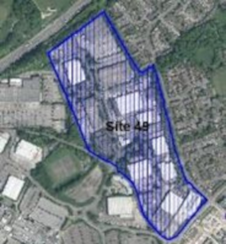
The following sites are safeguarded for employment uses in the current Local Plan (Core Strategy Policy CS12). It is proposed that they continue to be a safeguarded employment areas in the new Local Plan.
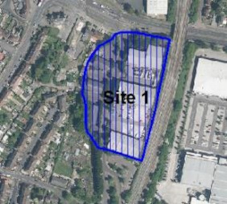
- Site 5: Employment Land at Filton Northfield (16.8ha)
- Site 48: Jupiter Road (7.8ha)
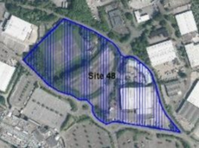
- Site 49: Patchway Industrial Estate (22.3ha)
.
Former Filton Airfield
View this Urban Lifestyle Area on our interactive map.
Summary of proposed planning approach
Core Strategy Policy CS26 (Cribbs / Patchway New Neighbourhood) allocated land on and around the former Filton Airfield for 5,700 homes as well as employment and supporting infrastructure. A Framework Agreement was signed in 2018 between the Council and developers and landowners to ensure that the required infrastructure for the whole site is delivered to support this level of development.
The current Council housing trajectory, however, plans for only 4,800 homes as one of the allocated Core Strategy sites in the wider area is no longer coming forward for housing development.
YTL who are the owners of a large area of the former Airfield have obtained planning permission for mixed use development including 2,675 homes (planning application number PT14/3867/O).
However, the recent planning permission for a new arena (within Bristol City Council area but directly adjacent to the site), a range of mixed-use leisure and commercial development and approval for a new train station to serve the Arena and wider area. In combination these recent developments are a key driving factor for how parts of the airfield site could be redeveloped.
It is understood that a large area of the existing airfield permission adjacent to the approved arena, train station and eastern section of the airfield, is being reconsidered for a new form of development by the site’s owners and developer YTL.
It has been indicated that they can deliver at least an additional 1,000 homes on this land over and above the existing planning permission and that this might come forward through a new planning application. This level of additional housing growth would be deliverable within the existing Framework Agreement. Any further uplift in housing numbers on this site would require a new approach to the provision of infrastructure.
The Arena development and delivery of and newly-planned transport improvements, such as the new rail station and metrobus route, offer significant potential for the remaining undeveloped land to be used for higher-density Urban Lifestyle approach. With a revised mixture of uses, new approaches to design and provision of homes, green spaces and employment opportunities. The Arena development also offers the opportunity to ensure significantly enhanced public bus and rail services and walking and cycling connectivity between communities in and around Cribbs Causeway, and the communities to the south and east.
Any new proposals or revised applications for development on this site will managed in accordance with the Urban Lifestyles policy to make the best use of land by optimising density.
It is likely that updated and new information on the intention for some sections of the airfield will come forward in early 2022. The development of our new Local Plan will consider future opportunities and aspirations for this site as they come forward.
Appropriate density range
The appropriate density for this area will be 105–160dph.
Future developments will be expected to fall in this density range, subject to meeting the requirements of the draft Urban Lifestyles and Density Policy. This sets out what would be required when developing a site in an Urban Lifestyles area to balance the investigation of higher densities with achieving high quality developments for people, places and the environment. (link to policy to be inserted in final public consultation, web version).
The location of a development site within an Urban Lifestyles area will be a key factor. As a starting point, subject to meeting the balancing requirements of the policy, sites which are very close to the centre of an area, near to shops, services and public transport options, would be expected to be developed around the upper level of the density range.
A site which is located further away from the shops and services would be expected to be developed at a density towards the lower end of the range. Sites which are beyond 800m from a town centre or transport hub will generally fall outside of the requirement to investigate meeting the density range.
Potential site allocations
No sites are proposed for allocation for new development, in this urban lifestyle area at this stage of the new Local Plan.
However, there are opportunities for parts of the approved scheme on the former Filton airfield to be re-submitted to maximise opportunities created by the new arena, train station and approach to optimising density set out in our new Local Plan.
Existing adopted Policy CS26 will be reviewed in line with our Urban Lifestyles approach and any future proposals that come forward during preparation of the new Local Plan. This may affect the current approach to safeguarded employment land as set out below. The North Fringe Masterplan will inform this approach and provide a new vision and ideas for change in this area.
Safeguarded employment areas
The following sites are safeguarded for employment uses in the current Local Plan (Core Strategy Policy CS12). It is proposed that they continue to be a safeguarded employment areas in the new Local Plan.
- Site 6d: Land East of A38, Filton/Patchway, Southern site – around NBC (16.1ha)
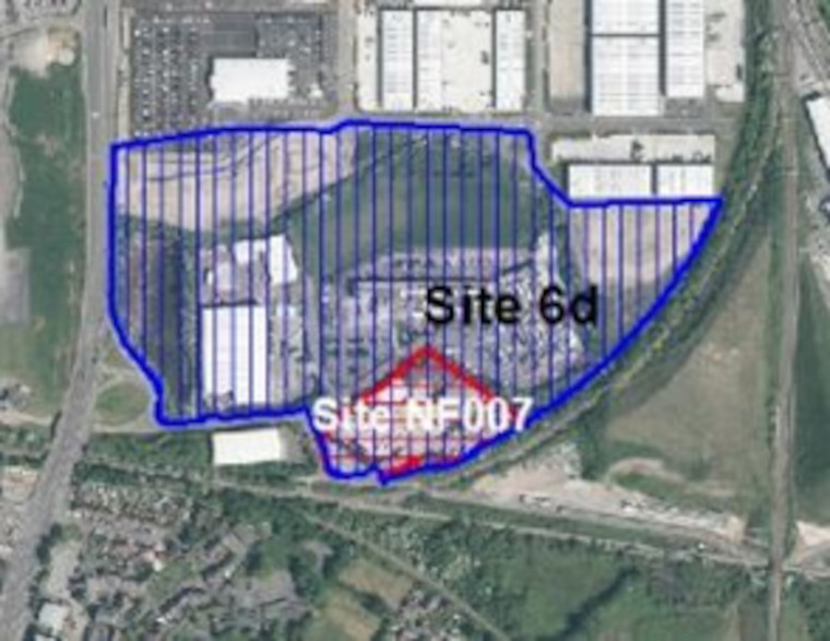
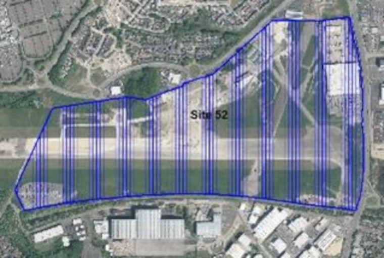
- Site 52: Land West of A38 (including runway and Royal Mail Depot) (up to 24ha)
The site is currently an interim safeguarded employment site in the adopted Core Strategy for up to 50ha of employment land. However, since adoption of the Core Strategy the approval of 2,675 homes (planning application number PT14/3867/O) has reduced the overall area remaining for safeguarded employment to 24ha.
The new Local Plan intends to redraw the extent of this safeguarded area to reflect the remaining 24ha of land, which it is intended to continue safeguarding for employment.
.
Patchway Town Centre
View this Urban Lifestyle Area on our interactive map.
Summary of proposed planning approach
Patchway town centre at Rodway Road is centred around a high street with local shops and community facilities, well connected to its adjoining residential areas. The wider area has a large number of key services and facilities including further shopping areas at Coniston Parade and along the A38. There are a range of bus connections.
Patchway rail station in Little Stoke is a key public transport link within 1,700 metres of the town centre but the A38 dual-carriageway is a significant linear barrier to access for the local community.
This area has potential as a focus for Urban Lifestyles around the town centre and rail station, with a role in creating a more coherent centre and sense of place.
Opportunities will be mainly focused on the redevelopment and regeneration of existing buildings and sites brought forward by landowners. There is also potential for higher density development around Patchway rail station but links will need to be improved across the A38 highway to allow better pedestrian movement through the area. In future new development will be managed in accordance with the Urban Lifestyles policy to make the best use of land by optimising density.
Developments at the higher end of the recommended density range for the area will be suitable for the centre of the Urban Lifestyle area with developments at the lower end of the density range being more appropriate further away from the centre.
Appropriate density range
The appropriate density for this area will be 80-120dph.
Future developments will be expected to fall in this density range, subject to meeting the requirements of the draft Urban Lifestyles and Density Policy. This sets out what would be required when developing a site in an Urban Lifestyles area to balance the investigation of higher densities with achieving high quality developments for people, places and the environment. (link to policy to be inserted in final public consultation, web version).
The location of a development site within an Urban Lifestyles area will be a key factor. As a starting point, subject to meeting the balancing requirements of the policy, sites which are very close to the centre of an area, near to shops, services and public transport options, would be expected to be developed around the upper level of the density range. A site which is located further away from the shops and services would be expected to be developed at a density towards the lower end of the range. Sites which are beyond 800m from a town centre or transport hub will generally fall outside of the requirement to investigate meeting the density range.
Potential site allocations
No sites are proposed for allocation for new development, in this urban lifestyle area at this stage of the new Local Plan.
Safeguarded employment areas
The following sites are safeguarded for employment uses in the current Local Plan (Core Strategy Policy CS12). It is proposed that they continue to be a safeguarded employment areas in the new Local Plan.
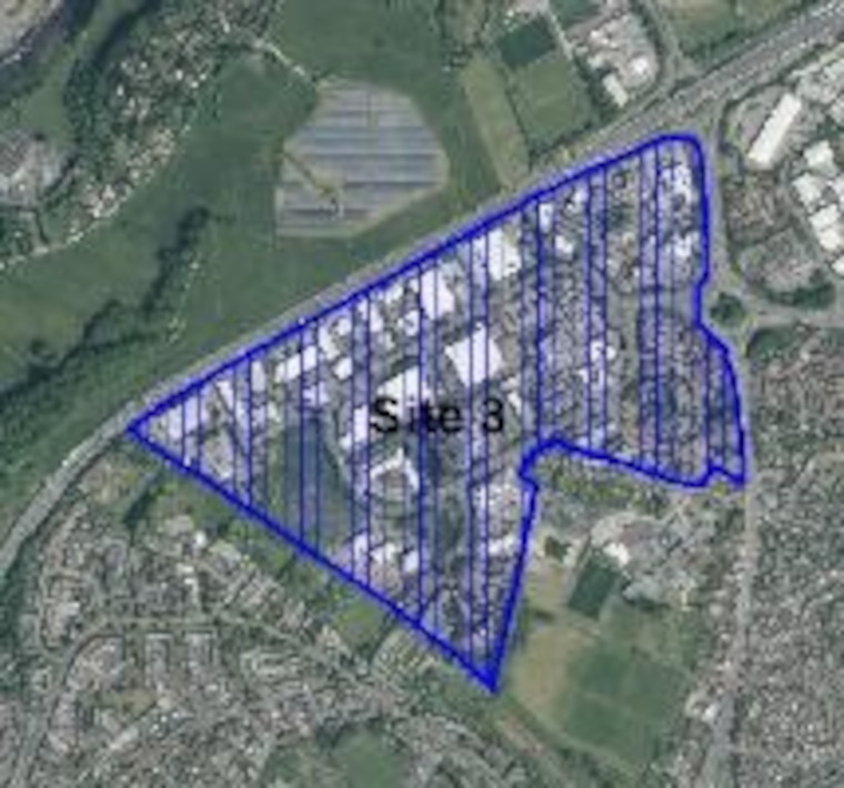
- Site 3: Aztec West (61.4ha)
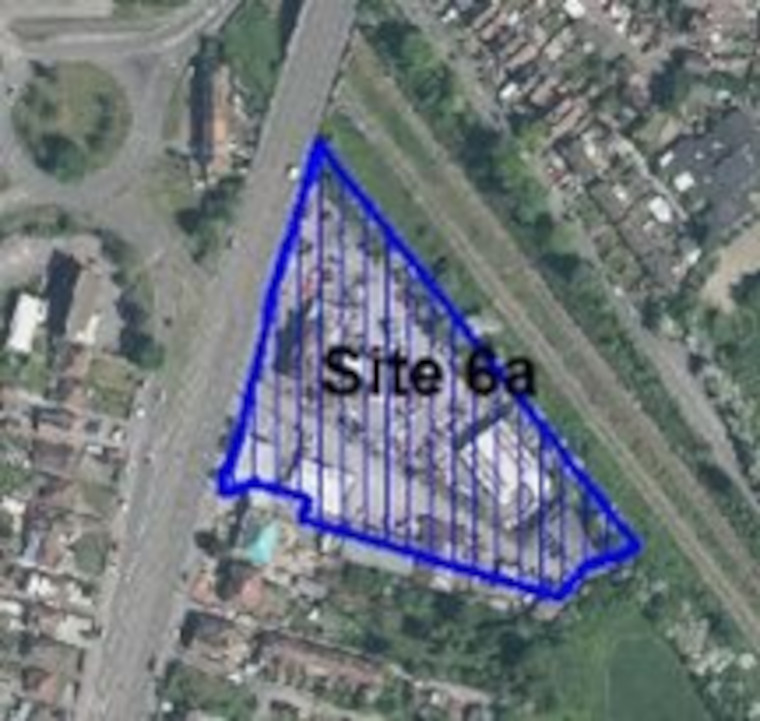
- Site 6a: Land East of A38, Filton/Patchway – north parcel (1.3ha)
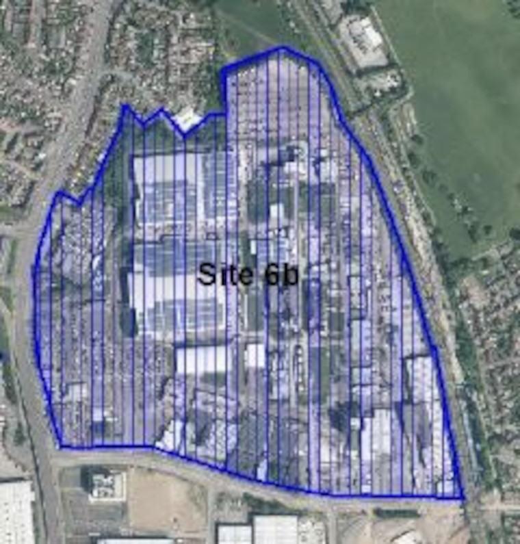
- Site 6b: Land East of A38, Filton/Patchway – Rolls Royce Main (35.2ha)
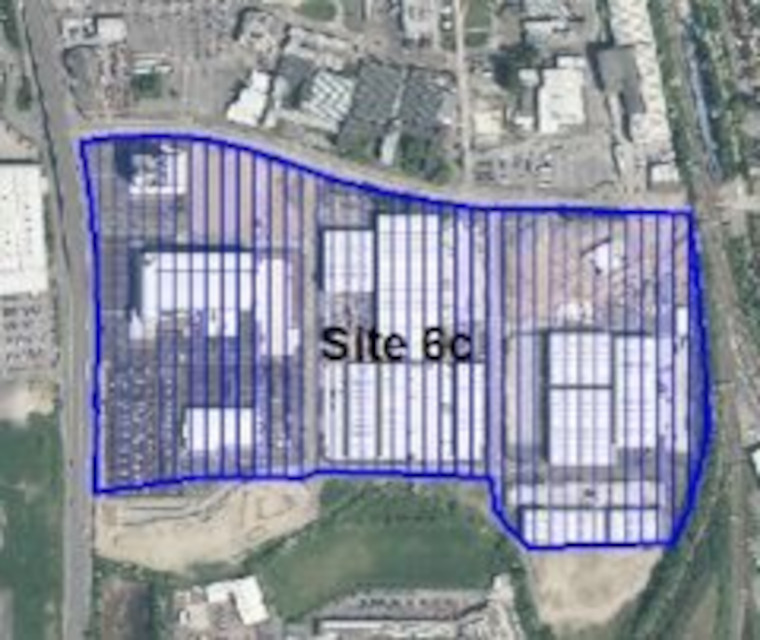
- Site 6c: Land East of A38, Filton/Patchway- South of B4057 (22.3ha)
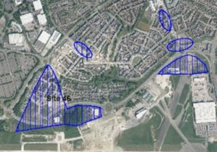
- Site 46: Employment Land at Filton Northfield (16.8ha)
.
Filton Town Centre
View this Urban Lifestyle Area on our interactive map.
Summary of proposed planning approach
Filton town centre is well situated to serve its community, and significant local employment centres. It contains a limited range of local shops as well as specialist retail outlets, a hotel and library. Filton Leisure Centre and Town Council offices are located nearby. However, there are issues with the quality of the public realm, pedestrian experience and walking connections around the town centre as well as to surrounding residential and employment areas due to severance by major roads.
Opportunities for further development are mainly focused on redevelopment and regeneration of existing buildings and sites brought forward by landowners. In future this type of new development will managed in accordance with the Urban Lifestyles policy to make the best use of land by optimising density. Developments at the higher end of the recommended density range for the area will be suitable for the centre of the Urban Lifestyle area with developments at the lower end of the density range being more appropriate further away from the centre.
New development should assist in attracting investment and footfall by:
- facilitating better links between different parts of the town centre
- improving the quality of the public realm and making the area attractive for investment in the retail and leisure sectors
- improving pedestrian access to the town centre from neighbouring residential and employment areas
- potentially introducing an element of higher-density housing, through mixed use developments
Appropriate density range
The appropriate density for this area will be 50-90dph.
Future developments will be expected to fall in this density range, subject to meeting the requirements of the draft Urban Lifestyles and Density Policy. This sets out what would be required when developing a site in an Urban Lifestyles area to balance the investigation of higher densities with achieving high quality developments for people, places and the environment.
The location of a development site within an Urban Lifestyles area will be a key factor. As a starting point, subject to meeting the balancing requirements of the policy, sites which are very close to the centre of an area, near to shops, services and public transport options, would be expected to be developed around the upper level of the density range. A site which is located further away from the shops and services would be expected to be developed at a density towards the lower end of the range. Sites which are beyond 800m from a town centre or transport hub will generally fall outside of the requirement to investigate meeting the density range.
Potential site allocations
Please note that this is the first stage of consultation on these potential site allocations. We are seeking your views at this stage and no final decisions have been made about changing the use of these sites.
Site name, address and area (ha):
Select the plus icon for more information on each site.
Land at Filton 20 Business Park, Golf Course Lane, Filton (12.4ha)
Site reference: NF004
Call for Sites reference: SG436
Site plan:
There are 2 potential options for allocation of this site – with fundamentally different land uses.
Option 1. Retain safeguarded employment land (CS12 designation) The SGC Employment Land Review recommends safeguarding of existing CS12 sites with investment to improve their long term employment viability.
Option 2. Proposed change of use to include residential uses on part of this site has been put forward by the landowner through the Call for Sites process.
Option 1. Continue to safeguard as employment area
Proposed use(s): employment
Capacity: employment TBC
Key site requirements:
- Employment development should make the most efficient use of land to optimise the potential of the site.
- Protect, enhance and provide Green Infrastructure and meet the requirements for Biodiversity Net Gain.
Option 2. Mixed use – employment with an element of residential
Proposed use(s): employment and residential
Capacity:
- employment – TBC
- residential – up to 350 homes
Key site requirements:
- Portion of the site to be retained for employment uses compatible with future mixed use role of the site.
- Residential element to be designed in accordance with SGC Urban Lifestyles areas and density policy (draft) and principles to optimise density on site.
- Employment development should make the most efficient use of land to optimise the potential of the site.
- New residential uses should be sited away from existing manufacturing and employment uses on neighbouring sites so as not to prejudice amenity of future residents or the operation of surrounding employment uses.
- Protect, enhance and provide Green Infrastructure and meet the requirements for Biodiversity Net Gain.
Viridor Waste Management, North Way, Filton (1.54ha)
Site reference: NF007
Call for Sites reference: SG735
Site plan:
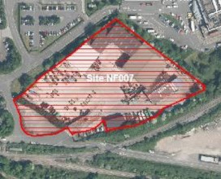
Proposed use(s): council waste management facility
Capacity: waste management facility
Key site requirements:
- Development should make the most efficient use of land to optimise the potential of the site.
- The Waste Management Team at South Gloucestershire has proposed for an expanded Waste Management Facility through a Call for Site submission.
- Proposal to remove the site from safeguarded employment and safeguard for Waste Management Facility.
- Protect, enhance and provide Green Infrastructure and meet the requirements for Biodiversity Net Gain.
Filton Clinic, Shields Avenue, Filton (0.15ha)
Site reference: NF009
Call for Sites reference: SG858
Site plan:
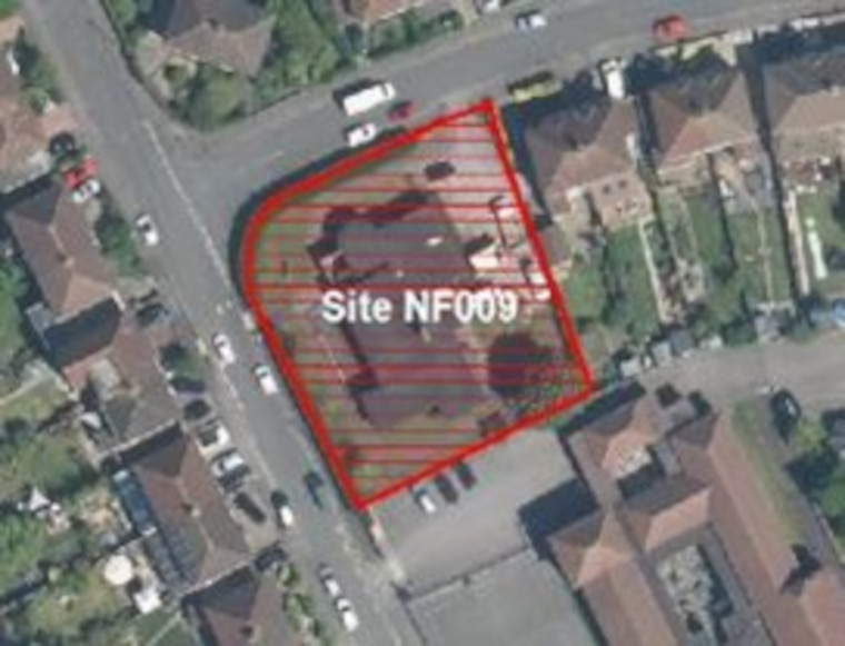
Proposed use(s): mixed use (retain health clinic and residential)
Capacity:
- retain health clinic: 300m2
- residential: up to 6 homes
Key site requirements:
- Retain and enhance health clinic on site in existing or redeveloped building
- Development should make the most efficient use of land to optimise the potential of this site
- Design in accordance with SGC Urban Lifestyles areas and density policy (Draft) and principles to optimise density on site
- Protect, enhance and provide Green Infrastructure and meet the requirements for Biodiversity Net Gain
The Plough and Horseshoe Inn, Gloucester Road, Filton (0.29ha)
Site reference: NF010
Call for sites reference: SG859
Site plan:
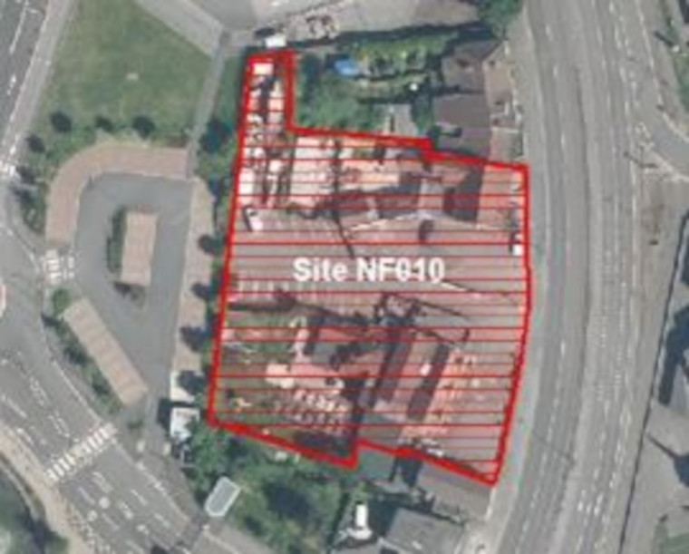
There are 2 potential options for allocation of this site – with fundamentally different land uses.
Option 1. Retain safeguarded employment land (CS12 designation) and public house use
The SGC Employment Land Review recommends safeguarding of existing CS12 sites with investment to improve their long-term employment viability
Option 2. Change of use to residential development has been proposed by the landowner through the Call for Sites process
Option 1. Public houses and continue to safeguard as employment area
Proposed use(s):
- public house
- employment
Capacity: employment – TBC
Key site requirements:
- Any future employment development proposals should make the most efficient use of land to optimise the potential of the site
- Protect, enhance and provide Green Infrastructure and meet the requirements for Biodiversity Net Gain.
Option 2. Allocate for residential development
Proposed use(s): residential
Capacity: up to 15 homes
Key site requirements:
- Design in accordance with SGC urban lifestyle areas and density policy (Draft) and principles to optimise density on site
- Would need to demonstrate that public house and employment (CS12) uses are no longer viable or required
- Demonstrate that residential users would not be affected by noise arising from adjacent employment uses and that residential uses would not prejudice the future operation of the employment areas
- Protect, enhance and provide Green Infrastructure and meet the requirements for Biodiversity Net Gain
Land at Filton Retail Park, Fox Den Road, Filton (0.51ha)
Site reference: NF011
Call for sites reference: SG869
Site plan:
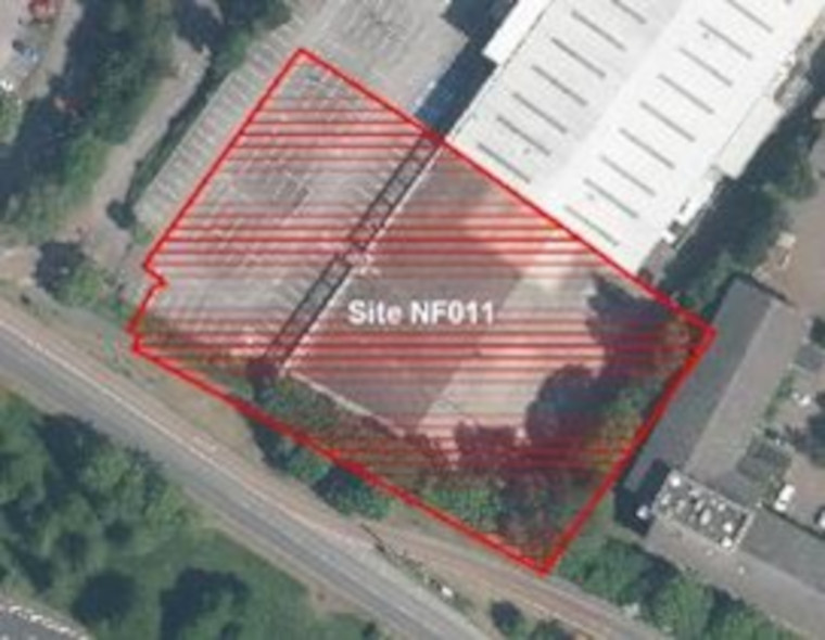
Proposed use(s): residential or student accommodation
Capacity: up to 40 homes
Key site requirements:
- Design in accordance with SGC urban lifestyle areas and density policy (Draft) and principles to optimise density on site
- Ensure safe, convenient and direct pedestrian access to UWE campus and from Filton Road through the site to the town centre and retail facilities.
- Protect, enhance and provide Green Infrastructure and meet the requirements for Biodiversity Net Gain.
.
Safeguarded Employment Areas
The following site in this area is safeguarded for employment uses in the current Local Plan (Core Strategy Policy CS12) but has received 2 Call for Site proposals for non-employment focused uses on parts of the existing employment area(s).
In this consultation we are therefore testing two options for each Call for Site, either retaining as an employment safeguarded area or allocating for a different mix of uses.
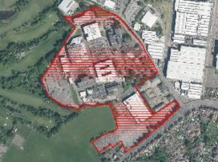
- Site 7: Land West of A38 and south of Hallen railway line – South (61.6ha)
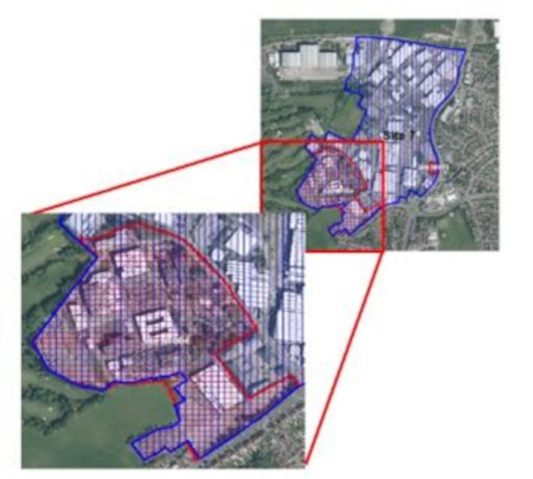
Potential Site Allocation note/Ref
Potential change to two parts of the site which includes 12.72ha highlighted in red on the map. The locations highlighted in red are Call for Site submissions. Please see potential site allocations NF004 and NF010 to understand more about the potential non-employment options. The remainder of the site in blue includes 48.88ha is proposed to continue to be safeguarded employment land.
.
Stoke Gifford District Centre, Parkway Station to Abbey Wood/UWE area
View this Urban Lifestyle Area on our interactive map.
Summary of proposed planning approach
This Urban Lifestyles area has one of the highest levels of access to public transport connections and facilities in the district including Bristol Parkway and Filton Abbey Wood stations and a metrobus route.
The wider area between Bristol Parkway rail station and the MOD/UWE to the south, includes all the elements needed to provide sustainable access to key services and facilities, as well as access to significant employment opportunities. This includes the Abbey Wood and Fox Den Road retail areas which provide access to a number of supermarkets and retail outlets for the surrounding communities. However, these are dispersed and separated by large-scale, campus-style developments, and the severance caused by road and rail infrastructure including the A4174 ring road. The University of West of England (UWE) campus contains a Metrobus and public transport hub but is difficult to access from surrounding communities because of poor walking and cycling legibility and route-quality.
At UWE, existing planning policy (CS12 and PSP47) safeguards a large area of land for employment uses. This land provides potential for a significant Urban Lifestyles’ development focusing on employment and education uses, with opportunities for enhanced connectivity between UWE and surrounding communities. Policies CS12, CS28 and PSP47 will need to be reviewed in respect of this area. Work is underway on a North Fringe Masterplan and a Parkway Station Masterplan which should start to address these issues. This area has potential for transformational change and would benefit from a long-term infrastructure investment plan and design guidance that sets out details of how the area might be regenerated to create a high-quality, more sensible, and better-functioning urban environment.
In future new development will be managed in accordance with the Urban Lifestyles policy. Developments at the higher end of the recommended density range for the area will be suitable for the centre of the Urban Lifestyle area with developments at the lower end of the density range being more appropriate further away from the centre.
New development should assist in moving to a more sustainable, compact and complete neighbourhood by:
- new and enhanced walking and cycling routes to connect major destinations, town centres, retail parks and employment opportunities, Bristol Parkway and other transport hubs and rail stations in the area.
- uplifting densities of new residential and employment development including making more efficient use of land by remodelling the extensive areas of car-parking in the area
- provision and enhancement of Green Infrastructure corridors and assets including street trees and on-site landscaping.
- providing access to a high-quality public realm and open space for residents and workers
- providing the services and facilities that future mixed use and residential communities may need
Appropriate density range
The appropriate density for this area will be 80-120 dph.
Future developments will be expected to fall in this density range, subject to meeting the requirements of the draft Urban Lifestyles and Density Policy. This sets out what would be required when developing a site in an Urban Lifestyles area to balance the investigation of higher densities with achieving high quality developments for people, places and the environment. (link to policy to be inserted in final public consultation, web version).
The location of a development site within an Urban Lifestyles area will be a key factor. As a starting point, subject to meeting the balancing requirements of the policy, sites which are very close to the centre of an area, near to shops, services and public transport options, would be expected to be developed around the upper level of the density range. A site which is located further away from the shops and services would be expected to be developed at a density towards the lower end of the range. Sites which are beyond 800m from a town centre or transport hub will generally fall outside of the requirement to investigate meeting the density range.
Potential site allocations
Please note that this is the first stage of consultation on these potential site allocations. We are seeking your views at this stage and no final decisions have been made about changing the use of these sites.
Site name, address and area (ha):
Select the plus icon for more information on each site.
Land between Brins Close, Field Farm Close and Hunts Ground Road, Stoke Gifford (0.97ha)
Site reference: NF001
Call for Sites reference: SG139
Site plan:
Proposed use(s):
- residential
- employment
- retail
Capacity:
- residential – up to 60 homes
- employment – TBC
- retail – TBC
Key site requirements:
- Site design should be led by principles of the Parkway Masterplan
- Employment development should make the most efficient use of land to optimise the potential of the site
- Residential element to be designed in accordance with SGC urban lifestyle areas and density policy (draft) and principles to optimise density on site
- Site design and layout should reflect key gateway location to Parkway Station
- Key pedestrian and cycle connections should be provided east west and north/south
- Provide for ecological connectivity to adjacent green spaces
- Protect, enhance and provide Green Infrastructure and meet the requirements for Biodiversity Net Gain
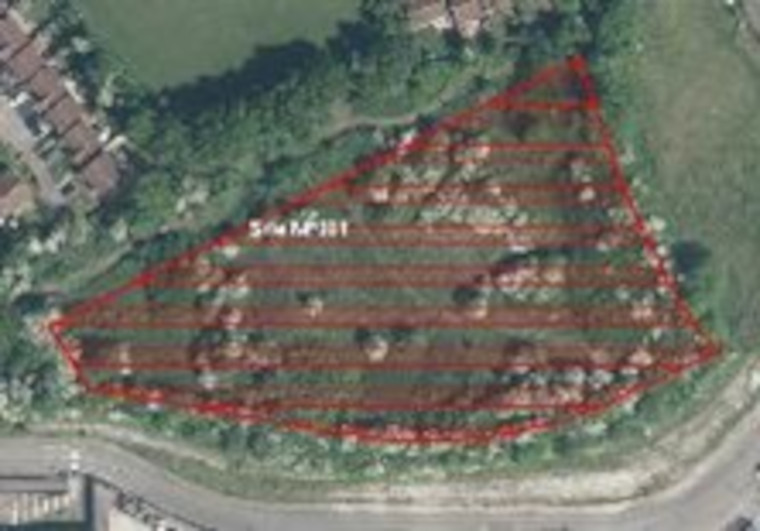
Oxbarton Mead Road (0.24ha)
Site reference: NF005
Call for Sites reference: SG498
Site plan:
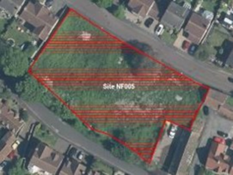
Proposed use(s): residential
Capacity: up to 7 homes
Key site requirements:
- Design in accordance with SGC urban lifestyle areas and density policy (draft) and principles to optimise density on site
- Protect, enhance and provide Green Infrastructure and meet the requirements for Biodiversity Net Gain
Land at the University of the West of England (9.12ha)
Site reference: NF008
Call for Sites reference: SG754
Site plan:
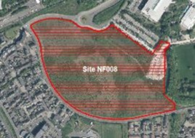
Proposed use(s):
- residential student accommodation
- education and employment
Capacity:
- residential student accommodation – up to 160 homes
- employment – 50,000m2 including education uses
Key site requirements:
- Design in accordance with SGC urban lifestyle areas and density policy and principles
(draft) to optimise density on site which is adjacent to the UWE transport hub - Employment or educational development should make the most efficient use of land to optimise the potential of the site
- Policy change required to Core Strategy and PSP plans to enable a mixed use scheme as the allocated use (Stadium) is no longer being progressed
- Development to include improving pedestrian and cycle links from and through the site to the transport hub and towards neighbouring residential areas, district centres and train stations
- Protect, enhance and provide Green Infrastructure and meet the requirements for Biodiversity Net Gain
.
Safeguarded employment areas
The following sites are safeguarded for employment uses in the current Local Plan (Core Strategy Policy CS12). It is proposed that they continue to be a safeguarded employment areas in the new Local Plan.
- Site 1: Abbey Wood Business Park – Emma Chris Way (1.7ha)
- Site 4: Bristol Business Park (14.6ha)
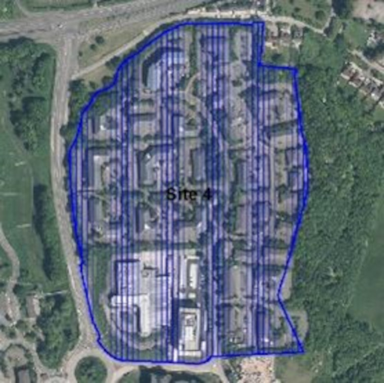
- Site 8: Ministry of Defence – Abbey Wood (36.4ha)
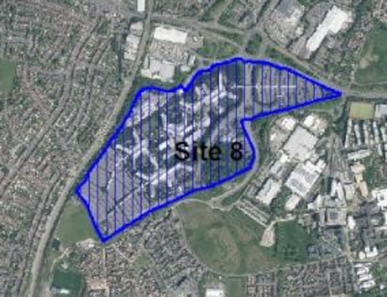
- Site 10: Parkway Business Park (29.6ha)
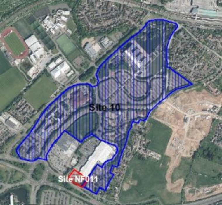
- Site 11: Parkway North Business Park (5.5ha)
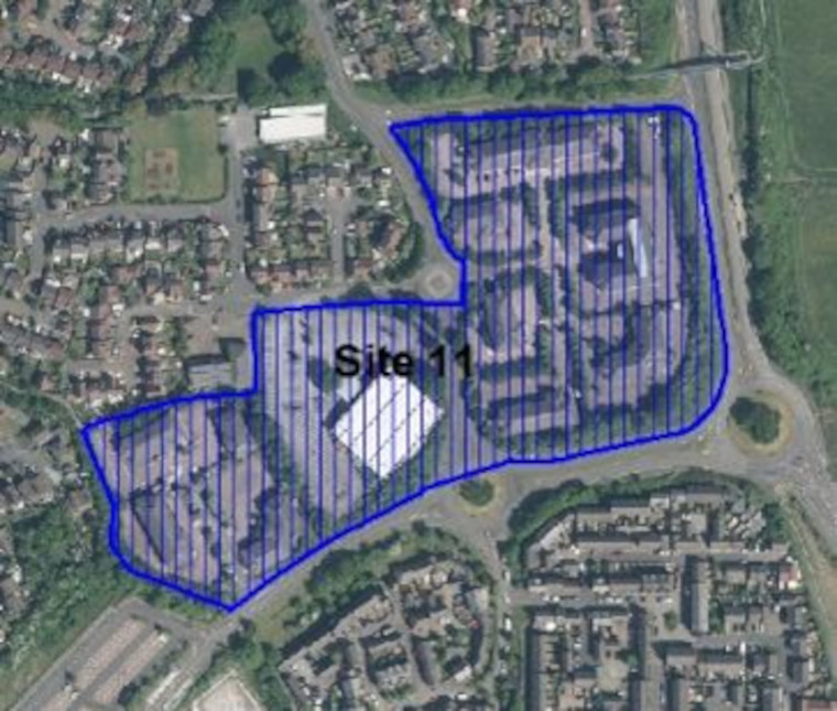
- Site 50: Pearce/Auto Techniques site (0.9ha)
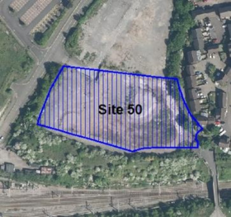
The following site in this area is also safeguarded for employment use in the current Local Plan (Core Strategy Policy CS12) and was allocated for use as a stadium. That proposal and scheme is no longer coming forward and there is a Call for Site proposal for non-employment focused uses on part or all the existing employment area(s).
- Site 51: University of the West of England (32.1ha)
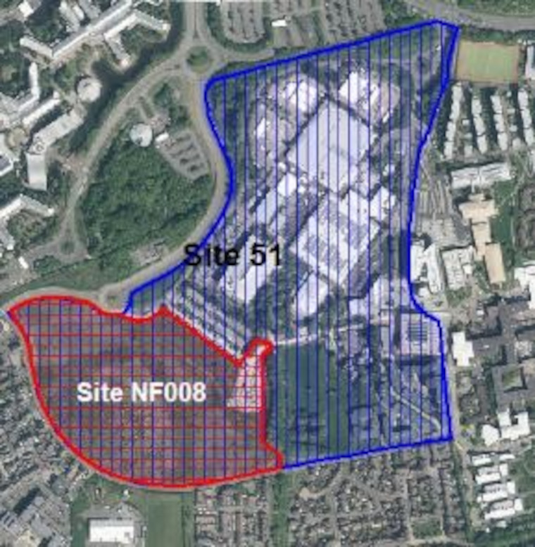
Potential Site Allocation note/Ref
Potential change to the current safeguarded employment site which includes 9.14ha highlighted in red on the map. The location highlighted in red is a Call for Site submission. Please see potential site allocation NF008 to understand more about the potential non-employment options. The remainder of the site in blue includes 22.96ha is proposed to continue to be safeguarded employment land.
.
Rest of the North Fringe urban area
Below we identify sites within the remainder of the North Fringe urban area which we propose to allocate as having potential for residential or mixed-use development, or to be safeguarded for employment uses. In these areas, which are less well connected to services and facilities, the general policies of the Local Plan will continue to apply rather than the draft Urban Lifestyles and Density Policy.
Potential site allocations: North Fringe – Winterbourne Ward
The sites below are located in the urban North Fringe in the Winterbourne ward area outside of the Urban Lifestyle Area of Stoke Gifford Town Centre and Parkway Station to Abbeywood/UWE. Please see the online interactive map for further context.
Please note that this is the first stage of consultation on these potential site allocations. We are seeking your views at this stage and no final decisions have been made about changing the use of these sites.
Site name, address and area (ha):
Select the plus icon for more information on each site.
Land on the North East side of Old Gloucester Road, Hambrook (2.58 ha)
Site reference: NF002
Call for Sites reference: SG414
Site plan:
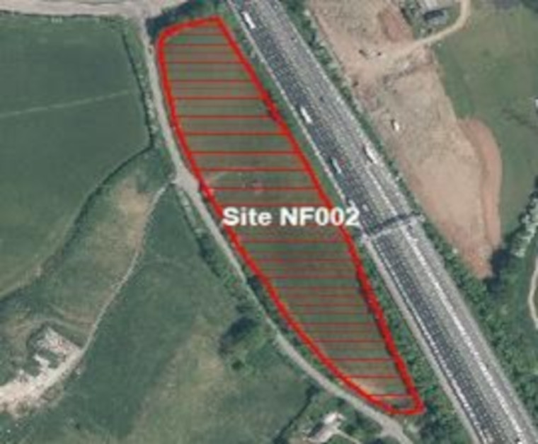
Proposed use(s): residential
Capacity: up to 75 homes
Key site requirements:
- Design in accordance with SGC urban lifestyle areas and density policy (draft) and principles to optimise density on site
- Design and layout should respond and link to the services and facilities at the East of Harry Stoke New Neighbourhood.
- Protect, enhance and provide Green Infrastructure and meet the requirements for Biodiversity Net Gain.
Land at Players Lane, Hambrook (1.75ha)
Site reference: NF003
Call for Sites reference: SG423
Site plan:
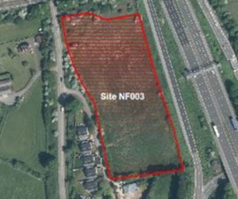
Proposed use(s): residential
Capacity: up to 60 homes
Key site requirements:
- Design in accordance with SGC urban lifestyle areas and density policy (draft) and principles to optimise density on site
- Design and layout should respond and link to the services and facilities at the East of Harry Stoke New Neighbourhood.
- Protect, enhance and provide Green Infrastructure and meet the requirements for Biodiversity Net Gain.
.
Safeguarded Employment Areas: North Fringe – Bradley Stoke North Ward
The following sites are safeguarded for employment uses in the current Local Plan (Core Strategy Policy CS12). It is proposed that they continue to be a safeguarded employment areas in the new Local Plan.
The sites below are within the North Fringe in the Bradley Stoke North ward area but sit outside any of the Urban Lifestyle Areas. The closest Urban Lifestyle Area is Bradley Stoke Town Centre. Please see the online interactive map for further context.
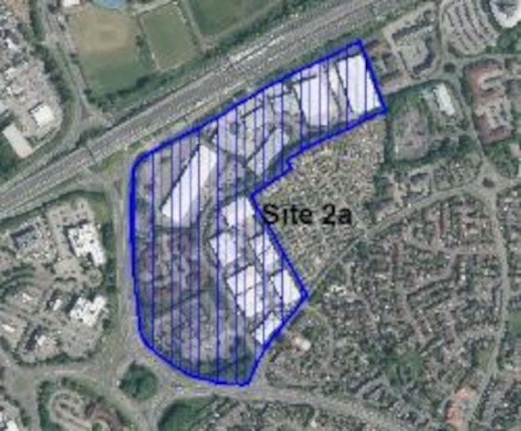
- Site 2a: Almondsbury Business Park – Western site (14.3ha)
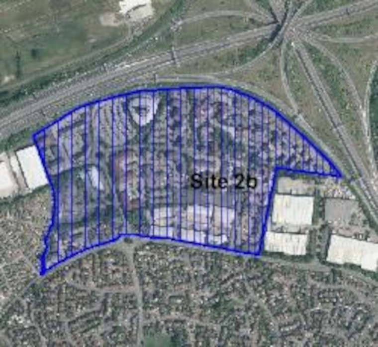
- Site 2b: Almondsbury Business Park- Central Site (21.7ha)
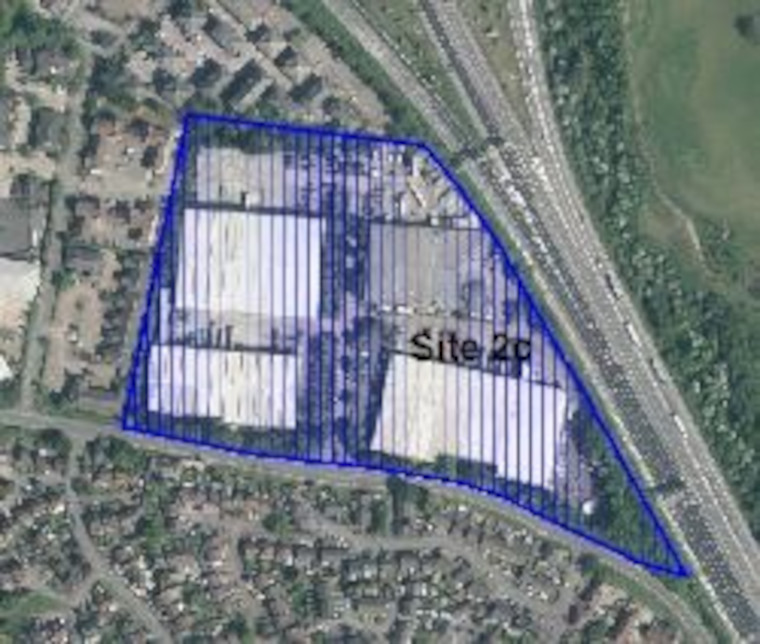
- Site 2c: Almondsbury Business Park- Eastern site (6.2ha)
Safeguarded Employment Areas: North Fringe – Bradley Stoke South Ward
The site below is within the North Fringe in the Bradley Stoke South ward area but sits outside any of the Urban Lifestyle Areas. The closest Urban Lifestyle Area is Bradley Stoke Town Centre. Please see the online interactive map for further context.
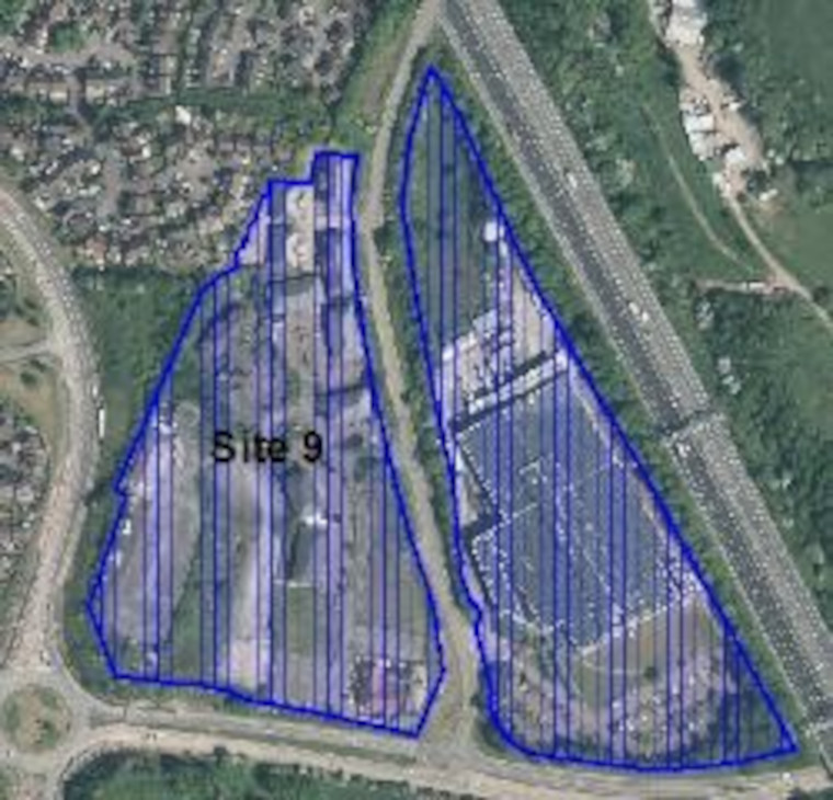
- Site 9: Old Gloucester Road, Hambrook (8.5ha)
Safeguarded Employment Areas: North Fringe – Charlton and Cribbs Ward
The sites below are within the North Fringe in the Charlton and Cribbs ward area but sit outside any of the Urban Lifestyle Areas. The closest Urban Lifestyle Area is Cribbs / The Mall. Please see the online interactive map for further context.
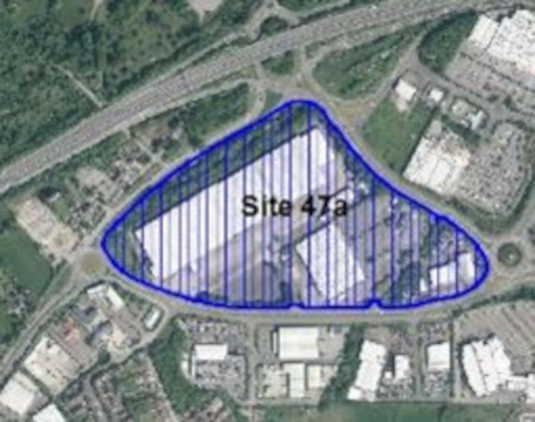
- Site 47a: Cribbs Causeway – North of Lysander Road (16.4ha)
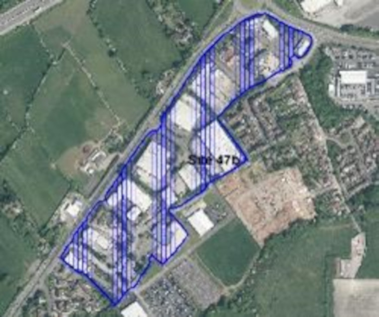
- Site 47b: Cribbs Causeway- The Laurels (10ha)
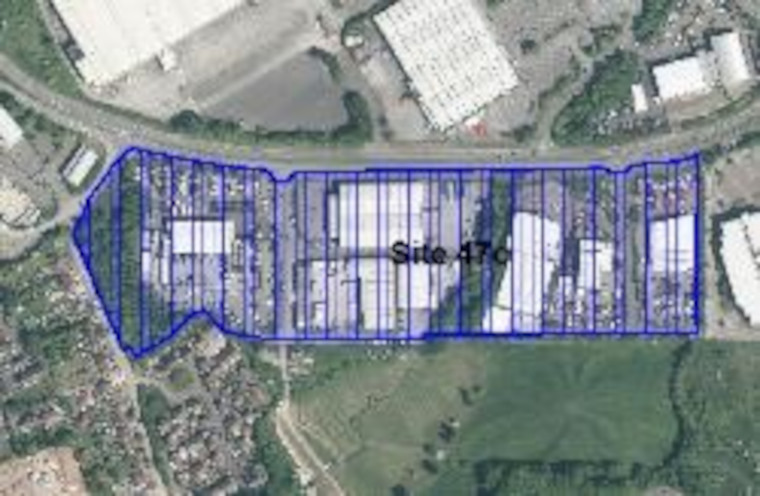
- Site 47c: Cribbs Causeway- South of Lysander Road (8ha)
East Fringe Urban Areas
The East Fringe urban area includes the communities of Downend, Emersons Green, Lyde Green, Staple Hill, Mangotsfield, Soundwell, Kingswood, Warmley, Cadbury Heath, Longwell Green and Hanham.
Below we have set out proposals for each of the places within these communities where the higher density urban lifestyles approach will be applied. At the end of the section we also identify sites within the remainder of the East Fringe urban area which we propose to allocate as redevelopment sites or continue to safeguard for employment. In these areas which are less well connected to services and facilities the general policies of the Local Plan will continue to apply.
In line with national policy, which requires us to look at previously used (brownfield) land first, we must consider options to redevelop sites within our urban areas to provide the new homes and other types of development that we need. The majority of sites we are consulting on now have been suggested by landowners and developers through the Call for Sites process. Some have been developed through detailed masterplanning where the council is co-ordinating the regeneration and transformation of high streets and key areas of focus. It is important to note that this is the first stage of consultation on the potential site allocations. We are seeking your views at this stage and no final decisions have been made about changing the use of these sites.
.
Emersons Green Town Centre
View this Urban Lifestyle Area on our interactive map.
Summary of proposed planning approach
Emersons Green Town Centre has a good range of supermarkets, retail stores and other services and community buildings. It was developed in the mid-1990s partly in an out-of-town retail park format, with large, single-storey unit stores on two sides of a very large, open, car park. This contrasts with the retail and community uses provided in Emersons Way, which have more in common with a traditional high street.
Public transport connections from Emersons Green Town Centre are reasonable, and the area has walking, cycling and public transport access to the enterprise zone at the Bristol & Bath Science Park as well as being well connected to residential communities to the south and west. The town centre also serves the newly developed community to the north across the ring road at Lyde Green.
Although this is a relatively newly-built town centre, opportunities may come through sites being brought forward by landowners for redevelopment to optimise densities and diversify uses. This could potentially include new homes and other uses to support local businesses and make more efficient use of the large areas of surface car parks whilst retaining the retail and community functions of the town centre. In future this type of new development will managed in accordance with the Urban Lifestyles policy to make the best use of land by optimising density whilst respecting local character and the amenity of existing residents. Development at the higher end of the recommended density range for the area will be suitable for the centre of the Urban Lifestyle area with developments at the lower end of the density range further away from the centre.
The large-scale residential development of Lyde Green, while offering community and education infrastructure, will offer limited opportunities for Urban Lifestyles sites as part of the new Local Plan, as it is newly developed.
The Bristol and Bath science park is some distance from Emersons Green Town Centre, and physically cut-off by the barrier of the A4174, although limited pedestrian connections do exist. This is an enterprise area with a number of significant employers. Although there is limited land available, any commercial, residential or mixed-use development sites that emerge will be expected to make efficient use of land, take advantage of the Metrobus connection, and make the best use of pedestrian and cycling links to Emersons Green Town Centre.
New developments should enhance the vitality of Emersons Green Town Centre by:
- enhancing walking and cycling routes and connections to nearby residential communities including Lyde Green, as well as the Science Park and other employment areas
- providing access to high-quality public realm and open space for residents and workers
- providing the services and facilities that future mixed-use and residential communities may need
Appropriate density range
The appropriate density for this area will be 45-70 dph.
Future developments will be expected to fall in this density range, subject to meeting the requirements of the draft Urban Lifestyles and Density Policy. This sets out what would be required when developing a site in an Urban Lifestyles area to balance the investigation of higher densities with achieving high quality developments for people, places, and the environment.
The location of a development site within an Urban Lifestyles area will be a key factor. As a starting point, subject to meeting the balancing requirements of the policy, sites which are very close to the centre of an area, near to shops, services and public transport options, would be expected to be developed around the upper level of the density range. A site which is located further away from the shops and services would be expected to be developed at a density towards the lower end of the range. Sites which are beyond 800m from a town centre or transport hub will generally fall outside of the requirement to investigate meeting the density range.
Potential site allocations
There are no proposed site allocations in this area.
Safeguarded Employment Areas
The following sites are safeguarded for employment uses in the current Local Plan (Core Strategy Policy CS12). It is proposed that they continue to be a safeguarded employment areas in the new Local Plan.
These existing safeguarded areas were set through the currently adopted Core Strategy based on a previous Masterplan for the Lyde Green development. However, we are aware that the development on the ground since that time may not entirely reflect the current boundary and uses for employment and where housing was built. Therefore the safeguarded boundaries may require redefining through this new Local Plan.
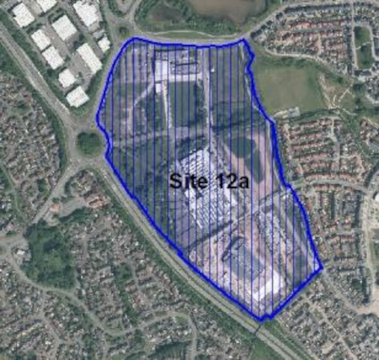
- Site 12a: Emersons Green- Science Park (22.2ha)
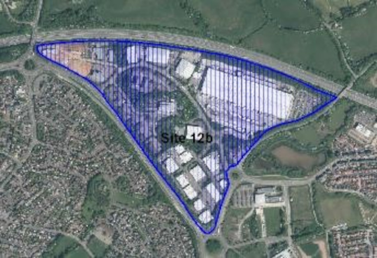
- Site 12b: Emersons Green- Emerald Park & Harlequin (34.3ha)
.
Downend Town Centre
View this Urban Lifestyle Area on our interactive map.
Summary of proposed planning approach
Downend is a compact town centre based around a small, relatively modern shopping centre and parades of local shops and other facilities along the A432. It offers a good level of services and facilities and a community centre within walking distance. Downend has bus connections to a range of locations, including Bristol City Centre and Yate. The centre and surrounding area, would be suitable for an Urban Lifestyles approach, if sites come forward for redevelopment by landowners. In future this type of new development will managed in accordance with the Urban Lifestyles policy. Developments at the higher end of the recommended density range for the area will be suitable for the centre of the Urban Lifestyle area with developments at the lower end of the density range being more appropriate further away from the centre.
New development and infrastructure investment should support the regeneration and vitality of the town centre by:
- responding to the existing character of the area including the adjoining residential areas and open spaces
- protecting the amenity of existing residents
Appropriate density range
The appropriate density for this area will be 40-115 dph.
Future developments will be expected to fall in this density range, subject to meeting the requirements of the draft Urban Lifestyles and Density Policy. This sets out what would be required when developing a site in an Urban Lifestyles area to balance the investigation of higher densities with achieving high quality developments for people, places and the environment.
The location of a development site within an Urban Lifestyles area will be a key factor. As a starting point, subject to meeting the balancing requirements of the policy, sites which are very close to the centre of an area, near to shops, services and public transport options, would be expected to be developed around the upper level of the density range. A site which is located further away from the shops and services would be expected to be developed at a density towards the lower end of the range. Sites which are beyond 800m from a town centre or transport hub will generally fall outside of the requirement to investigate meeting the density range.
Potential site allocations
Please note that this is the first stage of consultation on these potential site allocations. We are seeking your views at this stage and no final decisions have been made about changing the use of these sites.
Site name, address and area (ha):
Select the plus icon for more information on each site.
Rear of 32 Cleeve Hill (0.31ha)
Site reference: EF12
Call for Sites reference: SG879
Site plan:
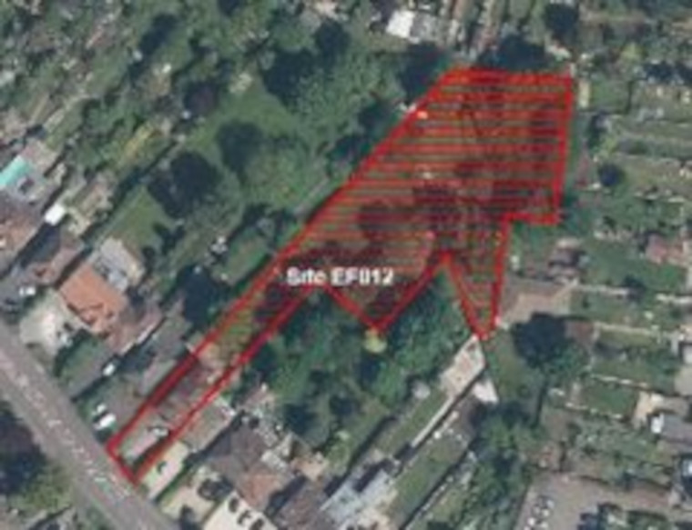
Proposed use(s): residential
Capacity: up to 10 homes
Key site requirements:
- Design in accordance with SGC urban lifestyle areas and density policy (draft) and principles to optimise density on site.
- Site design and layout should retain and respond to Tree Preservation Orders on site.
- Protect, enhance and provide Green Infrastructure and meet the requirements for Biodiversity Net Gain.
Downend Clinic, Buckingham Gardens (0.18 ha)
Site reference: EF010
Call for Sites reference: SG857
Site plan:
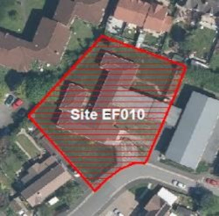
Proposed use(s):
- mixed use: retain health clinic
- residential
Capacity:
- health – 500m2
- residential – up to 10 homes
Key site requirements:
- Retain and enhance health clinic on site in existing or redeveloped building
- Residential uses to be designed in accordance with SGC urban lifestyle areas and density policy (draft) and principles to optimise density on site
- Protect, enhance and provide Green Infrastructure and meet the requirements for Biodiversity Net Gain.
.
Safeguarded employment areas
There are no sites currently safeguarded for employment uses in this location.
.
Staple Hill Town Centre
View this Urban Lifestyle Area on our interactive map.
Summary of proposed planning approach
Staple Hill Town Centre is based around a traditional high street. It has a mixture of independent shops and national food stores and a range of other key services and facilities. There are attractive historic buildings in the town centre, as well as some more recent buildings, some of which are of poor quality.
There are a number of bus links that connect the area to Bristol, Yate, Bath, Cribbs Causeway and Bristol Parkway station and it is close to the Bristol and Bath Railway Path. However, there are congestion issues on the High Street which cause significant issues with air quality.
The town centre could provide opportunities for Urban Lifestyles developments as buildings and sites are brought forward for redevelopment by landowners. There is potential to build above shops and optimise the densities of development on such sites made available on and around the High Street. There may also be opportunities to diversify the town centre through the redevelopment of under-used, commercial and employment sites to provide mixed-use development providing both homes and jobs and supporting local businesses.
In future this type of new development will managed in accordance with the Urban Lifestyles policy . Development at the higher end of the density range will be appropriate nearest the town centre and all new development should respect the character of the area and amenity of residents.
New development and infrastructure investment should support the regeneration and vitality of the town centre by:
- investing in the public realm, an increase in street trees, and the provision of improved, green-infrastructure connectivity to nearby parks and commons, and the open countryside
- taking account of, and protecting, views to green hillsides and key ridgelines that provide visual connectivity to open countryside east of the urban area
- improving walking and cycling links around the town centre and connections to the Bristol to Bath Railway path
Appropriate density range
The appropriate density for this area will be 65-120 dph.
Future developments will be expected to fall in this density range, subject to meeting the requirements of the draft Urban Lifestyles and Density Policy. This sets out what would be required when developing a site in an Urban Lifestyles area to balance the investigation of higher densities with achieving high quality developments for people, places and the environment.
The location of a development site within an Urban Lifestyles area will be a key factor. As a starting point, subject to meeting the balancing requirements of the policy, sites which are very close to the centre of an area, near to shops, services and public transport options, would be expected to be developed around the upper level of the density range. A site which is located further away from the shops and services would be expected to be developed at a density towards the lower end of the range. Sites which are beyond 800m from a town centre or transport hub will generally fall outside of the requirement to investigate meeting the density range.
Potential site allocations
Please note that this is the first stage of consultation on these potential site allocations. We are seeking your views at this stage and no final decisions have been made about changing the use of these sites.
Site name, address and area (ha):
Select the plus icon for more information on each site.
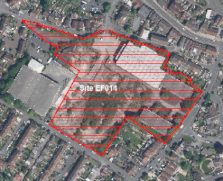
Exhibition House, North View, Staple Hill (0.47ha)
Site reference: EF011
Call for Sites Reference: SG877
Site plan:
There are 2 potential options for allocation of this site – with fundamentally different land uses.
Option 1. Retain safeguarded employment land (CS12 designation).
The SGC Employment Land Review recommends safeguarding of existing CS12 sites with investment to improve their long term employment viability.
Option 2. Change to residential uses on part of the employment site has been proposed by landowners through the Call for Sites process.
Option 1. Continue to safeguard as part of wider Employment Area
Proposed use(s): employment
Capacity: TBC
Key site requirements:
- Employment development should make the most efficient use of land to optimise the potential of the site
- Protect, enhance and provide Green Infrastructure and meet the requirements for Biodiversity Net Gain
Option 2. Residential
Propose use(s): residential
Capacity: up to 45
Key site requirements:
- Residential uses designed in accordance with SGC urban lifestyle areas and density policy and principles to optimise density on site.
- Not affect the viability of the remainder of the safeguarded employment area (adjacent site).
- Protect, enhance and provide Green Infrastructure and meet the requirements for Biodiversity Net Gain.
.
Safeguarded employment area
The following sites are currently safeguarded for employment uses in the Local Plan (Core Strategy Policy CS12). It is proposed that they continue to be safeguarded employment areas in the new Local Plan.
Please click on a site to view its location and extent on the consultation map.
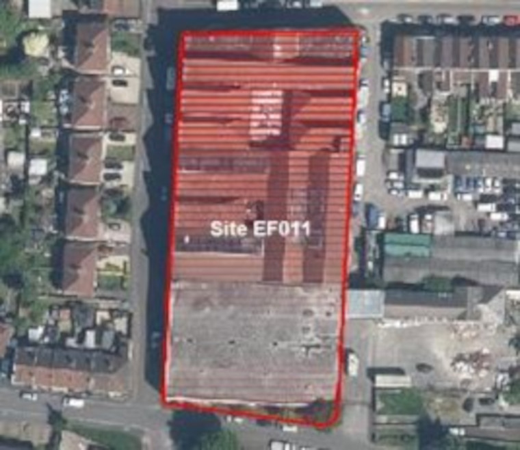
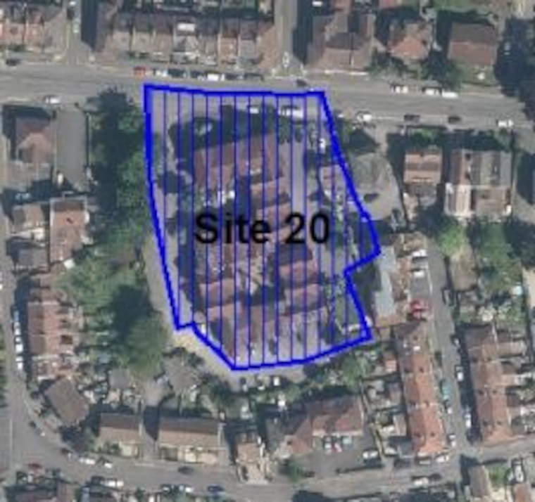
- Site 15: Bristol Uniforms Site (0.6ha)
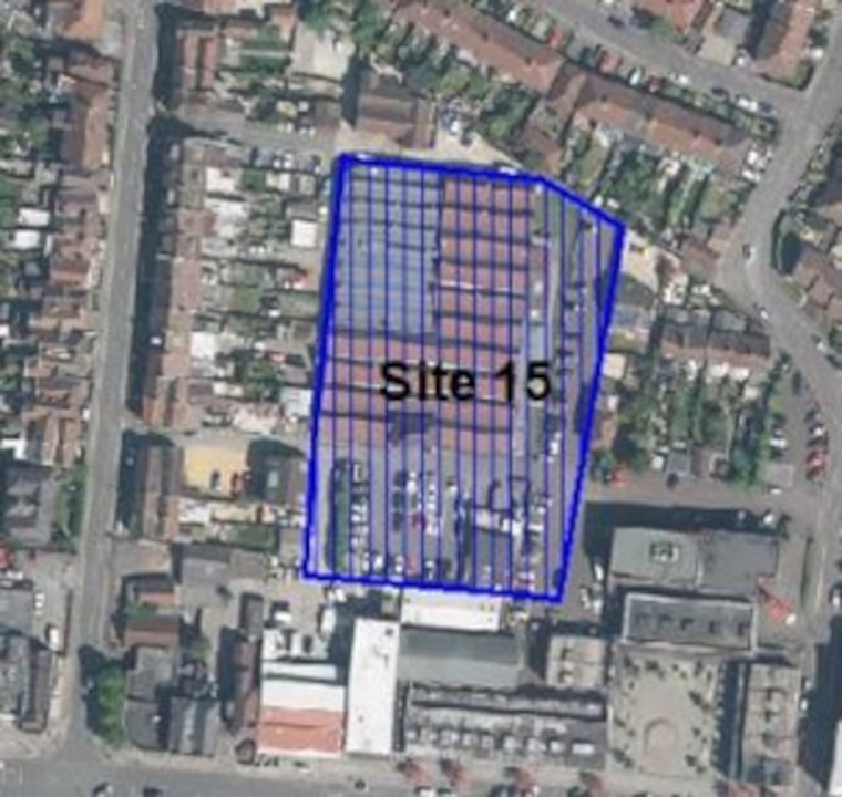
- Site 18: Station Road (10.1ha)
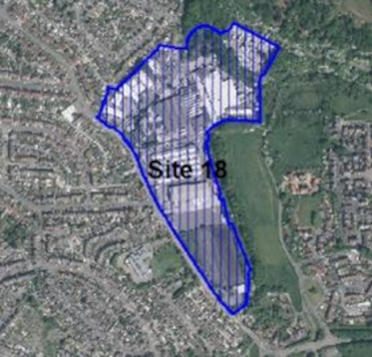
- Site 20: Eclipse Office Park (0.5ha)
The following site in Staple Hill is also currently protected for employment uses (Core Strategy CS12) but has received a Call for Site proposal for non-employment focused uses on part of the existing employment area.
In this consultation we are therefore testing two options, either retaining as an employment safeguarded area or allocating for a different mix of uses.
- Site 27: Hayward Industrial Estate (0.8ha)
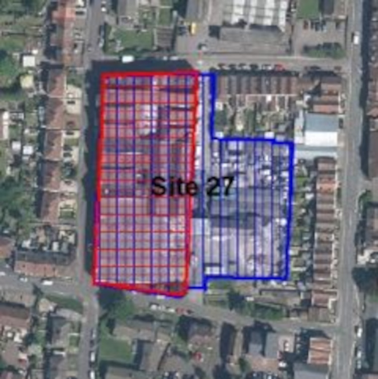
Potential Site Allocation note/Ref
Potential change to the existing safeguarded employment site which includes 0.47ha highlighted in red on the map. The location highlighted in red is a Call for Site submission. Please see potential site allocation EF011 to understand more about the potential non-employment options. The remainder of the site in blue includes 0.33ha is proposed to continue to be safeguarded employment land.
.
Kingswood Town Centre
Location
View this Urban Lifestyle Area on our interactive map.
Summary of proposed planning approach
The Kingswood Town Centre urban lifestyles area has been the subject of a detailed masterplanning exercise.
The masterplan responds to the decline in traditional retail and employment uses, and the need to maintain the town centre as a focus for the wider Kingswood community.
Whilst there remains a significant need for shops and services there is an opportunity to increase other sectors and land uses that will also benefit from being centrally located. The masterplan promotes a more diverse mix of uses including places to work, leisure and health facilities, and types of housing which are suited to the town centre. The plan identifies several underutilised sites where new development can take place and organises the town centre into 4 distinct sub-areas to guide the form and design of new buildings as well as protect existing features that contribute the identity of the area. Aligned with this it is recommended that the existing conservation area is extended to better protect the cluster of locally listed buildings within the historic core.
The masterplan aims to maintain the relevance and attractiveness of town centres for all visitors and residents, and further considers environmental factors such as reduced traffic congestion, better air quality, opportunities to enhance and connect green open spaces, improve the quality of streets, and promote the energy efficiency of new development.
The draft masterplan has been the subject of public consultation during 2021 and it is intended to develop the final masterplan by Spring 2022.
The principle ambition for each of the 4 distinct sub-areas aim to encourage a density of development to balance a greater mix of uses that will help to sustain the town centre as an active focus and destination for the wider community. The sub-areas identified are as follows:
- Mixed Commercial Quarter: There is a significant opportunity to invest in the Kings Chase Centre and other adjacent retail sites to increase the mix of uses, including additional retail, leisure and business space, whilst also exploring the potential for residential. There is scope at this central location to increase the scale of development to medium rise although overall building heights need to be tested to reduce any adverse impact on the neighbouring historic quarter.
- Historic and Cultural Heart: The approach here is to strengthen the historic identity by repairing and reusing many of the existing buildings. The ambition is to provide an evening destination around a pedestrianised section of Regent Street by increasing the number of food and drink uses as well as developing cultural destinations within underused buildings. There is limited scope for redevelopment although the block closest to Kings Chase does provide an opportunity to introduce new buildings that sit more comfortably alongside existing historic buildings and provide a better transition into the historic core.
- Civic Quarter: Development within the Civic Quarter will be aimed at restoring a small number of key vacant and underused sites in order to improve the approach into the town centre. Sites to the east of the area have been identified previously as longer term development potential, and provide an opportunity to establish a comprehensive mix of sustainable homes with easy access to community facilities, Kingswood Park and local schools.
- Live / work Urban Lifestyles: The area to the south of the retail core has been in transition, with sites protected for employment use developed for residential. There is an opportunity to promote a refined model of development which retains spaces for business and develops a more urban and integrated design approach to delivering homes. There will be a greater emphasis on mixed use, communal amenity space and usable public spaces. The existing scale of buildings such as the former Lucas factory, illustrate the potential for exploring medium rise development rising to five or six storeys, in order to create a vibrant mixed use focus for the live/work neighbourhood.
Appropriate density range
The residential density figures generated within the Kingswood Masterplan aim to provide an efficient use of land whilst maintain a scale of development appropriate to Kingswood town centre being of a low to medium rise. As such an appropriate new residential development should be within a density range of up to 60-120dph.
Higher densities will be more appropriate in and around the high street and main public transport locations. Optimising densities within this range in Kingswood Urban Lifestyles area, will be dependent on meeting other requirements of the emerging Urban Lifestyle policy and policies in our local plan, to avoid harm on local communities, the character and assets of the area.
Potential Site allocations
Please note that this is the first stage of consultation on these potential site allocations. We are seeking your views at this stage and no final decisions have been made about changing the use of these sites.
Site name, address and area (ha):
Select the plus icon for more information on each site.
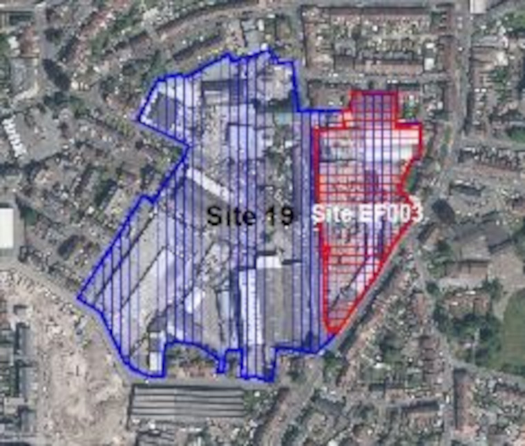
Lucas Works, Kingswood (1.8ha)
Site reference: EF003
Call for Sites reference: SG077
Site plan:
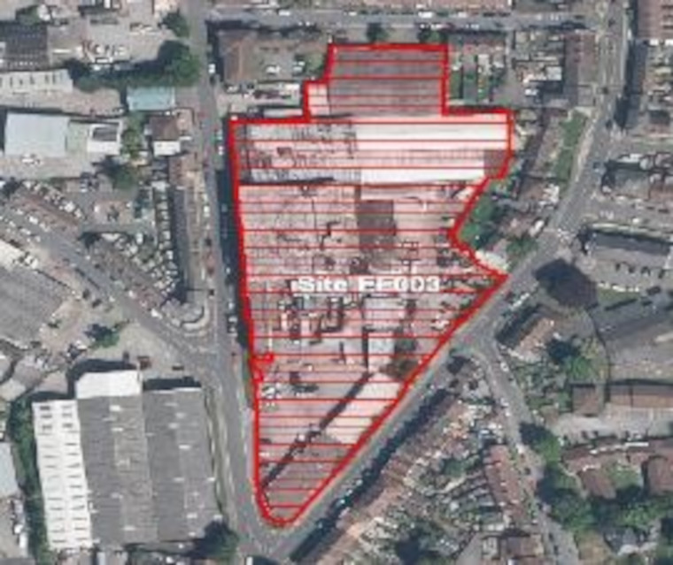
There are 2 potential options for allocation of this site – with fundamentally different land uses.
Option 1. Retain safeguarded employment land (CS12 designation).
The SGC Employment Land Review recommends safeguarding of existing CS12 sites with investment to improve their long term employment viability.
Option 1. Allocate for a mix of employment and residential uses.
There is extensive masterplan work ongoing in the area which includes proposals to bring forward certain sites opportunities as part of an overall regeneration programme
Option 1. Continue to safeguard as employment area
Proposed use(s): employment
Capacity: TBC
Key site requirements:
- Employment development should make the most efficient use of land to optimise the potential of the site and having regard to parameters for character and massing in accordance with the Kingswood Masterplan.
- Protect, enhance and provide Green Infrastructure and meet the requirements for Biodiversity Net Gain.
Option 2. Mixed use
Proposed use(s):
- employment
- residential – mix of houses and apartments
Capacity:
- employment – 3000m2
- residential – up to 140 homes
Key site requirements:
- Employment led mixed use proposal on site.
- Residential uses to be designed in accordance with SGC urban lifestyles areas and density policy (draft) and principles to optimise density on site and having regard to parameters for character and massing in accordance with the Kingswood Masterplan.
- Employment development should make the most efficient use of land to optimise the potential of the site and having regard to parameters for character and massing in accordance with the Kingswood Masterplan.
- Provide an element of modern employment/commercial uses compatible with new homes.
- New areas of high-quality public realm and landscaping including improvements to Moravian Road and the inclusion of a focal public space.
- Protect, enhance and provide Green Infrastructure and meet the requirements for Biodiversity Net Gain.
Kings Chase Shopping Centre, Kingswood (1.8 ha)
Site reference: EF015
Call for Sites reference: SG899
Site plan:
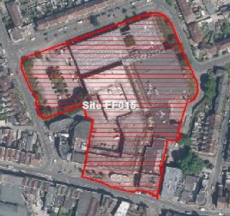
Proposed use(s):
- retail
- leisure centre – Including swimming pool with reorganised on-site parking
- cinema and/or commercial leisure
- housing – apartments above ground floor uses
- employment space – flexible office hub
Capacity:
- retail – TBC
- leisure centre – 3,500m2
- cinema and/or commercial leisure – 1000m2
- housing – up to 100 homes
- employment – 700m2
Key site requirements:
- Improved retail environment to include investment in public realm, public toilets, centre management suite, lighting and signage.
- Enhanced links to improved Regent Street public transport hub.
- Residential uses to be designed in accordance with SGC urban lifestyles areas and density policy (draft) and principles to optimise density on site and having regard to parameters for character and massing in accordance with the Kingswood Masterplan.
- Employment development should make the most efficient use of land to optimise the potential of the site and having regard to parameters for character and massing in accordance with the Kingswood Masterplan.
- Leisure Centre to provide new facilities comparable with existing provision at Soundwell.
Housing and Employment space to be independently accessible. - Protect, enhance and provide Green Infrastructure and meet the requirements for Biodiversity Net Gain.
.
Safeguarded employment areas
The following sites are safeguarded for employment uses in the current Local Plan (Core Strategy Policy CS12). It is proposed that they continue to be safeguarded employment areas in the new Local Plan.
- Site 16: Oatley Trading Estate (0.3ha)
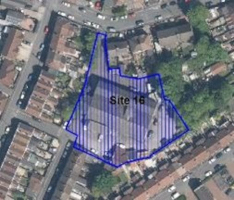
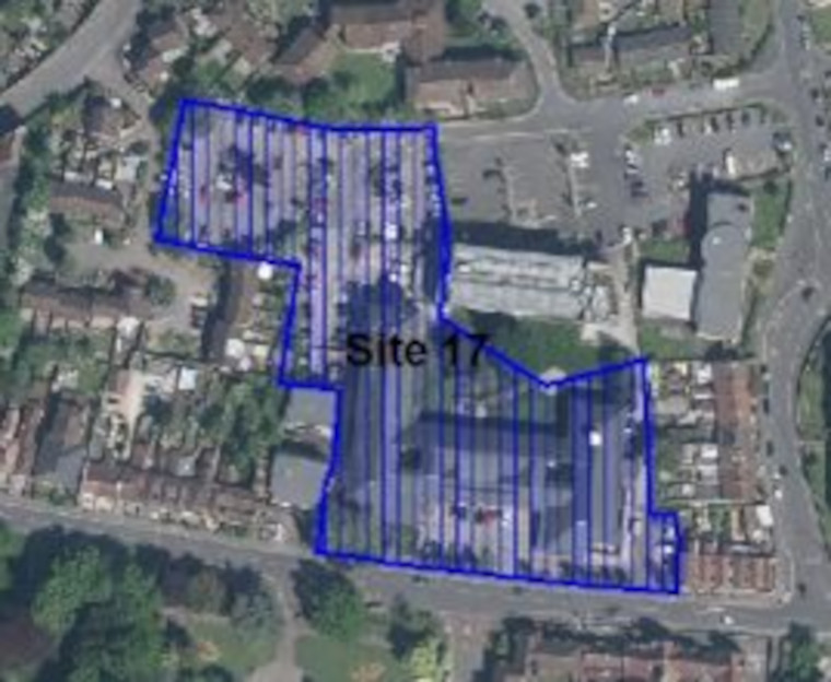
- Site 17: The Civic Centre Kingswood (1ha)
The following existing safeguarded employment area in Kingswood has received a Call for Site proposal for change of use and is also a focus of masterplan proposals for non-employment focused uses on part or all the existing employment area.
In this consultation we are therefore testing two options, either retaining as an employment safeguarded area or allocating for a different mix of uses.
- Site 19: North of Douglas Road (6.2ha)
Potential Site Allocation note/Ref
Potential change to approximately 4.8ha of the safeguarded employment area, to mixed use residential. Please see proposed site allocation EF003 ‘Lucas Works’ above to understand more about the non- employment options suggested.
.
Hanham Town Centre
View this Urban Lifestyle Area on our interactive map.
Summary of proposed planning approach
The Hanham Town Centre urban lifestyles area is based around the High Street and surrounding area. The High Street is a traditional shopping street with a range of mainly independent shops as well as services and community buildings. It is largely Victorian in character.
Opportunities for further development are mainly focused on redevelopment and regeneration of existing buildings and sites brought forward by landowners. In future this type of new development will managed in accordance with the Urban Lifestyles policy. This policy will ensure that development makes the best use of land by optimising density whilst respecting the existing amenity and historic character of the High Street and surrounding areas. Developments at the higher end of the recommended density range for the area will be suitable for the centre of the Urban Lifestyle area with developments at the lower end of the density range further away from the centre.
Appropriate density range
The appropriate density for this area will be 50-90 dph.
Future developments will be expected to fall in this density range, subject to meeting the requirements of the draft Urban Lifestyles and Density Policy. This sets out what would be required when developing a site in an Urban Lifestyles area to balance the investigation of higher densities with achieving high quality developments for people, places and the environment.
The location of a development site within an Urban Lifestyles area will be a key factor. As a starting point, subject to meeting the balancing requirements of the policy, sites which are very close to the centre of an area, near to shops, services and public transport options, would be expected to be developed around the upper level of the density range. A site which is located further away from the shops and services would be expected to be developed at a density towards the lower end of the range. Sites which are beyond 800m from a town centre or transport hub will generally fall outside of the requirement to investigate meeting the density range.
Potential Site allocations
Please note that this is the first stage of consultation on this potential site allocations. We are seeking your views at this stage and no final decisions have been made about changing the use of these sites.
Site name, address and area (ha):
Select the plus icon for more information on each site.
Land at former Kleeneze, Anstey’s Road, Hanham (3.16)
Site reference: EF014
Call for Sites reference: SG428
Site plan:
Proposed use(s):
- housing – including potential Extra-Care housing
- employment space
Capacity:
- housing – up to 200 homes
- employment – TBC
Key site requirements:
- Design in accordance with SGC urban lifestyle areas and density policy (draft) and principles to optimise density on site
- Provide an element of modern employment/commercial uses compatible with new homes
- Employment development should make the most efficient use of land to optimise the potential of the site
- New areas of high-quality public realm and landscaping including public square to north of site
- Provide enhanced pedestrian links to the High Street
- Protect, enhance and provide Green Infrastructure and meet the requirements for Biodiversity Net Gain.
.
Safeguarded Employment Areas
The following site is safeguarded for employment uses in the current Local Plan (Core Strategy Policy CS12). It is proposed that it continues to be a safeguarded employment area in the new Local Plan.
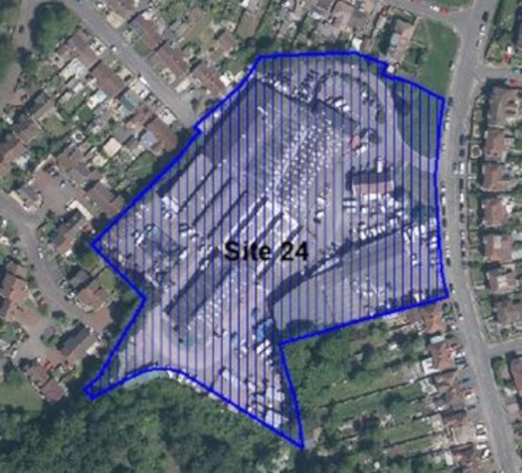
- Site 24: Hanham Business Park (2ha)
The following site in Hanham is also currently protected for employment uses (Core Strategy CS12) but has received a Call for Site proposal for non-employment focused uses on part of the existing employment area.
In this consultation we are therefore testing two options, either retaining as an employment safeguarded area or allocating for a different mix of uses.
- Site 25: Former Kleeneze Site (3.1ha)
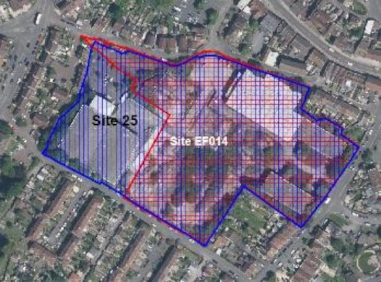
Potential Site Allocation note/Ref
Potential change to approximately 2.74ha of the safeguarded employment area to mixed use residential development. Please see proposed site allocation EF014 ‘Kleeneze’ above to understand more about the non-employment options suggested.
.
Longwell Green Retail Area
View this Urban Lifestyle Area on our interactive map.
Summary of proposed planning approach
Longwell Green Retail Park, on the south-eastern edge of the urban area, was planned in the 1980s and includes large-format stores that sell DIY and household goods. There are also a number of smaller, mainly clothing, stores. The area has public transport links to Bristol, Bath and Keynsham, however, links to the rest of the district are poor. Longwell Green retail park also benefits from walking and cycling access to a community centre, a wide range of supermarkets, and other services and facilities and is near a cinema and leisure centre.
The area is functional in character and dominated by large-format stores and surface car-parking. Opportunities may come through sites being brought forward by landowners for more efficient uses of land, that introduce a greater range of uses at a density appropriate to the location. This could potentially include different business uses as well as new homes which support local businesses and make more efficient use of the large areas of surface car parks. In future this type of new development will managed in accordance with the Urban Lifestyles policy to make the best use of land by optimising density whilst respecting local character and the amenity of existing residents. Development at the higher end of the recommended density range for the area will be suitable for the centre of the Urban Lifestyle area with developments at the lower end of the density range further away from the centre.
New development should assist in moving to a more sustainable, compact and complete neighbourhood by:
- providing access to a high-quality public realm and open space for residents and workers
- providing the services and facilities that future mixed use and residential communities may need
- improving public transport, walking and cycling connections within the area as well as other key destinations
Appropriate density range
The appropriate density for this area will be 100-130 dph.
Future developments will be expected to fall in this density range, subject to meeting the requirements of the draft Urban Lifestyles and Density Policy. This sets out what would be required when developing a site in an Urban Lifestyles area to balance the investigation of higher densities with achieving high quality developments for people, places and the environment.
The location of a development site within an Urban Lifestyles area will be a key factor. As a starting point, subject to meeting the balancing requirements of the policy, sites which are very close to the centre of an area, near to shops, services and public transport options, would be expected to be developed around the upper level of the density range. A site which is located further away from the shops and services would be expected to be developed at a density towards the lower end of the range. Sites which are beyond 800m from a town centre or transport hub will generally fall outside of the requirement to investigate meeting the density range.
Potential site allocations
No sites are proposed for allocation for new development in this urban lifestyle area at this stage of the new Local Plan.
Safeguarded employment areas
The following site is safeguarded for employment uses in the current Local Plan (Core Strategy Policy CS12). It is proposed that it continues to be a safeguarded employment area in the new Local Plan.
- Site 22: Longwell Green Industrial Estate (9.8ha)
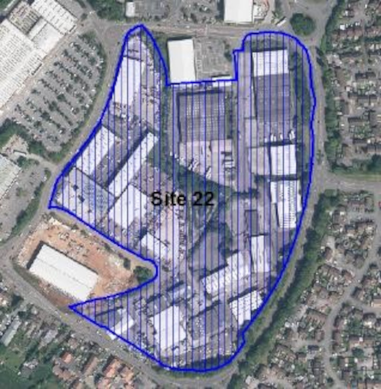
.
Rest of East Fringe Urban Area
Below we identify sites within the remainder of the East Fringe urban area which we propose to allocate as having potential for residential or mixed use development or to be safeguarded for employment uses. In these areas which are less well connected to services and facilities the general policies of the Local Plan will continue to apply rather than the draft Urban Lifestyles and Density Policy.
Potential Site allocations: East Fringe in the Boyd Valley Ward
The two sites below are located in the East Fringe in the Boyd Valley Ward but are outside of the Emersons Green Town Centre Urban Lifestyle Area. Please see the online interactive map for further context.
Please note that this is the first stage of consultation on these potential site allocations. We are seeking your views at this stage and no final decisions have been made about changing the use of these sites.
Site name, address and area (ha):
Select the plus icon for more information on each site.
Land north and east of Lyde Green Road, Emersons Green (1.36ha)
Site reference: EF001
Call for Sites reference: SG053
Site plan:
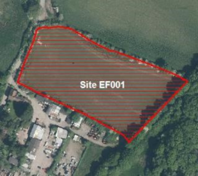
Proposed use(s): residential
Capacity: up to 30 homes
Key site requirements:
- Development should make the most efficient use of land to optimise the potential of this site
- Protect, enhance and provide Green Infrastructure and meet the requirements for Biodiversity Net Gain.
Land adjacent to Lyde Green Farm, Emersons Green (Land ….
Site reference: EF006
Call for Sites reference: SG347
Site plan:
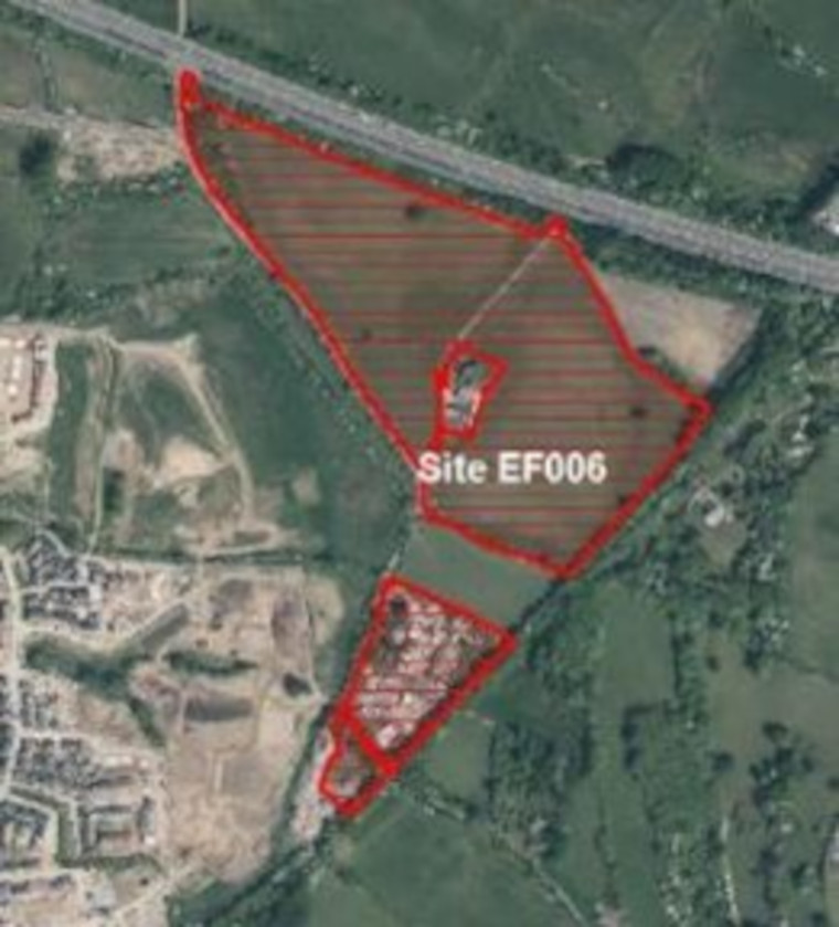
There are 2 potential options for allocation of this site – with fundamentally different land uses.
Option 1. Retain the safeguarded employment land element of this Call for Site with residential on the remainder of the site(CS12 designation) with enhanced site criteria
The SGC Employment Land Review recommends safeguarding of existing CS12 sites with investment to improve their long-term employment viability
Option 2. Residential use on the whole site has been proposed by the through the Call for Sites process
Option 1. Continue to safeguard existing Employment Area on site and new residential on remaining part of site
Proposed use(s):
- employment
- residential
Capacity:
- employment – TBC
- residential – up to 120 homes
Key site requirements:
- Development should make the most efficient use of land to optimise the potential of this site
- Retain existing safeguarded employment area (approx. 4.8ha site 12c. See employment safeguarding section).
- A suitable buffer should be applied between safeguarded employment area and remaining site for residential.
- A suitable buffer should be applied to reduce impact on adjacent Lyde Green Farm SNCI
- Design layout and massing of the development should respect the setting of grade II and grade II* heritage assets at Lyde Green farm
- Protect, enhance and provide Green Infrastructure and meet the requirements for Biodiversity Net Gain.
Option 2. Residential
Proposed use(s): residential
Capacity: up to 180 homes
Key site requirements:
- Development should make the most efficient use of land to optimise the potential of this site
- The site had an application (P19/1275/F) previously approved which accepted the principle of residential on site.
- A suitable buffer should be applied to reduce impact on adjacent Lyde Green Farm SNCI
- Design layout and massing of the development should respect the setting of grade II and grade II* heritage assets at Lyde Green farm.
- Protect, enhance and provide Green Infrastructure and meet the requirements for Biodiversity Net Gain.
.
The following area in the East Fringe Boyed Valley Ward is also currently safeguarded for employment use in the Local Plan (Policy CS12) but have received Call for Site proposal for non-employment focused uses on part or all the existing employment area.
In this consultation we are therefore testing two options, either retaining as an employment safeguarded area or allocating for a different mix of uses.
- Site 12c: Emersons Green Vertex Park & Residual (21.5ha)
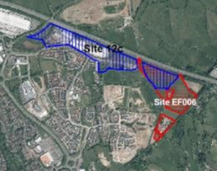
Potential Site Allocation Reference
Potential change to 4.8ha of the safeguarded employment area, at eastern extent. Please see proposed site allocation EF006 to understand more about the non-employment options suggested
Potential Site allocations: East Fringe in the Parkwall and Warmley Ward
The three sites below are located in the East Fringe in the Parkwall and Warmley Ward but are outside of the Kingswood Town Centre and Hanham Town Centre Urban Lifestyle Areas. Please view the interactive map for further context.
Land and buildings at London Road, Warmley (0.87ha)
Site reference: EF002
Call for Sites reference: SG075
Site plan:
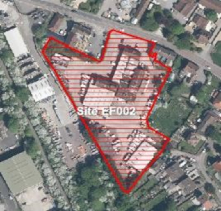
There are 2 potential options for allocation of this site – with fundamentally different land uses.
Option 1. Retain safeguarded employment land (CS12 designation).
The SGC Employment Land Review recommends safeguarding of existing CS12 sites with investment to improve their long-term employment viability
Option 2. Change to residential uses on part of the employment site has been proposed by landowners through the Call for Sites process.
Option 1. Continue to safeguard as Employment Area
Proposed use(s): employment
Capacity: TBC
Key site requirements:
- Employment Development should make the most efficient use of land to optimise the potential of this site
- Protect, enhance and provide Green Infrastructure and meet the requirements for Biodiversity Net Gain.
Option 2. Mixed use – Employment and Residential
Proposed use(s):
- residential
- employment
Capacity:
- residential – up to 10 homes
- employment – TBC
Key site requirements:
- Development should make the most efficient use of land to optimise the potential of this site
- Protect, enhance and provide Green Infrastructure and meet the requirements for Biodiversity Net Gain.
Land at Brereton Way (including Cowhorn Hill Depot) Tower Road South (2.45 ha)
Site reference: EF009
Call for Sites reference: SG843
Site plan:
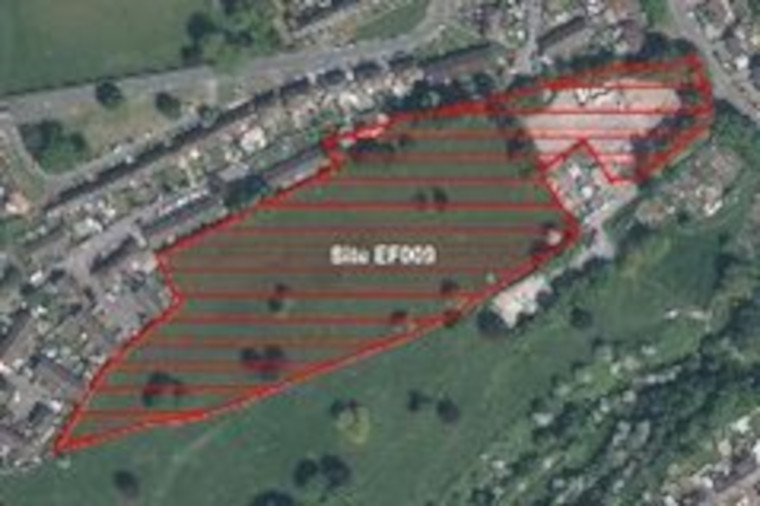
Proposed use(s): TBC
Capacity: TBC – The potential range of uses and capacity for this site will be determined through further public engagement
Key site requirements:
- Design in accordance with SGC urban lifestyle areas and density policy (draft) and principles to optimise density on site
- Protect, enhance and provide Green Infrastructure and meet the requirements for Biodiversity Net Gain.
The Grange School Warmley (12.23ha)
Site reference: EF013
Call for Sites reference: SG582
Site plan:
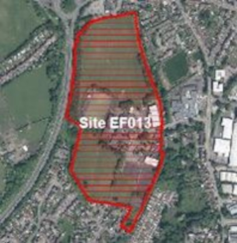
Proposed use(s): residential – with primary school and community uses
Capacity: up to 170 homes
Key site requirements:
- Development should make the most efficient use of land to optimise the potential of this site
- Retention or relocation of playing pitches
- Respect the setting of the heritage assets associated with Warmley Brassworks
- Protect, enhance and provide Green Infrastructure and meet the requirements for Biodiversity Net Gain.
.
General East Fringe Safeguarded Employment Areas – Parkwall and Warmley ward
The following sites are safeguarded for employment uses in the current Local Plan (Core Strategy Policy CS12). It is proposed that they continue to be a safeguarded employment areas in the new Local Plan. The sites below are within the East Fringe but sit outside any of the Urban Lifestyle Areas.
The sites below are within the East Fringe in the Parkwall and Warmley ward but sit outside any of the Urban Lifestyle Areas. The closest Urban Lifestyle Area is Kingswood. Please see the interactive map for further context.
- Site 13: Chapel Lane, Warmley (0.4ha)
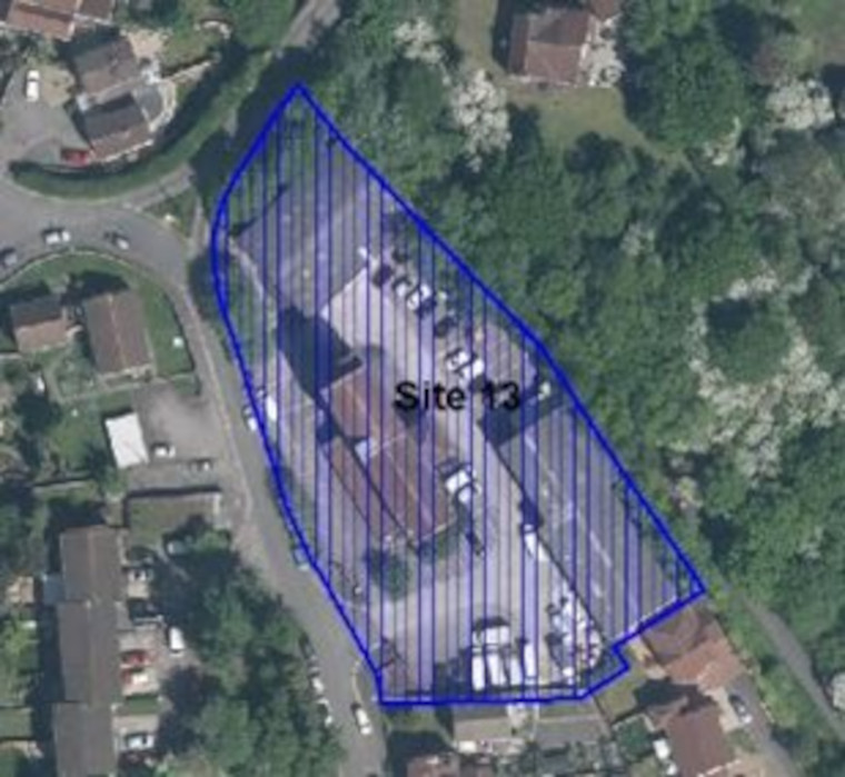
- Site 14a: Tower Road, Warmley – Eastern site (17.1ha)
- Site 14b: Tower Road, Warmley – Western site (2.5ha)
- Site 21: McBraida site (1.2ha)
The following area in the East Fringe Parkwall and Warmley Ward is also currently safeguarded for employment use in the Local Plan (Policy CS12) but have received Call for Site proposal for non-employment focused uses on part or all the existing employment area.
In this consultation we are therefore testing two options, either retaining as an employment safeguarded area or allocating for a different mix of uses.
- Site 28: 2-8 London Road, Warmley (1.4ha)
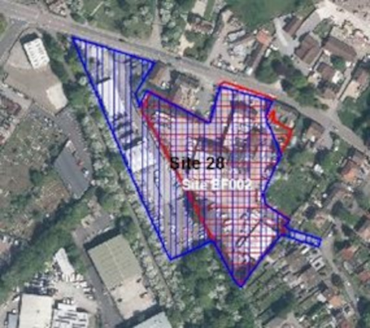
Potential Site Allocation Reference
Potential change to 0.5ha of the safeguarded employment area, at eastern extent. Please see proposed site allocation EF002 to understand more about the non-employment options suggested
General East Fringe Safeguarded Employment Areas – Bitton and Oldland Common ward
The sites below are within the East Fringe in the Bitton and Oldland Common ward but sit outside any of the Urban Lifestyle Areas. The closest Urban Lifestyle Area is Kingswood. Please see the interactive map for further context.
- Site 23a: Southway Drive (1ha)
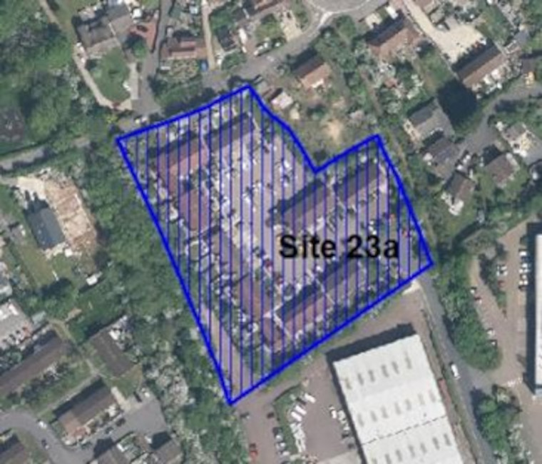
- Site 23b: Southway Drive, North Common – North (3ha)
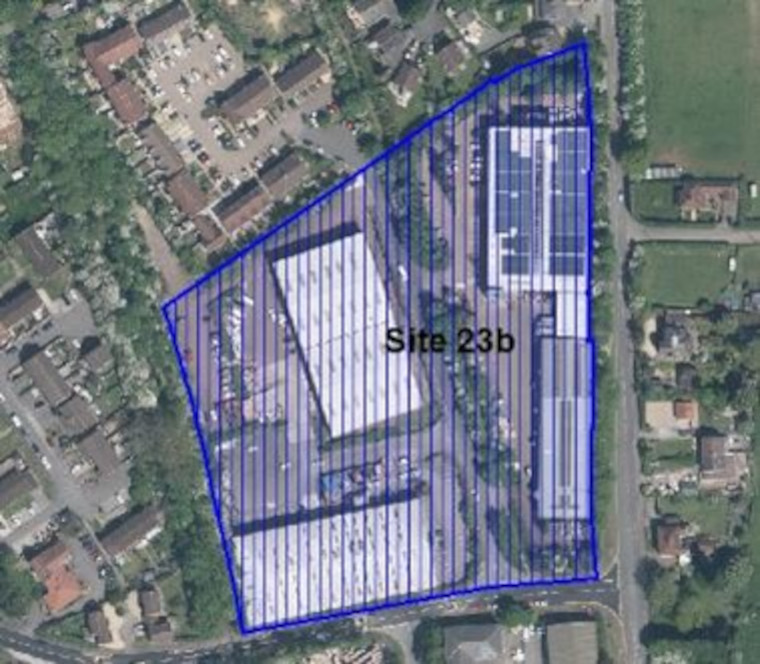
- Site 23c: Southway Drive, North Common – South (1.9ha)
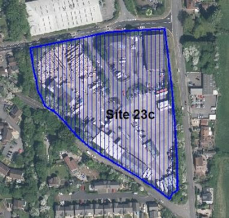
- Site 26: Bath Road, Willsbridge (1.1ha)
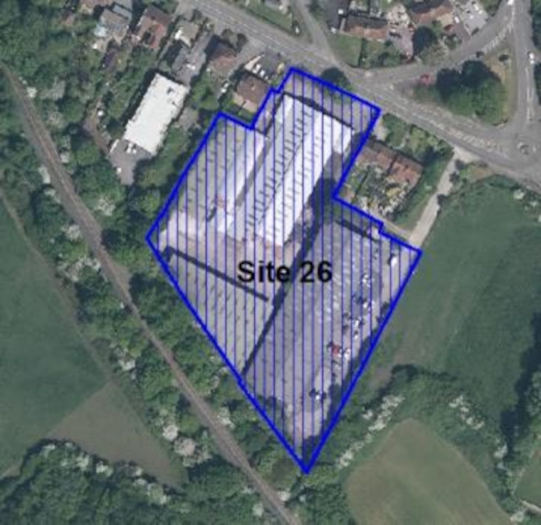
Yate and Chipping Sodbury
There are 4 areas of focus within Yate and Chipping Sodbury where there are opportunities to optimise the density of any new development and regeneration whilst respecting their existing Market Town character.
Below we have set out proposals for each of the areas within these communities where the higher density urban lifestyles approach will be applied.
At the end of the section we also identify sites within the remainder of Yate and Chipping Sodbury which we propose to allocate as redevelopment sites or continue to safeguard for employment. In these areas, which are less well connected to services and facilities, the general policies of the Local Plan will continue to apply.
In line with national policy, which requires us to look at previously used (brownfield) land first, we must consider options to redevelop sites within the boundaries of our Market Towns to provide the new homes and other types of development that we need. The majority of sites we are consulting on now have been suggested by landowners and developers through the Call for Sites process. It is important to note that this is the first stage of consultation on the potential site allocations. We are seeking your views at this stage and no final decisions have been made about changing the use of these sites.
Yate Town Improvement Plan
In addition to the Local Plan, work has been ongoing on the Yate Town Improvement Plan. This has been subject to extensive public consultation and was approved for publication by the Council in December 2021. A summary of the outputs of this masterplanning work are included below and masterplan proposals are incorporated into our area summaries where there is some certainty on proposed sites. Further details will be incorporated into the next phases of the Local Plan as appropriate.
The Yate Town Improvement Masterplan was developed over 2 years, working with partners. It will shape the future of Yate over the next 15-20 years and beyond by influencing decisions by private landowners and public sector organisations on investing and developing in Yate.
The plan builds on Yate’s existing character to make it an even more welcoming, healthy, sustainable, and prosperous place to live, work and visit. The approach taken puts people at the heart of the process and follows the “15-minute town” principles. The “15-minute town” is where daily necessities, such as work, schools, shops, healthcare and parks are within a 15-minute reach on foot or bike from home.
The final masterplan focuses on movement and green and blue infrastructure systems as well as 4 key areas in Yate. Together these will act as catalysts for the vision and ambition for the whole town.
The movement system vision – provides an opportunity to deliver a step change in the range of travel choices available to everyone who travels to, from and within the wider Yate area. This includes improving walking and cycling routes and facilities, redeveloping the rail and bus station, embracing new transport technologies, improving wayfinding and working with local communities in co-design of road space.
The Green and blue infrastructure system vision – refers to the natural spaces within Yate, including the River Frome, publicly accessible green space, amenity green space, natural and semi-natural green space, community gardens, outdoor sports facilities, and private green space. These spaces are valuable assets when they are part of a connected network, that provide a wide range of environmental and quality of life benefits for communities. There is an opportunity to improve biodiversity, connect habitats for nature, improve access to natural green and blue space and improve air quality.
Yate Town Centre – the vision for the town centre is for it to be a vibrant, inclusive, distinct and accessible pedestrian priority town centre. A gradual redevelopment of the town centre would include high quality open space, public realm and a mix of uses including housing and retail along with complementary facilities. It will also benefit from improved accessibility and connectivity with the wider surrounds and Yate Rail Station, including an upgraded bus interchange.
Yate Rail Station –The masterplan vision redefines the station from a ‘functional’ to a ‘living station’ with much greater emphasis on it as a place and destination in Yate, and provides an opportunity to encourage sustainable movement through a centre hub. There is an opportunity for the redevelopment of the train station to become a mobility interchange with improved links to the town, enhanced amenities and services, preserved heritage features and better connection to blue and green infrastructure. The masterplan vision is to consolidate the station on the south side of Station Road.
Western Gateway/Industrial area – there are opportunities to densify and diversify this employment area and add sustainable services and facilities as well as encourage sustainable travel and enhance green infrastructure in particular the River Frome corridor
Station Road – opportunities identified include working with local residents, businesses and community groups in a co-design approach, increasing off road parking, delivering a fully segregated and safe cycle route, upgraded bus facilities, reducing the number of HGV’s, developing opportunities for businesses to grow and attract new businesses and maximising opportunities for community facilities.
The Yate masterplan sets out design principles for the 4 focus areas and can be found at www.southglos.gov.uk/yatemasterplan.
.
Yate Shopping Centre
View this Urban Lifestyle Area on our interactive map.
Summary of proposed planning approach
Yate Shopping Centre is a popular and successful centre with a wide range of shops. There is a leisure centre, library and health and community services adjacent to the shopping area. Built in late 1960s, the shopping centre is 2-3-storeys high, with retail and public services that face inwards onto pedestrian walkways, and have limited residential accommodation above the shops. However, buildings and public spaces require investment, and there is a need to broaden the range of activities and uses during the day and evening, to maintain the vitality and role of the centre and significantly improve pedestrian access to the adjoining residential areas.
There are also a number of public buildings and areas that are low-density and offer potential for reorganisation and redevelopment to optimise densities and increase the mix of uses whilst maintaining the existing role and function of the town centre. This could include homes, leisure, recreation, community and employment development within town centre island. There is also potential in the main shopping areas for an increase in densities, and a greater mix of uses on upper floors. The Yate Town Improvement Plan has developed design principles for the town centre which include proposals to enhance the role of the River Frome in this area.
The shopping centre is owned and managed by a single landowner, and there are also a variety of public-sector landowners in the shopping-island area. This provides us with opportunities for a coordinated approach to regeneration and redevelopment.
In future this type of new development will managed in accordance with the Urban Lifestyles policy. Developments at the higher end of the recommended density range for the area will be suitable for the centre of the Urban Lifestyle area with developments at the lower end of the density range being more appropriate further away from the centre.
Appropriate density range
The appropriate density for this area will be 65-120 dph.
Future developments will be expected to fall in this density range, subject to meeting the requirements of the draft Urban Lifestyles and Density Policy. This sets out what would be required when developing a site in an Urban Lifestyles area to balance the investigation of higher densities with achieving high quality developments for people, places and the environment.
The location of a development site within an Urban Lifestyles area will be a key factor. As a starting point, subject to meeting the balancing requirements of the policy, sites which are very close to the centre of an area, near to shops, services and public transport options, would be expected to be developed around the upper level of the density range. A site which is located further away from the shops and services would be expected to be developed at a density towards the lower end of the range. Sites which are beyond 800m from a town centre or transport hub will generally fall outside of the requirement to investigate meeting the density range.
Potential site allocations
Please note that this is the first stage of consultation on this potential site allocation. We are seeking your views at this stage and no final decisions have been made about changing the use of these sites.
Site name, address and area (ha):
Select the plus icon for more information on each site.
Yate Shopping Centre (16.41)
Site reference: YA001
Call for Sites reference: SG816
Site plan:
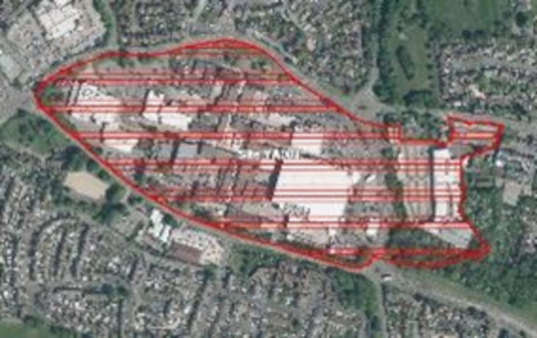
Proposed use(s):
- retail
- commercial
- employment
- community
- residential
Capacity: TBC through detailed masterplan
Key site requirements:
- Development should make the most efficient use of land to optimise the potential of this site
- Residential uses to be designed in accordance with SGC urban lifestyle areas and density policy (draft) and principles to optimise density on site
- Retain the retail and community role of Yate Shopping centre with potential to optimise land uses and improve public realm through future redevelopment
- Development to be in accordance with the principles set out in the Yate Town Improvement Plan
- Protect, enhance and provide Green Infrastructure and meet the requirements for Biodiversity Net Gain.
.
Safeguarded Employment Areas
There are no sites currently safeguarded for employment uses in this location.
.
Station Road, Yate
View this Urban Lifestyle Area on our interactive map.
Summary of proposed planning approach
Station Road runs from the station in the west to the shopping centre. It is of mixed character with offices, industrial, retail, residential and community uses. The buildings are mostly of two-storeys, with some elements of the heritage and character of the older settlement remaining. The route suffers from congestion and is an uninviting environment for walking and cycling. There is potential to increase density, subject to respecting the character and amenity of neighbouring uses. A comprehensive strategy is needed to achieve a shift towards more walking and cycling along this route and to provide design guidance to achieve maximum benefit from redevelopment. This would support the role of Station Road as a continuation of the town centre, linking the shopping centre and station, and achieve maximum benefit from redevelopment.
The variety of land uses and landowners means that redevelopment will happen in a piecemeal way over time. Future development will be guided by the Yate Town Improvement Plan and be managed in accordance with the Urban Lifestyles policy.
Appropriate density range
The appropriate density for this area will be 65-120 dph.
Future developments will be expected to fall in this density range, subject to meeting the requirements of the draft Urban Lifestyles and Density Policy. This sets out what would be required when developing a site in an Urban Lifestyles area to balance the investigation of higher densities with achieving high quality developments for people, places and the environment.
The location of a development site within an Urban Lifestyles area will be a key factor. As a starting point, subject to meeting the balancing requirements of the policy, sites which are very close to the centre of an area, near to shops, services and public transport options, would be expected to be developed around the upper level of the density range. A site which is located further away from the shops and services would be expected to be developed at a density towards the lower end of the range. Sites which are beyond 800m from a town centre or transport hub will generally fall outside of the requirement to investigate meeting the density range.
Potential site allocations
No sites are proposed for allocation for new development in this urban lifestyle area at this stage of the new Local Plan.
Safeguarded Employment Areas
There are no sites currently safeguarded for employment uses in this location.
.
Yate Station and surrounding area
View this Urban Lifestyle Area on our interactive map.
Summary of proposed planning approach
There is currently an hourly train service from Yate station to the North Fringe and Bristol city centre and to Gloucester, with planned, enhanced services to two trains per hour. This will help it to become a more attractive option than driving to access the North Fringe and Bristol city centre.
Optimising surrounding uses and the density of uses along Station Road to the shopping centre will help realise this highly-accessible area’s potential. The Yate Town Improvement Plan includes the investigation of potential approaches to improvements to the station and to make efficient use of the land on the industrial estates around the station. The vision is to consolidate the station to the south of Station Road and land will be safeguarded in future stages of the Local Plan as the business case for this is developed.
Future development will be guided by the Yate Town Improvement Plan and be managed in accordance with the Urban Lifestyles policy.
Appropriate density range
The appropriate density for this area will be 65-120 dph.
Future developments will be expected to fall in this density range, subject to meeting the requirements of the draft Urban Lifestyles and Density Policy. This sets out what would be required when developing a site in an Urban Lifestyles area to balance the investigation of higher densities with achieving high quality developments for people, places and the environment.
The location of a development site within an Urban Lifestyles area will be a key factor. As a starting point, subject to meeting the balancing requirements of the policy, sites which are very close to the centre of an area, near to shops, services and public transport options, would be expected to be developed around the upper level of the density range. A site which is located further away from the shops and services would be expected to be developed at a density towards the lower end of the range. Sites which are beyond 800m from a town centre or transport hub will generally fall outside of the requirement to investigate meeting the density range.
Potential site allocations
No sites are proposed for allocation for new development in this urban lifestyle area at this stage of the new Local Plan.
Safeguarded employment areas
The following sites are safeguarded for employment uses in the current Local Plan (Core Strategy Policy CS12). It is proposed that they continue to be a safeguarded employment areas in the new Local Plan.
- Site 29: Beeches Industrial Estate, Yate (9.4ha)
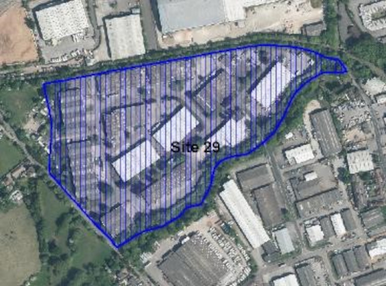
- Site 32: Council Offices, Badminton Road, Yate (2.6ha)
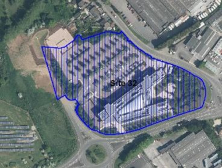
- Site 33: Great Western Business Park, Yate (33.4ha)
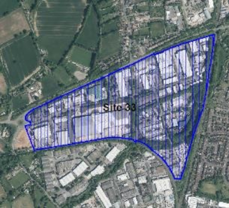
- Site 34: Indesit Site, Station Road (4.6ha)
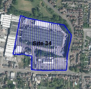
- Site 36: Westerleigh Business Park (22.1ha)
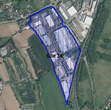
- Site 53: Badminton Court/Dairy Crest site (2.7ha)
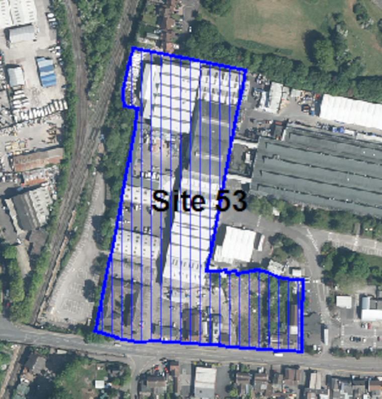
- Site 57: Stover Road and North Road Industrial Estates (17.9ha)
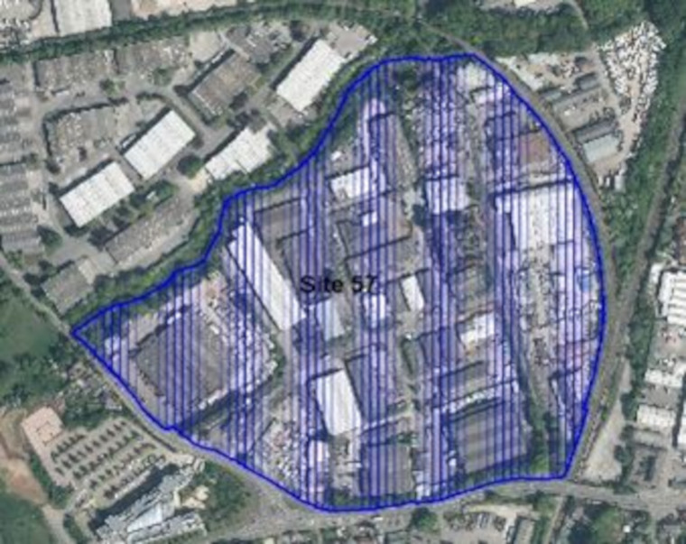
- Site 58: Badminton Road Trading Estate (11.1ha)
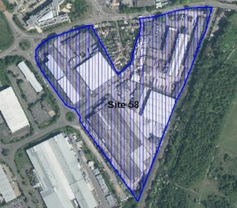
.
Chipping Sodbury Town Centre
View this Urban Lifestyle Area on our interactive map.
Summary of proposed planning approach
Chipping Sodbury is an historic market town with a range of key services and facilities centred on the historic town centre. It is located immediately to the east of Yate. Opportunities for further development in the town centre will be limited and focused on the potential redevelopment and regeneration of existing buildings and sites if they are brought forward by landowners.
In future this type of new development will managed in accordance with the Urban Lifestyles policy . This new policy will ensure that development makes the best use of land by optimising density whilst respecting the existing amenity and historic buildings and market town character of the High Street and surrounding areas.
Development should enhance the vitality and character of the town centre by:
- protecting and respecting the heritage, form and character of the historic town and its setting, in particular the conservation area and listed buildings
- supporting the regeneration and economic health of the town centre and community facilities within it.
- supporting investment in the provision of supporting infrastructure
- promoting walking and cycling links within the town, and to nearby open countryside and to services and facilities in Yate Shopping Centre.
- protecting key views into, and out of Chipping Sodbury, as well as landscape features and enhanced ecological networks
Appropriate density range
The appropriate density for this area will be 45-90 dph.
Future developments will be expected to fall in this density range, subject to meeting the requirements of the draft Urban Lifestyles and Density Policy. This sets out what would be required when developing a site in an Urban Lifestyles area to balance the investigation of higher densities with achieving high quality developments for people, places and the environment.
The location of a development site within an Urban Lifestyles area will be a key factor. As a starting point, subject to meeting the balancing requirements of the policy, sites which are very close to the centre of an area, near to shops, services and public transport options, would be expected to be developed around the upper level of the density range. A site which is located further away from the shops and services would be expected to be developed at a density towards the lower end of the range. Sites which are beyond 800m from a town centre or transport hub will generally fall outside of the requirement to investigate meeting the density range.
Potential Site allocations
No sites are proposed for allocation for new development in this urban lifestyle area at this stage of the new Local Plan.
Safeguarded employment areas
The following sites are safeguarded for employment uses in the current Local Plan (Core Strategy Policy CS12). It is proposed that they continue to be a safeguarded employment areas in the new Local Plan.
- Site 30: Bowling Hill, Chipping Sodbury (7.8ha)
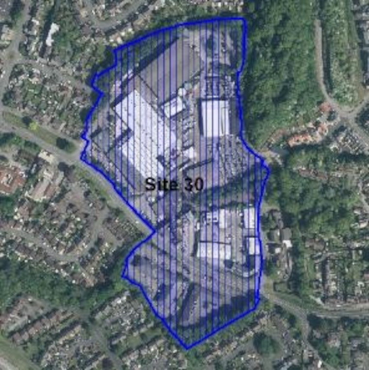
- Site 55: Hatters Lane (1.9ha)
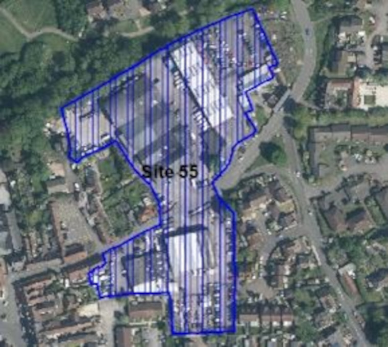
.
Remaining sites within Yate and Chipping Sodbury settlement boundaries
Below we identify a site which we proposed to allocate for residential development and a safeguarded employment area which are within the settlement boundaries of Yate and Chipping Sodbury but not within the urban lifestyles area. In these areas which are less well connected to services and facilities the general policies of the Local Plan will continue to apply rather than the draft Urban Lifestyles and Density Policy.
Potential Site allocations
The site below is located in the settlement boundary of Yate in the Yate North Ward but are outside of the Yate Urban Lifestyle Areas. Please see the online interactive map for further context.
Please note that this is the first stage of consultation on this potential site allocation. We are seeking your views at this stage and no final decisions have been made about changing the use of these sites.
Site name, address and area (ha):
Select the plus icon for more information on each site.
Field to south of Tanhouse Lane (opposite Leechpool Dairy Farm) (5.80ha)
Site reference: YA003
Call for Sites reference: SG010
Site plan:
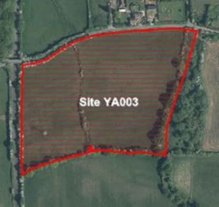
Proposed use(s): residential site within the North Yate New Neighbourhood allocation
Capacity: up to 130 homes
Key site requirements:
- Development should make the most efficient use of land to optimise the potential of this site.
- Development will need to take account of Pylons.
- Development will need to consider links/access from Tanhouse Lane and to the neighbouring NYNN site.
- Development should retain existing valuable hedgerows and Green Infrastructure and provide a suitable buffer between the development and adjacent countryside.
- Protect, enhance and provide Green Infrastructure and meet the requirements for Biodiversity Net Gain.
.
Safeguarded Employment Areas
The following site is safeguarded for employment uses in the current Local Plan (Core Strategy Policy CS12). The safeguarded site was given permission for residential through planning application PK14/4698/F. It is proposed that the site is removed as a safeguarded employment area in the new Local Plan. The site is within the settlement boundary of Yate but sits outside any of the Urban Lifestyle Areas.
- Site 56: Minelco Site/Yate Mills, Broad Lane (1ha)
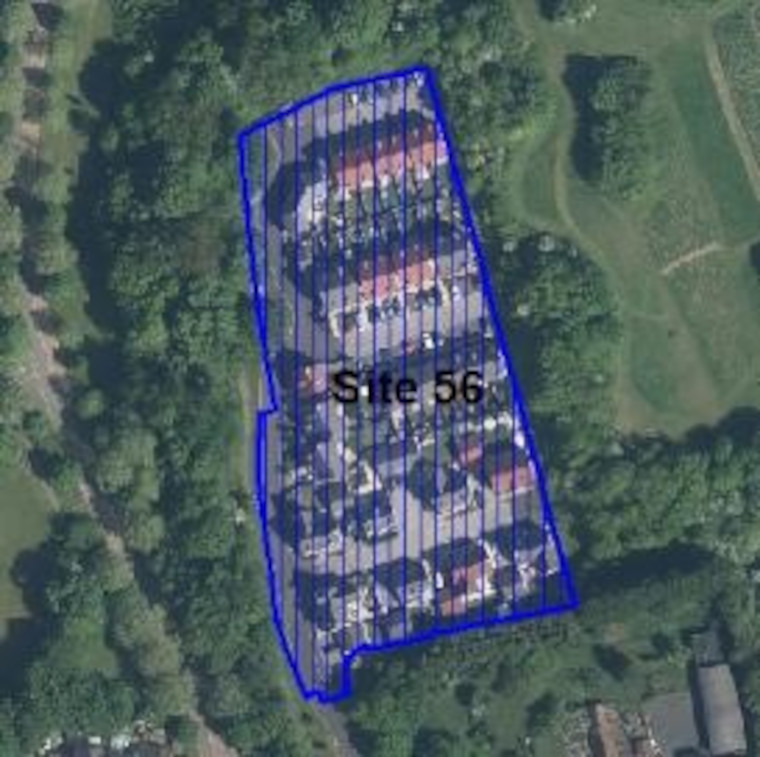
Thornbury
Thornbury town centre is an area where there are potential opportunities to optimise the density of any new development whilst respecting its existing Market Town and historic character.
Below we have set out proposals within a 10-minute walking distance of Thornbury town centre where the higher density urban lifestyles approach could be applied.
At the end of the section we also identify a site within the remainder of the town which we propose to allocate as a redevelopment site and sites which we propose to continue to safeguard for employment. In these areas which are less well connected to services and facilities the general policies of the Local Plan will continue to apply.
In line with national policy, which requires us to look at previously used (brownfield) land first, we must consider options to redevelop sites within the boundaries of our Market Towns to provide the new homes and other types of development that we need. The sites we are consulting on now have been suggested by landowners and developers through the Call for Sites process. It is important to note that this is the first stage of consultation on the potential site allocations. We are seeking your views at this stage and no final decisions have been made about changing the use of these sites.
.
Thornbury Town Centre
View this Urban Lifestyle Area on our interactive map.
Summary of proposed planning approach
Thornbury is an historic market town with a range of key services and facilities centred on the historic town centre. There are regular bus connections south to Bristol and north into Gloucestershire, as well as a network of local services to surrounding villages.
Opportunities for further development in the town centre will primarily be focused on the potential redevelopment and regeneration of existing buildings and sites if they are brought forward by landowners.
In future this type of new development will managed in accordance with the Urban Lifestyles policy . This new policy will ensure that development makes the best use of land by optimising density whilst respecting the existing amenity and historic buildings and market town character of the High Street and surrounding areas. Such development should also take into account the issues, vision and policies in the draft neighbourhood plan, as well as in national and local policies. Developments at the higher end of the recommended density range for the area will be suitable for the centre of the Urban Lifestyle area with developments at the lower end of the density range being more appropriate further away from the town centre and high street.
Development should enhance the vitality and character of the town centre by:
- protecting and respecting the heritage, form and character of the historic town and its setting, in particular the conservation area and listed buildings
- supporting the regeneration and economic health of the town centre and community facilities within it.
- providing new employment opportunities to help provide a better balance between local residents and jobs
- supporting investment in the provision of supporting infrastructure
- promoting walking and cycling links within the town, and to nearby open countryside
- protecting key views into, and out of Thornbury, as well as landscape features and enhanced ecological networks
Appropriate density range
The appropriate density for this area will be 50-90 dph.
Future developments will be expected to fall in this density range, subject to meeting the requirements of the draft Urban Lifestyles and Density Policy. This sets out what would be required when developing a site in an Urban Lifestyles area to balance the investigation of higher densities with achieving high quality developments for people, places and the environment.
The location of a development site within an Urban Lifestyles area will be a key factor. As a starting point, subject to meeting the balancing requirements of the policy, sites which are very close to the centre of an area, near to shops, services and public transport options, would be expected to be developed around the upper level of the density range. A site which is located further away from the shops and services would be expected to be developed at a density towards the lower end of the range. Sites which are beyond 800m from a town centre or transport hub will generally fall outside of the requirement to investigate meeting the density range.
Potential Site allocation
Please note that this is the first stage of consultation on this potential site allocation. We are seeking your views at this stage and no final decisions have been made about changing the use of these sites.
Site name, address and area (ha):
Select the plus icon for more information on each site.
Thornbury Health Centre, Eastland Road, Thornbury (0.42)
Site reference: TH006
Call for Sites reference: SG856
Site plan:
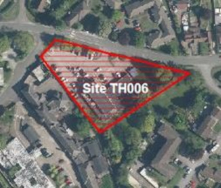
Proposed use(s):
- retain health clinic
- residential
Capacity:
- retain health clinic – 2000m2
- residential – up to 15 homes
Key site requirements:
- Retain and enhance health clinic on site in existing or redeveloped building.
- Development should make the most efficient use of land to optimise the potential of this site.
- Design in accordance with SGC urban lifestyle areas and density policy (draft) and principles to optimise density on site.
- Protect, enhance and provide Green Infrastructure and meet the requirements for Biodiversity Net Gain.
.
Safeguarded Employment Areas
The following site is safeguarded for employment uses in the current Local Plan (Core Strategy Policy CS12). It is proposed that it continues to be a safeguarded employment area in the new Local Plan.
- Site 37: Thornbury Industrial Estate (18.1ha)
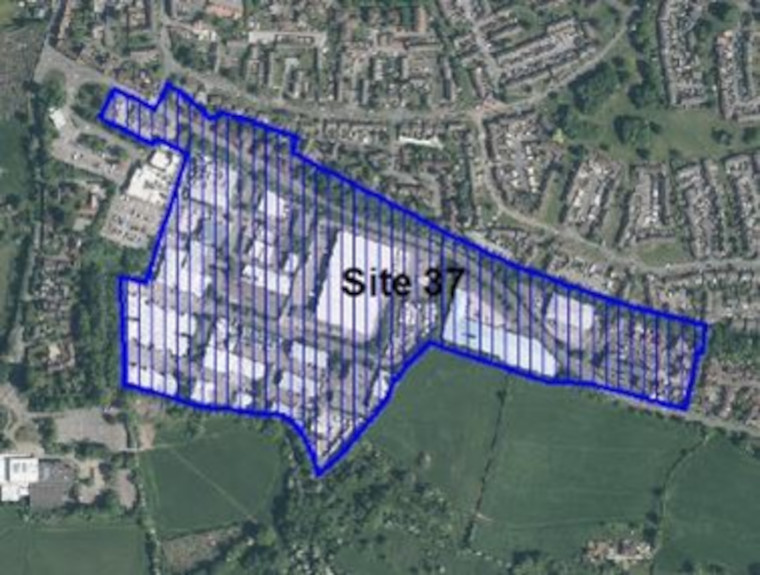
Read the next chapter – Creating sustainable rural villages and settlements
Go back to the Local Plan 2020 – Phase 2 Urban, Rural and Key Issues document landing page.