Local Plan 2020 Phase 1 consultation
The aim of this section is to describe how we may approach the provision of increased levels of growth and development while creating a high quality of life in our urban areas.
This proposed new approach to development in some of our urban areas is called Urban Lifestyles. The COVID-19 pandemic and its impact on our lives has shown how important it is that our main urban areas and town centres are vibrant, healthy and safe places that provide good access to open spaces, public and private gardens and clean air. The COVID-19 pandemic has also shown us that the type and size of our homes has a major impact on our wellbeing too. Seeing how our communities have been impacted by COVID-19 has given us a renewed commitment to develop a new, better, local, place-based, approach, built around our local communities.
Part 1 presents information on the background to the Urban Lifestyles approach, why it is needed, what it means, what it may look like and where it may be appropriate.
It is presented in six parts and covers the following discussion topics:
- Introduction
- Why is South Gloucestershire Council developing an Urban Lifestyles approach?
- How is Urban Lifestyles different to the existing approach?
- What would an Urban Lifestyles development look like?
- Urban Lifestyles – which Locations?
- Areas of focus, sites and change
Part 2 presents information on the key places where we think this can be most effective at supporting further development that promotes our commitment to sustainable Urban Lifestyles. We identify 14 places where we think an Urban Lifestyles policy approach could be appropriate.
This is focused on the most accessible locations in and around our designated town centres, rail stations and transport hubs:
- Communities of the Bristol North Fringe
- Cribbs / Mall, former Filton Airfield, Patchway Town
- Centre, Bradley Stoke Town Centre, Filton Town
- Centre, Parkway Rail Station to UWE
- Communities of the Bristol East Fringe
- Kingswood, Staple Hill, Downend, Emersons Green, Hanham, Longwell Green
- Yate
- Thornbury
Part 1: Background: why, what, where and future work
Our new Local Plan must demonstrate that we are making the most effective use of land – particularly on brownfield sites to support the new homes, jobs and infrastructure that we will need.
This means we must investigate new approaches to how we live, and how urban areas are developed. We must be able to achieve growth and change that is sustainable and of a high quality. We should also avoid significant impacts on the environment and quality of life for people living in, working in, and visiting urban areas.
‘Urban Lifestyles’ is the term we’ve given to how new approaches to change and growth in our urban areas is investigated and delivered. Urban Lifestyles aims to make the best use of sites that are made available for development or repurposing and promote better use of land in the most appropriate and sustainable urban locations. This development must be well-designed and built to a high standard.
Urban Lifestyles also allows us to consider how we might provide a range of different uses for available sites and land. This range of uses should not just include places for people to live, but should also include employment opportunities, leisure activities, cultural facilities and shops. By applying a range of mixed uses, we can create vibrant destinations and offer an enhanced experience for residents and visitors, and increase the amount of people who live in, work in, and visit our urban areas. Particularly, our high streets, town centres and major urban centres, which we can help to make more sustainable, and make sure that they thrive in the future.
The character and context of our existing urban areas should inform the level of development appropriate for individual areas and sites, and avoid negative impacts on people, character and assets in urban South Gloucestershire. Levels of walking, cycling and public transport access to key services and facilities will also inform where, and to what extent, greater levels of development can take place. Promoting and supporting these forms of sustainable travel is a key component of the Urban Lifestyles approach.
To ensure high-quality and positive change in our urban communities throughout our new Local Plans period and into the future, new forms of planning policies are needed, and in some places, we will also need detailed master plans. The Urban Lifestyles approach will inform these changes.
Why is South Gloucestershire Council developing an Urban Lifestyles approach?
Our urban areas have a range of existing issues and new challenges, and opportunities will be created by the need for greater levels of development and change in our urban areas. This has been clearly demonstrated to us by the COVID-19 situation, and our response needs to be clear, ambitious and capable of introducing lasting transformation.
National Planning Policy Framework (in particular, paragraphs 122 and 123) requires that our new Local Plan, and future development of urban areas, must increase the density of development, by making efficient use of land in sustainable urban locations. This approach can also help to reduce the pressure to build on greenfield land and presents an opportunity to reinvigorate urban areas.
The National Design Guide, a government document setting out how we should plan areas, supports well-designed, new development that makes efficient use of land, with an amount and mixture of development and open space, that optimises density:
- in this document we use the phrase ‘optimising’, when we refer to increasing the level of development and density on appropriate sites
- optimising development, means making efficient use of land through balancing a higher density of development with quality of life and environmental factors, to create well-designed living environments that are appropriate and suitable for the location
There are poorly designed developments and spaces in South Gloucestershire that fail to make the most effective use of urban and brownfield land:
- this includes low-density housing estates and campus-style business parks, underused areas, vacant sites, back-land parking and garaging sites, and leftover spaces
- while these are a product of their time, they do not optimise land and could provide opportunities as they become available for development
Issues and opportunities
While we need to optimise density and make sure future plans and developments make more efficient use of land, we need this to be focused in the right urban areas. We also need to make sure that we have new planning criteria to avoid overdevelopment and negative impacts on people and the built and natural environment.
The following issues and opportunities are important to consider:
Issue 1: limited access, amenity and overspill impacts
- greater levels of development in urban locations that lack walking, cycling and public transport access to key services and facilities, which can lead to an increase in car travel
- optimising density, and greater levels of development, can potentially increase issues of overlooking, or the failure to provide high-quality private and public realm spaces, or access to open space, as well as the potential for greater disturbance from noise and air pollution
- poorly planned development can lead to an increase in ‘overspill’ problems, like poorly controlled on and off-street car parking, inadequate bin storage and can also contribute to a poor living environment, including antisocial behaviour
Opportunity:
Optimising the density of developments must maintain an area’s prevailing character and setting, and provide well-designed, attractive and healthy places:
- higher densities in the right locations can make public transport systems more viable, because more people, who may want to use the services, can be served by these transport systems and services
- sustainable travel options, like walking and cycling, are a critical part of the Urban Lifestyles’ approach and, become far more appealing when people live closer to shops and services, like near high streets and town centres
- on housing sites where density is optimised, the provision of good, readily accessible amenity spaces like balconies, public areas and open spaces should be included
- good-sized and comfortable apartments and houses, with low running costs and low-carbon energy consumption, are a key focus — while appreciating and respecting local built character and heritage assets
Issue 2: connecting open spaces and landscapes
There are some poorly connected or maintained open spaces, which can lead to them being underused. There are also ongoing issues to protect or improve the network of street trees and canopy cover. This affects enjoyment and wellbeing in the public realm, high streets and town centres, as well as people’s ability to access high-quality open spaces.
Opportunity:
- providing access, views and integration of open space, green assets, and connections to the surrounding countryside from the urban area, will become increasingly important with more people and development requiring strong networks of green infrastructure for people and wildlife
Issue 3: traditional, existing housing stock
The existing urban areas of South Gloucestershire are made up of largely traditional housing, with a mixture of Victorian, 1930s and 1940s suburban housing, and more recently, housing estates in Bradley Stoke and North Yate, as well as mixed-use developments at Lyde Green and Charlton Hayes.
Opportunity:
- to increase the diversity and choice that is suitable for different families (like single, first-time buyers and older people) we have an opportunity to balance our existing housing stock with new styles and forms of housing, like apartments and shared types of accommodation.
Issue 4: inequality and deprivation
The decline in the status of several of our urban communities, evidenced by underperformance in terms of economic activity and quality of life, has led to an increasing levels of inequality and deprivation in some urban areas.
Opportunity:
- plans for development, investment and change, present an opportunity to contribute to addressing inequality in our urban areas.
- to effect the change needed in some of our urban areas, working in partnership will be needed, along with potential master planning and regeneration initiatives — as well as a unified Council and partners approach in urban areas, and across all policy areas
Issue 5: loss of safeguarded employment land
Over the last 10 to 15 years, there has been a steady loss of safeguarded and non-safeguarded employment land, mostly to housing in the East Fringe of Bristol. This has led to an imbalance of workers to jobs, and the need for long commutes, with less opportunity to walk or cycle to employment areas.
Opportunity:
- as we plan for the future of our urban areas, it’s important we ensure a balanced approach to the growth of new homes, with provision of employment land in our urban areas, potentially, for mixed-use development types
- we must also make sure that our remaining employment sites become more flexible and adaptable, and are set in a high-quality environment, to attract investment and opportunities from a range of business sectors and types
Issue 6: changing shopping habits
Over the past decade, we’ve witnessed significant changes in the way people shop, and these changes are likely to continue in the future. Increased online shopping and the decline of the high-street retail sector is having a significant negative impact on the viability of the traditional uses of our town centres.
Opportunity:
- a wider range of activities, uses, and more people living and working within easy walking distance of existing town centres, will bring increased footfall to retailers and businesses, and could help to justify the provision of new community facilities
- this will improve the viability of traditional town centres and high streets, while also giving them a new purpose and role in our communities over the coming years
- the public realm is an important part of any shopping experience – an attractive and safe space for pedestrians can produce an increase in footfall, dwell-time and spending
Issue 7: car use
High levels of car use, particularly to access employment opportunities and other key services, is leading to increasing pressures on the transport network, and causing significant problems with congestion, poor air quality, as well as inequality of access for some urban communities. The need for private car use also drives a need for higher levels of car parking, which takes up valuable development land. Instead, this could be used for enhancing areas in the public realm, green infrastructure and other key services and facilities. We may see private car use begin to decline during our new Local Plan period. If alternatives become more readily available and cost-effective, our Plan may need to consider flexible policy approaches.
Opportunity:
- There are a variety of alternative ways to deal with parking, including below buildings in basement levels, or within the footprint of the building at ground level as undercroft parking – these alternative approaches should be investigated as part of the new approach
- An Urban Lifestyles approach promotes high levels of walking, cycling and public transport use, and benefits air quality, health, and the climate emergency — making better use of urban sites reduces the pressure on greenfield sites to meet housing needs
- The linked issues of air quality, health and wellbeing, and the climate emergency, will need to inform the way in which urban developments are designed — a cleaner and more appealing living environment will enhance everybody’s quality of life
New Urban Lifestyles themes
Existing policies in the ‘Core Strategy and Policies Sites and Places Plan’ guide the approach to development of our urban areas. Our policy approach to issues like design, open space, green infrastructure, parking, density, and mixed-use are applied across the whole district, rather than in a specific way in individual urban locations. We will need new planning policies to guide planning applications that come forward for development, and set out a strategy for investment, change, master planning, and the development of our urban areas, in the coming years. There are a few key changes that the new Urban Lifestyles approach aims to introduce into our new Local Plan and the supporting master plans.
Theme 1: Optimising density and making efficient use of land
In appropriate areas and on the right sites, optimising the density of development will be investigated. In most cases this means that there can be more housing and jobs, at a level that is higher than in the surrounding area:
- Rather than a single density figure, which would be an inflexible and insensitive approach, to apply to the different urban communities of South Gloucestershire, each location where an Urban Lifestyles approach is adopted, will be given its own density range, based on how accessible that place is, and the existing character of the area
- Information collected through this consultation and separate characterisation studies will be used to inform what an appropriate density range for each area should be
Optimising density will lead to an increase in the number of people, homes and jobs in some areas, particularly if much of the surrounding area is composed of lower-density housing, single-storey shops or low-level business parks, and single-storey warehouses.
Optimising density does not mean tall tower blocks — it means developments that are appropriate, and relate well to the built forms in the area, including a range of types and sizes of development, and uses:
- for residential development, this can mean more of a focus on the provision of apartments, rather than detached and semi-detached houses
- apartments can offer a more efficient use of limited development land, and can provide flexible living environments for a wide range of residents.
- this approach can benefit downsizers and younger residents who want to get into the property market by renting or buying their own homes
- apartments also offer better value for money, when compared to buying or renting larger properties
- apartments often require less ongoing maintenance and generally do not have flights of stairs as they are normally designed on a single level — this can make them a more accessible option for a range of potential residents
Theme 2: mixed uses
Key urban sites often need to make provision for a mixture of uses, particularly on the high street and, where redevelopment of employment land is taking place. This is to ensure that jobs, homes, businesses and key services are provided, either on different parts of the site or, for example, living spaces above shops, businesses and community facilities like libraries. Mixing uses can have significant benefits for safety and activity, where people are actively using a development throughout the day and into the evening. Where an office or shop would attract people during the daytime, the apartments and houses would promote activity later in the day and into the evening, when shops and offices are closed.
Theme 3: private amenity spaces and public realm
New approaches to ensure a minimum level of private amenity spaces, like useable balconies, small private gardens, and well-designed, accessible, public and private communal spaces will be needed on sites where densities are optimised. This will help to contribute towards positive living environments for residents, but will require clear approaches and responsibilities with regard to long-term management.
Because an Urban Lifestyles site might be developed with more buildings, it is important to make the areas surrounding the properties as appealing, usable and safe as possible. There will be an additional focus on the quality of the public realm that surrounds and supports these buildings. These spaces must be well-designed and landscaped and finished to a high standard with high-quality materials. Safety and security are also key factors, and areas in the public realm must be safe, in terms of perceived and actual safety, with good lighting and limited opportunities for antisocial behaviour.
Theme 4: internal living space size
New Urban Lifestyles’ developments will be required to meet minimum acceptable internal sizes, referred to as the Nationally Described Space Standard. This standard is currently only applied to some types of affordable housing. It is proposed to apply this to all types and tenures of residential dwellings:
- this will ensure that every home has sufficient space for comfortable living, including functional bedroom sizes, living areas, and plenty of room for storage
- the COVID-19 pandemic has demonstrated that space that allows for comfortable home-working is a key consideration
- we must ensure that any communal areas are a good size and are well-lit by natural light
- Urban Lifestyles’ developments must provide enough space to allow the easy sorting and storage of different recycling or waste containers
- a focus on communal recycling areas and spaces should also be made, for some apartment buildings and large housing developments
Theme 5: adaptability, views and natural light
Urban Lifestyles’ developments will need to be adaptable, over time, to allow people of different ages with differing needs, to live in, and use them. Mixed-use sites that can accommodate a variety of uses and functions will be encouraged, in certain areas and on certain sites.
Natural daylight and views are important to consider. New Urban Lifestyles’ developments must consider light levels by providing comfortable natural light, while limiting south-facing, and excessive, direct sunlight. Views from larger living room windows are a key aspect of higher-density approaches, as well as making sure that properties face in more than one direction, to aid natural ventilation of internal spaces.
Theme 6: reduced car parking
The level of car parking required, and how parking is managed will need to be altered. Because Urban Lifestyles’ areas and development sites will be close to existing high streets, town centres, rail stations, major destinations and facilities on significant public transport routes, and the strategic cycle network in the North and East Fringe, a lower level of parking is considered appropriate.
Lower levels of car parking can mean that more of the site can be utilised for new development, open space, public realm and more focus on secure and covered cycle and motorbike parking, with shared private vehicles (e.g. car clubs) being more of a focus.
- a new parking policy (to eventually replace PSP16) is being developed in parallel with the new approach to Urban Lifestyles. This will include specific guidance that relates to potentially reduced car parking requirements, on appropriate Urban Lifestyles’ sites and areas
What would an Urban Lifestyles development look like?
It would be designed to optimise density, when compared with the surrounding built-up area, which, in some cases could mean a slightly larger building type, or a different arrangement of buildings on site.
In town centres, and where employment opportunities, or services and facilities like healthcare, libraries and community facilities are required, it would aim to provide a variety of uses, all designed to interact. This would provide opportunities for working and living in, as well as space for key services and facilities.
- Well-designed, to sit comfortably within the existing context, and respond to features in the local area, like valuable landscape features, key views and vistas of landmarks and the surrounding rural areas and landscapes. This type of development should be well-connected to existing streets and provide easy access to surrounding areas.
- Reduced car parking provision would be better integrated into the design of development, where appropriate, and where overspill can be managed. Increased bicycle and, possibly, motorbike parking options, would be an important part of any Urban Lifestyles’ development.
- A diverse range of living accommodation and property types would be considered, depending on the size of the site, to cater to a range of potential residents.
- Minimise impacts on existing residential properties in surrounding areas, with regard to any overshadowing (blocking of sunlight) and overlooking from windows and balconies, to ensure appropriate levels of privacy.
- Every property would have access to some form of private amenity space, like a balcony for apartments, or garden space for houses. This would allow residents to sit outside or play in the open air, hang up clothes to dry, or grow plants.
- More activity on the streets, and more surveillance across the public realm, from windows, balconies and the front of properties would be created. Safe, secure and well-lit amenity areas will be a key feature, to allow residents to enjoy spending time outside in their local area.
- The public realm, including open spaces, will be well-designed and offer places that allow residents to enjoy being outside. It will focus on high-quality landscaping, materials, and green infrastructure, including planting and paving areas.
Urban Lifestyles – locations and criteria
Development in our urban areas has been taking place for some time, and will continue to take place into the future. Our existing ‘Core Strategy and Policies Sites and Places Plan’ includes the policies for key sites in the urban area. We also have policies that cover the whole authority. But, our existing policies require the same approach to issues like design and parking, and amenity space across the area. We are proposing different policies, approaches and requirements in certain urban areas where an Urban Lifestyles’ approach to development might be adopted.
However, not everywhere in urban South Gloucestershire will be appropriate for the new approach. An Urban Lifestyles’ development will need to be near to key facilities and services, to allow walking and cycling, ideally on the strategic cycle network. It should also have high quality, frequent public transport connections to major destinations. It will need to be appropriate to the local character context and avoid doing harm to the built and natural environment.
We hope to propose the investigation of Urban Lifestyles’ approaches in locations that are:
In and around town centres and high streets
Our town centres offer great opportunities to access a range of facilities and services by walking and cycling. They also provide public transport connections to a wide range of locations. Maximising the opportunity and attractiveness of walking, and using cycling routes, has environmental benefits and significant public and physical health and wellbeing advantages for residents.
Everyone has different capabilities, and some residents may not be able to walk or cycle as far as others can. We think that between 800 metres and 1km (a 10-minute walk) is an appropriate distance to consider for how long it might take to access existing shops and services, and where Urban Lifestyles development might be appropriate.
Surrounding rail stations and public transport hubs (outside of town centres)
The Urban Lifestyles’ approach of optimising densities can also be appropriate when people need access to high-quality, frequent public transport connections that access key services and facilities, and employment opportunities. Because of this, Urban Lifestyles will be investigated in and around rail stations and public transport hubs at Cribbs Causeway and the University of West of England (UWE). Development and regeneration in these locations offers opportunity to enhance the rail stations and transport hubs.
Cribbs Causeway and UWE, offer existing employment opportunities and some other facilities, they also provide a large number of public transport connections, including Metro Bus links to locations that meet a wide range of needs, like our town centres, Bristol city centre and further afield.
Suitable for the local context and character
In addition to having a high level of sustainable access to key services and facilities, Urban Lifestyles’ developments will need to respond to the context of each urban location, be delivered to a high quality, and avoid harm to the existing character and built and natural assets, of an area. It’s important to consider that each of the potential focus areas, like town centres, are different in various ways, with differing accessibility levels, characters, built forms and landscapes. Because of this, the approach to optimising development sites in each area will be slightly different. To assess the character and density of each area, we intend to carry out a series of characterisation studies.
We are developing a series of design criteria, against which any Urban Lifestyles’ development will be assessed. The design elements include private amenity space for all properties, minimum-space standards, and a new approach to parking provision, as key requirements. A greater emphasis on the quality of the public realm is another important issue, with a focus on high-quality materials and landscaping. These requirements will need to be met, in addition to being in an appropriate location for services, facilities and public transport.
Areas of focus, sites and change
Achieving the Urban Lifestyles’ vision will require a shift in future residents’ and workers’ expectations, and different delivery models, to focus on creating optimised urban developments, and the structure and character in appropriate parts of the district. This will require inspirational leadership to articulate bold ambitions and coordinate the actions of those who can play a part in delivery, potentially including new public investment.
To implement this new approach in appropriate urban locations, there are a number of ways development could be guided and happen. There will be a mixture of areas that are subject to change. Some of these areas may have bespoke new Local Plan policies and supporting detailed master plans. There are a number of individual sites we know about that we can allocate for Urban Lifestyles’ development and set key criteria for. There is also development that will be available in the coming years — this will need to be considered against the planning policies that cover the Urban Lifestyles approach.
The Local Plan will need to:
- identify key Urban Lifestyles’ areas, and then, sites for change through renewal and reuse – like better uses of existing employment sites, so that these can be redesignated for mixed use (e.g. a combination of new business premises and homes)
- consider areas for detailed master planning, where development and regeneration of wider areas is the subject of focused partnership working, to bring about Urban Lifestyles’ development, regeneration, and area enhancement
- develop new policies to deal with optimising density, design, parking, private and public spaces, open spaces, and other issues that require a bespoke approach in Urban Lifestyles’ areas
- identify opportunities for investment in our historic assets, public realm, open spaces and urban tree stock — so these existing assets, new open spaces, streets and transport routes become more pleasant places to be, while encouraging economic investment in walking and cycling
- identify the community services and facilities that would be required to support development, and how these would be delivered
Part 2: Urban Lifestyles suggested locations
This section looks at the urban areas of South Gloucestershire in the North and East Fringes of Bristol, as well as the towns of Yate and Thornbury.
The Core Strategy has a vision and policies for each of these locations (Policies CS25-CS33). We will need to review and update these policies to allow for the Urban Lifestyles’ approach, as well as for any key sites, new transport schemes, new strategies and projects, such as Green Infrastructure or transport schemes, and any detailed approaches developed through master planning.
We begin by setting out the key characteristics of each of these places, and the issues that the new Local Plan strategy and policies should focus on addressing. There will continue to be development and change in each of these urban areas, and new Local Plan policies will be applied to assess and drive high-quality development. We seek your views on whether these are the right issues for each place, so that we can develop the correct local strategies and policies.
Having established the importance of the new Urban Lifestyles’ approach, and what this might look like in practice, we also want to provide more information about the places in each of these areas where an Urban Lifestyles’ policy approach might be appropriate. This is focused on the most accessible locations in and around our designated town centres, rail stations and transport hubs.
We’re interested in your views on our choice of Urban Lifestyle locations, and the issues and opportunities of each. We’d also like to know about potential development sites and other key issues in your community that we should consider when planning its future, for the next 10, 15 or 20 years and more.
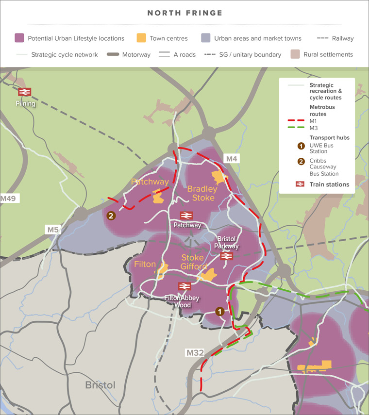
Communities of the Bristol North Fringe
The North Fringe of the urban area of Bristol in South Gloucestershire includes the communities of Cribbs Causeway, Filton, Patchway, Bradley Stoke, Stoke Gifford, Harry Stoke and Frenchay. The issues and opportunities that relate to the North Fringe and potential Urban Lifestyles’ locations are set out below.
Local communities, housing, services and facilities
The area has developed as a series of distinct communities with a number of mainly suburban developments from 1930s –1990s. Significant new housing developments have been recently completed at Charlton Hayes and Cheswick Village and more are planned within the new neighbourhoods at Cribbs Patchway (on the old Filton Airfield) and at Harry Stoke, increasing the size of the local population. There have been difficulties in the past with providing supporting infrastructure such as schools, public transport and community buildings at the right time, ahead of or alongside the development of the new homes. Integrating old and new communities and ensuring that the benefits of growth and investment are felt by all communities is important. There are increasing levels of inequality in some areas, with higher levels of unemployment and deprivation, partly due to changes in employment in the area in recent decades.
There are both further and higher education facilities within the area at South Gloucestershire & Stroud College’s Wise and Filton campuses and the University of the West of England’s main campus. However, there are ongoing capacity issues at SGS College which will need to be addressed as the local population increases. The urban area of the North Fringe is developing as a tourism destination with the completion of the Aerospace Bristol museum and a planned major new arena complex in the historic Brabazon Hangar at Filton airfield. There is also a cinema and leisure complex at the Mall and leisure centres at Filton and Bradley Stoke. These complement significant attractions in the rural areas adjacent to the North Fringe – Bristol Zoo’s Wild Place and the Wave surfing lake.
Town centres and retail areas
There are a number of designated town centres and retail parks throughout the North Fringe. The Mall and surrounding retail parks also provide significant retailing and leisure facilities. However, some of the town centres require investment and regeneration to provide a better range and quality of uses, including living opportunities and improvements to the public realm, and open spaces as well as links to stations and centres of employment and education. In particular, the area between the MOD and Stoke Gifford does not maximise potential for optimising the density of development, or the range of land uses offered by the accessibility of nearby public transport corridors and the rail stations at Parkway and Filton Abbey Wood.
Transport and accessibility
The North Fringe benefits from excellent rail, public transport and road connections. Bristol Parkway rail station provides links to Bristol city centre, London and South Wales, benefitting from electrification of the mainline. There are two further local rail stations at Filton Abbey Wood and Patchway. Further investment in rail is planned, including improvements to Parkway rail station, the opening of the Henbury Spur freight line to passenger services and two new rail stations at Henbury and North Filton. Metrobus services connect North and East Fringes to Bristol city centre and South Bristol, with the planned Metrobus extension from Parkway to The Mall via Cribbs Patchway New Neighbourhood currently under construction.
There is a good network of local bus services and significant public transport hubs at Cribbs Causeway and UWE, which have national services, Metrobus and local connections connecting at their bus stations.
The North Fringe has direct access to the M4, M5 and M32 motorways, and is crossed by the A38 and A4174 ring road. The area has a good network of strategic, off-road cycle routes. In particular, the ring road path and Concorde Way offer good connections to major employment opportunities at the North Fringe, Bristol and Bath Science Park, and Bristol city centre. However, roads, rail lines and large campus-style developments with limited permeability, are a significant physical barrier to walking and cycling movement in the area. The pedestrian links around the rail station to existing town centres and employment areas could be enhanced too. Walking can be made less attractive by the sometimes-long distances between destinations, the proximity to major roads, limited crossing facilities and poor design of pedestrian routes. There is a need to plan for, and provide, fully connected local and strategic, walking and cycling routes into and through the area. We should also build on the potential of the existing network of cycle and walking connections, to help address climate change, congestion and quality-of-life issues.
Environment and green spaces
The most extensive local green space is historic Stoke Park, which lies to the south, and mostly in Bristol City Council’s area. There are a variety of small local parks and informal green spaces throughout, and these could benefit from further investment to better meet the needs of local communities, as well as provide more opportunities for wildlife. Limited pockets of wildlife habitat and landscaping are fragmented across the area. In particular, the mature planting around the roads and campus-style employment areas, and along the railway lines provides the main green asset in much of the North Fringe. These should be protected, connected and reinforced to provide further benefits for local amenity and ecosystem services, as key sites are developed. Investing in Green Infrastructure connectivity in the area, including links out to the open countryside and beyond the motorway network, will play an important role in sustaining the optimised urban densities and their promotion.
Employment and commuting
The North Fringe is one of the most economically important areas in the south west and includes a number of significant employers and academic institutions. These include the aerospace cluster at Filton, significant numbers of office and service businesses around Aztec West, and high-tech advanced-engineering industries around UWE, that connect to the Bristol and Bath Science Park at Emersons Green (in the East Fringe).
Because of this, there are almost twice as many ‘jobs’ as the number of resident workers in the North Fringe (ratio of 1:8). While this offers significant opportunities for employment for many living in the North Fringe, commuting into the area on a daily basis is significant, and causes congestion problems. However, through the Core Strategy, a number of new large and small-scale housing developments are planned, which will increasingly help to address this imbalance.
Despite significant numbers of employers there has been a loss of manufacturing jobs over the past few decades, and this has contributed to inequality, with some residents not benefiting from the generally buoyant economy of the area.
Our new Local Plan will need to support the delivery of various land uses, infrastructure, and the place-making priorities of the West of England Local Industrial Strategy (LIS) which for the North Fringe includes the developing TEC ARC concept. The TEC ARC hopes to build on the range of national and local businesses in the area, as well as the key transport connections which have been put in place in recent years. This should also improve digital and physical connectivity between people and businesses across the North Fringe, UWE, and those at the Bristol and Bath Science Park.
Consideration of these issues will help us to determine what types of employment land, homes, supporting services and facilities/premises will be required to meet the future needs of business. It will also assist us when we consider whether some employment land can be redeveloped for mixed or residential uses under an Urban Lifestyles approach.
The challenge for the future in the North Fringe
The key role for our new Local Plan in this area is to attract investment, improve the attractiveness of the area as a place to live and work, and reduce inequalities through:
- optimising the density of development in accessible locations through the Urban Lifestyles’ approach
- enabling new business investment and connectivity, focused on the TEC ARC concept
- integrating and delivering a range of new homes that reflect the range of people that will want to live in the North Fringe in the coming years
- planning for, and providing, higher-quality and better-connected green infrastructure and open space
- continued investment in public transport and digital connectivity, with improved walking and cycling opportunities, to link people and places of employment in the North Fringe to key services and facilities, including shops and retailers in town centres and retail parks in the area
- ensuring that supporting services and facilities, like community, sports and education facilities, are planned for as the area grows and changes
- providing more flexible and adaptable shops and services for residents and workers, through regeneration and master-planning, with a focus on creating well-designed places
North Fringe urban centres where the Urban Lifestyles’ approach might be appropriate
An Urban Lifestyles’ approach could help with some of the local issues identified above, by providing new investment in more, and a greater variety of, homes and new local businesses, well-designed town centres with sustainable access facilities for local people, and an improved public realm with good connectivity. The quality of walking, cycling, open spaces and green infrastructure, as well as digital connectivity could be improved too.
The following locations in the North Fringe have been identified as being potentially suitable for Urban Lifestyles’ development because of their accessibility, and their existing levels of services and facilities:
Cribbs Mall and retail / leisure parks
Cribbs Causeway has a very large number of public transport connections, including Metrobus, to locations across the district and sub region. But there are lower levels of key services and facilities nearby, such as a lack of GP surgery, post office, or any community centres (SGC Data & Access Profiles).
This area has potential for Urban Lifestyles’ developments that take advantage of the range of retail and leisure facilities, and excellent public transport connections, to provide a greater variety of uses that includes new homes and employment opportunities. There is also potential to create better links to the emerging TEC ARC, facilities, in and near to the North Fringe, and improve and create green infrastructure connections to nearby countryside.
With a climate emergency and focus on new ways of shopping and travelling, in the future, there may be opportunities for more efficient uses of land, and the introduction of a greater variety of uses, by redesigning the significant areas of car parking and increasing density of existing buildings at the Mall at Cribbs Causeway and adjoining retail parks. However, this would require a significant redesign of the existing car-based retail environment, as well as investment and support from landowners, to provide access to a high-quality public realm, open space and services and facilities that future mixed use and residential communities may need.
Former Filton Airfield
The recent planning permission for a new arena and mixed-use leisure development means that a large area of the existing airfield permission is being reconsidered, and will now probably be delivered as part of the new Local Plan. Core Strategy Policy CS26 (Cribbs / Patchway New Neighbourhood) will need to be revised, alongside the supporting SPD.
The Arena development and range of newly-planned transport improvements, such as the delivery of a new rail station and offers significant potential for the remaining undeveloped land to be used for higher-density Urban Lifestyle developments, mixed uses, new homes and employment opportunities. The Arena development also offers the opportunity to ensure significantly enhanced public bus and rail services, and walking and cycling connectivity between communities in and around Cribbs Causeway, and the communities to the south and east.
Urban Lifestyles’ principles will need to be integrated into any revised and new plans for the former Filton Airfield.
Patchway Town Centre
Patchway town centre is a high street connected to its adjoining residential areas, and linked to the new development of Charlton Hayes. The wider area has a large number of key services and facilities nearby, and a range of bus connections to other areas (SGC Data & Access Profiles). Patchway rail station is also within 1,700 metres but the A38 dual-carriageway is a significant linear barrier to access for the local community.
This area has potential as a focus for Urban Lifestyles, with a role in creating more of a coherent centre and sense of place. There is potential for the optimisation of sites as they come forward over the next 15 years. There is some potential around Patchway rail station but the A38 acts as a strong barrier to movement and links will need to be improved across this highway to allow better pedestrian movement through the area.
Bradley Stoke Town Centre
Bradley Stoke town centre was completed in the 2000s and is well-located to serve its local community. It benefits from a Metrobus route through the area, and local facilities including schools, community facilities, a skate-park, leisure centre, pub, Tesco Extra and a number of additional retail outlets. The centre was primarily designed to be accessed by car, however, the area benefits from a variety of facilities accessible by walking and cycling and the public transport links available enables access to a range of other areas and centres (SGC Data and Access Profiles).
There are limited opportunities for redevelopment in the area surrounding the town centre given it was delivered relatively recently, but over the coming years, if opportunities do arise it would be a suitable area for mixed use, Urban Lifestyles development. Opportunities may come through optimising densities and diversifying uses in the town centre, to include new homes and other uses and possibly make use of the large areas of current surface car parks.
Filton Town Centre
Filton town centre is well situated to serve its community, and significant local employment centres, including Airbus and BAE Systems. It contains a limited range of local shops and specialist retail outlets, a hotel and library, and is connected to other locations by public transport and Filton Abbey Wood rail station. Filton Leisure Centre and Town Council offices are located nearby and a large range of major employers are in close proximity for walking and cycling to. Filton is also served by a range of bus services that connect to other areas in the district like Bristol city centre, Aztec West and Parkway (SGC Data & Access Profiles). However, there are issues with vacant shops, the quality of the public realm, pedestrian experience and walking connections, due to severance by major roads, from the town centre and, to surrounding residential and employment areas, including the Filton College campus and station.
Detailed master planning may assist in attracting investment and footfall by:
- facilitating better links between different parts of the town centre
- improving the quality of the public realm and making the area attractive for investment in the retail and leisure sectors
- improving pedestrian access to the town centre from neighbouring residential and employment areas
- identifying potential opportunities for higher-density housing, including long term change of use of some nearby safeguarded employment land, to mixed use and residential sites.
Parkway Station
Parkway station is a key gateway to South Gloucestershire and the employment hubs of the North Fringe. The recently completed electrification of the main line provides fast connections from South Gloucestershire through Parkway station to London and Wales. The station environs and surrounding area also include a terminus with a number of bus services that connect to Bristol and across South Gloucestershire. However, the quality of the public realm in and around the station, and the pedestrian and cycle connections from the rail station to surrounding urban communities, particularly major employers, key services and facilities to the south, needs to be enhanced. Opportunities to make the most efficient use of land on appropriate sites surrounding the station, along with the creation of a high-quality arrival point into South Gloucestershire will need to inform future plans for change and regeneration of the North Fringe.
Parkway Station to UWE
This area includes the communities of Stoke Gifford and Harry Stoke, including the Abbey Wood and Fox Den Road retail areas and designated Stoke Gifford District Centre. There is access to a number of supermarkets and retail outlets for the surrounding communities. However, the retail areas are geographically divided from each other by the A4174 ring road.
Stoke Gifford also contains two rail stations: Patchway and Bristol Parkway, and a Metrobus route. Stoke Gifford has one of the highest levels of access to public transport connections and facilities in the district (SGC Data & Access Profiles).
The wider area between Bristol Parkway rail station and the MOD/UWE to the south, includes all the elements needed to provide sustainable access to key services and facilities, as well as access to significant employment opportunities. However, these are dispersed and separated by large-scale, campus-style developments, and the severance caused by road and rail infrastructure. Parkway station is accessible to a large population, but difficult to walk directly to. The University of West of England (UWE) campus contains a Metrobus and public transport hub, but is difficult to access from surrounding communities because of poor walking and cycling legibility and route-quality.
This area would benefit from a long-term masterplan that sets out details of how the area might regenerated to create a high-quality, more logical, and better-functioning urban environment. High-quality walking and cycling routes would need to be considered as part of this process, to connect major destinations, town centres, retail parks and employment opportunities, to transport hubs and rail stations in the area. This process could facilitate higher densities of development, including new homes, provision and enhancement of Green Infrastructure corridors and assets, and other Urban Lifestyles’ principles.
At UWE, existing planning policy (CS12 and PSP47) safeguards a large area of land for employment uses. This land provides potential for a significant Urban Lifestyles’ development focusing on employment uses, with opportunities for enhanced connectivity between UWE and surrounding communities. Policies CS12, CS28 and PSP47 will need to be reviewed in respect of this area.
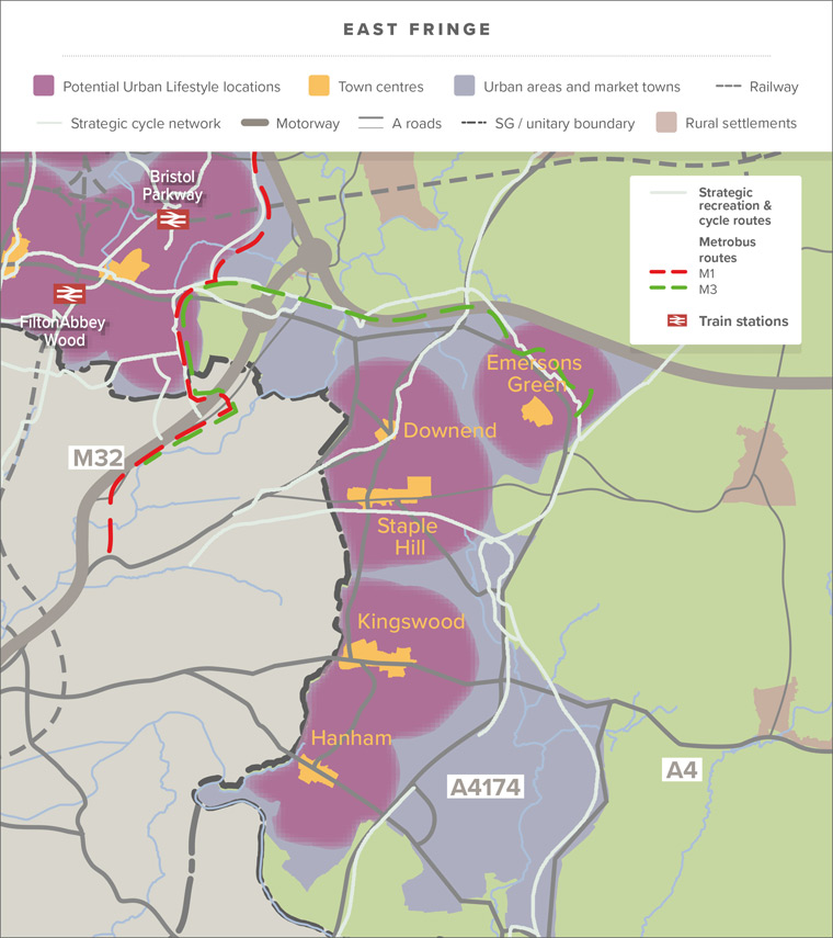
Communities of the Bristol East Fringe
This is the urban area east of Bristol City, and includes the communities of Downend, Emersons Green, Staple Hill, Mangotsfield, Soundwell, Kingswood, Warmley, Cadbury Heath, Longwell Green and Hanham.
Local communities, housing, services and facilities
This area, originally consisting of historic outlying rural hamlets and farming and hunting settlements, grew significantly alongside early coal-mining and manufacturing communities from the 18th century onwards. More suburban development followed from the Victorian period to the 1990s. Development was initially focused along the main road and rail corridors out of Bristol at Kingswood, Staple Hill, Mangotsfield, Hanham and Downend, and more recently, around the ring road at Longwell Green and Emersons Green.
Students must travel to Filton or central/south Bristol to access Further Education, as there are currently no facilities in the area. There is a leisure centre in Kingswood and a leisure centre and cinema at Longwell Green. Some communities in the East Fringe experience inequalities, and are among the most deprived in the district, with reduced opportunities for good economic, physical, mental health and wellbeing available. A new strategic and holistic approach to tackling inequality in our district is being developed and is recognised in the emerging Council Plan.
The area had a very significant role in the development of early industrialisation and non-conformist religions, and there are valued historic buildings and sites associated with its past throughout the area, including Warmley Brassworks and Gardens, Whitfield Tabernacle, and a large number of other listed and locally-listed buildings. However, there are also issues with a lack of interpretation/tourist facilities, neglect, decay and redevelopment that affect these heritage assets. There are opportunities to redevelop the area as a cultural and tourist destination, building on the Avon Valley Heritage Railway and the Bath to Bristol Railway Path (which passes through the area), Kingswood Museum, and a restored Whitfield Tabernacle. There are also opportunities for further interpretation of the wider mining, manufacturing, and non-conformist legacies of the area.
Town centres and retail areas
There are five designated town centres, with traditional high streets at Downend, Staple Hill, Kingswood and Hanham, as well as a more modern town centre at Emersons Green. These are well-placed to serve their local communities, as well as residents of the rural areas to the east. However, these town centres and their high streets are suffering because of changing shopping habits and the gradual loss of their historic employment uses. Regeneration and investment in some of these town centres is required, to promote a wider range of uses that complement traditional retailing, offer new local-employment opportunities, and improve the quality of the public realm. It is also needed to create more resilient town centres that are better able to provide for their communities. Longwell Green Shopping and Retail Park also provides a large range of supermarket, clothing and DIY stores, with a relatively wide customer base, but in a predominantly car-based environment.
Transport and accessibility
Transport infrastructure is predominantly focused on the A432, B4465, A420 and A431 main roads, which run eastward from central Bristol. The A4174 dual carriageway marks the boundary for most of the East Fringe, with a triangle of development at Lyde Green and the Science Park, as well as the communities in the south east that jut out beyond the ring road into the open countryside and Green Belt.
The Bristol to Bath railway path provides excellent walking, cycling, and green-infrastructure connectivity to Bath and Bristol city centres, and runs through Staple Hill, Mangotsfield, Siston, Warmley and Oldland Common. It also connects to rural communities, and the countryside, from Bitton. The ring-road cycle path runs north to south, and provides connections to the Bristol to Bath Science Park, from there onwards, and west to the Bristol North Fringe. However, links from the more urban areas of the East Fringe towards the ring-road cycle path are often of a poor quality and fragmented. There is a good network of public rights of way that provide potential for more pedestrian accessibility, when compared to the North Fringe.
There are no railways or stations in the East Fringe (other than the Avon Valley Railway Heritage Line). Metrobus access is limited to the connections from Emersons Green and the Bristol and Bath Science Park, to the North Fringe and Bristol city centre. However, there are regular and direct services bus connections to the city centre from Downend and Staple Hill, which also connect out to Yate. The East Fringe is also generally well-connected to the North Fringe and Bath by public transport, but this requires a relatively long journey-time. Congestion is a problem and causes significant issues with air quality at Staple Hill and Kingswood-Warmley, that contain designated Air Quality Action Zones. Congestion also leads to long journey-times to access facilities and employment in central Bristol and the North Fringe. A new mass rapid transport route from the East Fringe to Bristol city centre is a long-term aspiration.
Environment and green spaces
There are a range of parks and green spaces in the area, including formal parks at Kingswood Park and Page Park in Staple Hill. Page Park has recently benefited from significant investment, and this has considerably increased its value to the local community. There are also a number of smaller, local parks and informal green spaces throughout the area which would benefit from better connectivity and further investment, to meet the needs of local communities, and provide more opportunities for wildlife. There are registered commons within the East Fringe urban area in and around Siston and Warmley, and nearby countryside, which have significant ecological and recreational value. The adjoining countryside is important in terms of its landscape value, the views from the urban area, and for recreation and ecological networks, including Warmley Forest Park, as well as valued areas at Hanham Hills and along the river Avon. There is an opportunity to provide better green infrastructure connectivity from within the urban area and out to the surrounding countryside.
Employment and commuting
The East Fringe area has suffered a steady loss of its traditional manufacturing employment-base and a loss of employment land to other uses. This has contributed to higher levels of unemployment and inequality than in other parts of the district. There are twice as many residents as jobs in the East Fringe (a job to worker ratio of 0.4) and this has resulted in large commuter flows out of the area. Public transport access to areas of employment in Severnside and the North Fringe is poor. The main new-employment development in recent years has been the Bristol & Bath Science Park which has successfully attracted investment, and provided new opportunities for high-tech businesses, but serves a regional employment-base.
There remains demand for traditional employment premises in the East Fringe, as these uses are displaced from higher-value land in Bath and Bristol. However, the supply of this type of land is limited, and continues to be lost to residential uses. There is a need to protect and enhance local job opportunities, provide employment land, and improve access to major employment locations in the centre of Bristol and the North Fringe, while simultaneously investigating the role that the town centres and high streets can play in providing land for new business investment, beyond traditional shops and retail.
The challenge for the future of the East Fringe
An Urban Lifestyles’ approach could help with some of the local issues identified above, by providing new investment, more, and a greater variety of, homes and new local business. This approach could also help to regenerate town centres and high streets with a greater range of uses and facilities for local people, with well-designed buildings, public areas, open spaces and landscaping. It will also ensure that when key sites and redevelopment opportunities are available, the best use of available land is achieved.
The key role for the new Local Plan is to reduce inequalities, attract economic investment and improve the attractiveness of the area as a place to live and work, through:
- attracting investment and regeneration in the traditional high streets, focusing on improving the public realm, improving accessibility by walking and cycling, tackling congestion and air-quality issues, and widening the range of services and facilities to provide resilience in the difficult retail environment
- through the Urban Lifestyles’ approach, promote well-designed, new development that optimises density, and provides for new homes and businesses in the most accessible locations
- improving local access to Further Education and training
- creating as a lasting legacy, a network of green routes that provide benefits to health, wellbeing and recreation, nature-recovery and water-management and quality, by enhancing access to, and the quality of, open spaces and parks, and increases connections and views to key recreational, ecological and landscape features in the adjoining countryside
- addressing the lack of local employment and the loss of employment land, by protecting valuable employment sites, identifying land for a range of employment uses, including promoting opportunities for modern working in mixed-use developments in accessible locations
- addressing poor accessibility from some areas of the East Fringe to employment opportunities, because of longer public transport journey times from some areas, to the North Fringe, Severnside and Bristol city centre
- improving the cultural tourism and leisure opportunities, including the conservation of key heritage assets at the Whitfield Tabernacle and Warmley Brassworks and Gardens.
East Fringe Urban Lifestyles areas
The locations for Urban Lifestyles’ investigation in the East Fringe are focused in and around the designated town centres that have a range of existing services and facilities. Some have good connectivity to the strategic cycle network and public transport connections to other areas in the district, and the city centres of Bristol and Bath. In addition to the town centres themselves, there are sites near to the town centres that may also offer potential for Urban Lifestyles’ developments and approaches. Potential opportunities may become available for more intensive use of land on retail and employment areas at Longwell Green Retail Park, and Bristol and Bath Science Park. Both of which are within walking distance of town centres and well linked for walking and cycling to surrounding communities, services and facilities.
Kingswood
Kingswood has a rich history and is notably considered as the birthplace of non-conformist religion, as well as having a rich and diverse industrial tradition. The High Street straddles the A420, borders the City of Bristol, and is surrounded by residential and employment areas.
Kingswood Town Centre suffers from traffic congestion and poor air quality. Public transport serves the area, although congested routes lead to longer journey times, and passenger facilities need to be improved. However, the area has one of the highest levels of key services and facilities nearby, for walking and cycling access, but does suffer from a lack of major employers (SGC Data & Access Profiles).
Part of the town centre is characterised by a core of historic commercial and religious buildings. Although many require maintenance or restoration, they provide a strong identity for the town. By contrast, more recent developments present a less attractive and tired appearance, including the well-used Kings Chase Shopping Centre and the now vacant Store 21, both constructed in the mid-1970s. As with similar town centres, Kingswood’s retailers are suffering as a result of national trends in shopping habits, and increased competition from out-of-centre retail facilities, with vacancy rates increasing. There is a risk that, without change, intervention and regeneration, the shopping and town centre environment will go into significant decline.
Kingswood Park lies to the east of the shopping area. It is well-loved locally, and bounded by a range of community buildings and other facilities, including the former council offices, which retain a number of civic functions, alongside new library and café facilities.
Kingswood Masterplan / Love our High Streets project
To promote the regeneration of Kingswood High Street, establish a new positive identity for the High Street, and address issues of inequality while facilitating an Urban Lifestyles’ approach, the Council and the West of England Combined Authority have invested £3 million in the ‘Love our High Street’ project. Part of this funding will be used to develop a wider masterplan that directs future investment and establishes many of the qualities that an Urban Lifestyles’ approach offers, so that we can create a town centre that is more sustainable, liveable and resilient.
The master-plan work has established a number of specific objectives and areas for focused investigation, in addition to the broad Urban Lifestyles’ aims. These include:
- Strengthening the cultural and historic heart of the town centre around a new pedestrianised space, within Regent Street, and with direct links to the restored and repurposed Tabernacle
- Improving the retail and business offer, in and around the Kings Chase Shopping Centre, with enhanced public transport facilities, and the addition of a greater mix of uses and appropriate leisure and residential developments
- Increasing opportunities for Urban Lifestyles’ developments by optimising densities of residential and suitable business uses on underused industrial land to the south of Cecil Road
- Enhancing and connecting local green spaces, like Kingswood Park, Southey Park and Magpie Bottom
Kingswood has also been successful in progressing to the Full Business Case submission phase of the Government’s Future High Streets Fund. South Gloucestershire Council submitted a business case worth around £20m in July 2020. Further detail on the emerging approach to change and redevelopment in Kingswood, including the proposals set out above, can be viewed here. Engagement and consultation on these approaches and ideas is taking place through the masterplan process and will inform the future proposals we present in our new Local Plan for the Kingswood Area including, individual sites and policy approaches.
Staple Hill Town Centre
Staple Hill has a designated town centre with a traditional high street, and includes a mixture of independent shops, small chains and national food stores. It has attractive, historic buildings, as well as some more recent buildings, some of which are of poor quality. In addition to supermarkets and retail facilities, there are a range of key services and facilities, including a library, and two Primary Schools in Staple Hill.
Although there is no GP surgery, there are three in Downend (SGC Data & Access Profiles). There are a number of public transport links that connect the area to Bristol, Yate, Bath, Cribbs Causeway and Bristol Parkway. Staple Hill and its town centre have the highest level of connectivity and proximity of all of the main town centres, in the East Fringe, to the Bristol and Bath Cycle Path. However, congestion issues on the high street cause significant issues with air quality in and around the town centre, and walking and cycling links around the town centre to the cycle path could be enhanced. There are also inequality and health issues in some of the communities near to the town centre.
The area benefits from access to the Bristol and Bath Railway Path and includes Page Park, a highly-regarded, award-winning, open space. Beyond Page Park, the town centre and high street would benefit from investment in the public realm, an increase in street trees, and the provision of improved, green-infrastructure connectivity to nearby parks and commons, and the open countryside. Although, within the heavily-developed area of the East Fringe, there are incidental, but key, views and vistas to the rural countryside, which include hillsides and ridges that provide visual connectivity to open, green areas and key ridgelines in the East Fringe.
Over the next 20 years, the areas in and around the town centre could provide opportunities for Urban Lifestyles’ approaches and developments, by the intensifying and diversifying of uses in the town centre, and enhancements to the connections to the Bristol to Bath railway path. This will include the potential to build above shops and optimise the densities of development sites made available on the high street. There may also be opportunities for under-used, commercial and employment, sites to provide mixed-use development, and provide homes and jobs.
Downend Town Centre
Downend is a compact town centre with shopping parades along the A432, and a small shopping centre. It is of a smaller scale with less services and facilities than the town centres at Staple Hill or Kingswood, but still offers a good level of services and facilities, and includes GP and dentist’s surgeries, and a community centre within walking distance. Downend has public transport connections to a range of locations, including Bristol city centre and Yate – which for its size, offers a high-frequency and range of potential destinations (SGC Data & Access Profiles). The centre and areas surrounding, could be suitable for an Urban Lifestyles’ approach, subject to opportunities and sites becoming available. The process of optimising development sites would need to consider, and respond to, the existing character of the area, and protect the amenity of existing residents. This type of approach is likely to come through ongoing development in the future, and would need to be assessed against new Local Plan policies.
Emersons Green Town Centre
Emersons Green Town Centre was developed in the mid-1990s. The main car park, range of supermarkets and retail stores, follow a typical format for an out-of-town retail park, with large, single-storey unit stores on two sides of a very large, open, car park. This contrasts with the retail and community uses provided in Emersons Way, which have more in common with a traditional high street/shopping parade.
Public transport connections from Emersons Green Town Centre are reasonable, and the area has walking, cycling and public transport access to the enterprise zone at the Bristol & Bath Science Park (SGC Data & Access Profiles). Although this is a relatively newly-built town centre, there could be potential to optimise density and introduce a wider range of uses as sites and buildings are redeveloped in the future.
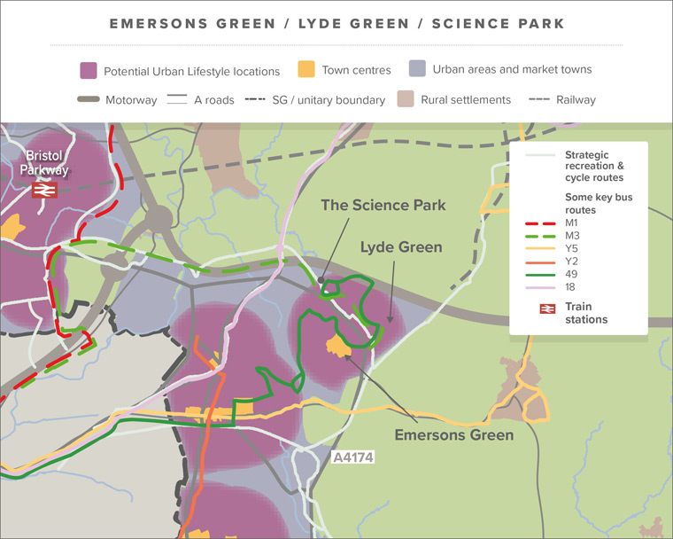
Lyde Green and Bristol & Bath Science Park
This area includes the large-scale residential development of Lyde Green, which while offering community and education infrastructure, may offer limited opportunities for Urban Lifestyles’ sites as part of the new Local Plan. The science park forms the eastern end of the proposed TEC ARC, and is spatially separate from Emersons Green Town Centre, and physically cut-off by the barrier of the A4174 — although pedestrian connections do exist, albeit limited in number. This is an enterprise area with a number of significant employers. Although there is limited land available, any commercial development sites that emerge will be expected to make efficient use of land, take advantage of the Metrobus connection, and make the best use of the pedestrian and cycling links to Emersons Green Town Centre and Lyde Green.
Hanham
Hanham town centre, is well placed to serve the surrounding suburban residential areas. It has a linear high street, originally of late-Victorian character, and a range of more recent additions and developments in the surrounding area. The high street suffers from a high level of traffic flow, and the traditional vibrancy of the centre has suffered from changing shopping habits and competition from the Longwell Green Retail Park. However, the high street contains a mixture of small independent and national retailers, and opportunities for food shopping with supermarkets nearby. A GP surgery, a number of pharmacies, and a community centre are also close to the town centre, for access by walking and cycling. Hanham has a moderate level of access to transport links and facilities (SGC Data & Access Profiles), with connections to Bristol, Longwell Green and Keynsham.
Beyond the town centre the area has key views and vistas south and east, into open countryside, and includes landscapes and hillsides at Hanham Hills and along the River Avon valley corridor that make a significant contribution to the character and form of the East Fringe.
Over the next 20 years, opportunities for Urban Lifestyles’ approach and developments, through intensification and diversification of uses in the town centre may become available. This will include optimising the density of development sites that are made available on the high street. Within walking distance of the town centre, the former Kleeneze industrial site is considered to offer potential for an Urban Lifestyles’ mixed-use development.
Longwell Green Retail Park
Longwell Green, on the south-eastern edge of the urban area, includes an out-of-centre retail area. This retail area was planned in the 1980s and includes large-format stores that sell DIY and household goods. There are also a number of smaller, and mainly, clothing stores. The area has public transport links to Bristol, Bath and Keynsham, however, links to the rest of the district are poor. Longwell Green benefits from walking and cycling access to a community centre, a wide range of supermarkets, three pharmacies and three primary schools, and near a cinema and leisure centre. However, with the exception of employment in the Retail Park and supermarkets, there are no other major employers, and no GP surgeries nearby (SGC Data & Access Profiles).
The entire area is functional in character and dominated by large-format stores and surface car-parking. Current opportunities for an Urban Lifestyles’ approach are relatively limited. However, the area has public transport links to Bath, Bristol and communities in the East Fringe, and there may be opportunities, over the next 20 years, for more efficient uses of land, that introduce a greater range of uses, including new homes with a density appropriate to the location.
Yate
Yate is a successful market town with a population of approximately 30,900 (derived from the 2018 mid-year population estimate, ONS). It is located five miles from the urban edge of Bristol, and is separated from it by the Green Belt. It adjoins and, in many ways, complements the historic market town of Chipping Sodbury to the east.

Local communities, housing, services and facilities
Yate was first planned and developed in the late 1960s and based on the foundations of an older community. Growth has continued to the present day and includes a major new neighbourhood in the north which is still being completed. Housing is mainly low-density and suburban in character.
Many local students have to travel to Filton and Bristol to access Further Education, as there are limited facilities in and around Yate. However, access to South Bristol & Stroud College campuses via Filton Abbey Wood station is available by train from Yate, with the service set to be increased to a 30-minute service.
Local health facilities are available with a minor injuries unit, as well as a GP surgery in the town centre. Yate also has a leisure centre, outdoor sports-centre, cinema and the Yate Heritage Centre, as well as a number of smaller community buildings, including dedicated youth facilities, mainly located in the town centre and surrounding area.
Town centres and retail areas
Yate town centre includes the main shopping centre and extends along Station Road as far as Yate Station. The shopping centre, built in the late 1960s, provides a very good range of shops and services, as well as community buildings and health facilities. It is well located to provide for its local community, and also serves the surrounding rural areas and Chipping Sodbury.
Station Road is a continuation of the town centre and links it to Yate station. It is a mixed area, with residential, employment, retail areas and community uses, side-by-side, much of it at low-density.
Transport and accessibility
Yate station provides rail access to the North Fringe, Bristol and Gloucester. There is currently an hourly service, but improvements to services are planned. Access from Station Road is currently poor, particularly for pedestrians and cyclists, and the station environment for passengers requires considerable improvement. Yate Town Centre is a hub for local bus networks and services to further destinations, including the North Fringe, Bristol city centre and Wootton.
Yate has a good network of cycle and walking routes, but access for pedestrians and cyclists to the shopping centre and along Station Road, is not as good as it should be. This has resulted in a large majority of people accessing the centre by car, despite the relatively short distances from residential areas. There is potential to significantly increase access by walking and cycling as a mode of transport within urban Yate.
Environment and green spaces
Yate has highly-valued green spaces and routes which could be enhanced and better-connected, to provide benefits for wildlife, health and wellbeing, and climate change mitigation and adaption. By investing in green infrastructure, we have a real opportunity to strengthen the connections between people and their local environment:
- the River Frome runs through the town from east to west — there are opportunities to reconcile ecological, water management and recreation issues along this corridor, with the aim of enhancing all three aspects
- the Common is an extensive area of common land that has important grassland habitat and recreational value. In the future, these two aspects will need to be managed and reconciled, as pressure increases from a growing local population
- Yate is surrounded by attractive countryside and includes areas of high landscape value in the Cotswold AONB, nearby to the east and including areas in the Green Belt — this provides recreational opportunities for residents
- there are extensive green walking and cycling routes in the town and local parks — improving this GI connectivity in Yate, and providing links to the surrounding countryside will provide enhanced benefits for nature recovery, as well as health and well-being benefits
Employment and commuting
Yate has relatively good local employment opportunities, particularly in manufacturing and distribution, with the main safeguarded employment areas to the west and north edges of the town. However, there are more resident workers than local jobs in Yate (ratio of jobs to workers is 0.7).
To meet the needs of businesses, and provide local jobs for a growing population, the Plan must make provision for existing and new businesses by:
- the safeguarding and redevelopment of existing employment land
- introducing more diversity to the town centre
- potentially, providing new employment-land alongside any new housing developments, or by replacing any employment land lost because of the redevelopment of the station area
The challenge for the future of Yate
The key role for our new Local Plan is to reduce inequalities, attract investment and improve the attractiveness and connectivity of the area as a place to live and work by:
- realising the potential of the shopping centre ‘island’ by master-planning and cooperation between landowners, including the public sector — this would aim to optimise the use of available land, and provide for a broader range of services, retail and leisure opportunities, as well as improved public spaces, to increase footfall, dwell time, hours of activity and provide new forms of residential and employment spaces.
- planning for, and providing, a much-improved walking and cycling environment, to and within the town centre, to achieve a shift away from car journeys from residential areas and achieve the associated benefits for health and well-being and carbon reduction.
- delivering improvements to Yate Station, to realise the potential for rail travel in Yate.
- planning for long-term, higher density, mixed-use development, around the station and parts of the adjoining industrial estates — to optimise density of new development between the station and shopping centre while respecting the character and amenity of existing uses, and providing new opportunities to live and work in this highly-accessible location
- providing for existing and new businesses, by protecting appropriate land for a range of employment uses, including new types of employment uses and businesses, and identifying land suitable for mixed use Urban Lifestyles’ developments.
- Enhancing and connecting the green spaces in Yate, including the Frome corridor and the Common, and connecting them to the town centre and wider countryside, and creating a lasting legacy of green and blue network routes that provide benefits for health and wellbeing, and recreation, as well as nature-recovery and water-management and quality.
Areas of Yate where an Urban Lifestyles’ approach might be appropriate
Yate Shopping Centre
Built in late 1960s, the shopping centre is 2-3-storeys high, with retail and public services that face inwards onto pedestrian walkways, and have limited residential accommodation above the shops. Due to national retailing trends and changes in consumer habits, the centre has suffered from a loss of footfall in recent years, which has resulted in vacancies, particularly at the edge of the centre.
Buildings and public spaces require investment, and there is a need to broaden their range of activities and uses during the day and evening, to maintain the vitality of the centre and significantly improve pedestrian access to the adjoining residential areas.
There are a number of public buildings, poorly-designed areas and ineffective uses of land on the ‘island’ that are low-density and offer potential for reorganisation and redevelopment to optimise densities and increase the mix of uses. This includes homes and employment adjacent to the shopping centre. There is also potential in the main shopping areas for an increase in densities, and a greater mix of uses on upper floors.
The shopping centre is owned and managed by a single landowner, and there are also a variety of public-sector landowners in the shopping-island area. This provides us with opportunities for a coordinated approach to regeneration and redevelopment.
Station Road
Station Road formed part of the older core of Yate and runs, from the station in the west, to the shopping centre. It is of mixed character with offices, industrial, retail, residential and community uses. The buildings are mostly of two-storeys, with some elements of the heritage and character of the older settlement remaining. The route suffers from congestion and is an uninviting environment for walking and cycling. There is potential to increase density, but this presents problems with achieving design objectives and vision, and issues around respecting the amenity of neighbouring uses. A comprehensive strategy is needed to achieve a shift towards more walking and cycling along this route, including the potential enhancement for non-car-based users, and the provision of design guidance.
The variety of land uses and landowners mean
that redevelopment will happen in a piecemeal way, and over time. There is a risk that opportunities to achieve the community’s vision for this area will be missed, unless there is a more coordinated approach to development. This includes more guidance on future uses, and design and character relationships between neighbouring uses. This would support the role of Station Road as a continuation of the town centre, linking the shopping centre and station, and achieve maximum benefit from redevelopment.
Yate Station and surrounds
There is currently an hourly train service from Yate station to the North Fringe and Bristol city centre and Gloucester, with planned, enhanced services to two trains per hour. This will help it to become a more attractive option than driving, to access the North Fringe and Bristol city centre.
The station is currently surrounded by low-density employment uses. Optimising densities and the mix of uses in walking distance, and along Station Road and its surrounding industrial estates, could help realise this highly-accessible area’s potential, with longer-term opportunities for higher-density, mixed-use development on some of the surrounding industrial estates. A Yate master plan is currently being prepared, and will include the investigation of potential approaches to improvements to the station and make efficient use of the land on the industrial estates around the station.
Yate Town Improvement Masterplan
The Council is working with local public and private sector partners on a master plan for Yate, with funding provided by the West of England Combined Authority. The master plan will be an important document that shapes the future of Yate by setting out the long-term, detailed vision and objectives for the town. Building on the character of the town, the master plan seeks to unlock heritage, social, community and economic opportunities, and support investment in Yate in the future.
Thornbury
Thornbury is an historic, planned, market town, with a population of 12,200 (derived from 2018 mid-year population estimate, ONS) approximately 10 miles north of Bristol. Thornbury has no rail access, but has regular bus connections south to Bristol and north into Gloucestershire, as well as a network of local services to surrounding villages. It is close to Junctions on the M4 and M5 and to the A38.
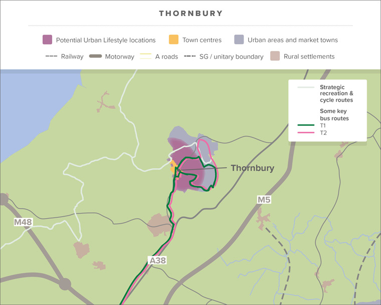
Thornbury includes a range of key services and facilities, focused in the town centre, that serve residents, and can act as a service centre for the surrounding rural areas and villages. It has a very mixed town centre which retains its historic character – the centre is a designated conservation area. It has open areas of car parking and is surrounded by open countryside, including Green Belt protection to the south and west, and suburban development to the east. There are a high number of independent shops, often in smaller historic premises, on the High Street, as well as some national retailers, and two supermarkets.
Thornbury has a wide range of community facilities, including the Armstrong Hall complex, Thornbury Museum, Turnberries, and the Chantry community centres and a leisure centre. The Mundy playing fields provide a valued recreation resource near to the town centre. The town is surrounded by, and well-connected to, the countryside. Thornbury Castle is a Tudor Grade 1 Listed building, which is a destination in its own right, and adds to the historic and cultural offering of the town.
The Core Strategy planned for 500 new homes in Thornbury, but speculative development has increased this planned growth. This development has been to the north and east of the town and is increasingly further from the town centre. This growth in housing, together with the loss of some safeguarded employment land, may have affected the balance between jobs and resident workers in Thornbury, which was 1:1 at the time of the last census in 2011. Car ownership and commuting levels are high.
A draft Thornbury Neighbourhood Plan 2019-36 has been prepared by the community, and is based on extensive consultation and evidence. The latest draft of the Thornbury Neighbourhood Plan can be viewed here. The draft plan went through a consultation between 29 February and 25 April 2020, and the group are currently considering the comments received and making updates to the draft version. The neighbourhood plan sets out the key issues, vision, objectives and policies, to guide growth in Thornbury until 2036. Once adopted, the neighbourhood plan will become part of the development plan, and be used to guide planning decisions, together with our new Local Plan, SDS and national planning guidance (NPPF).
The challenge for the future of Thornbury
There are a range and good number of services and facilities centred on the historic high street area. There is potential to optimise the density of future development that takes place in and around Thornbury’s town centre, while taking into account the issues, vision and policies in the draft neighbourhood plan, as well as in national and local policies.
Key issues for future development in Thornbury are:
- protecting and respecting the heritage and character of the historic town and its setting, in particular the conservation area and listed buildings
- supporting the regeneration and economic health of the town centre
- providing new employment opportunities to help provide a better balance between local residents and jobs
- supporting the provision of key services and facilities
- as one of our two market towns, exploring the potential of Thornbury to meet a share of our overall housing needs
- providing new housing for young people and downsizers, that is affordable for local people
- promoting walking and cycling links in the town, and to nearby open countryside
- Protecting key views into, and out of Thornbury, as well as landscape features and enhanced ecological networks
- ensuring that any new development does not exacerbate flood-risk issues in the lower-lying land and communities to the west of town.
Questions and comments
To answer these questions visit our online consultation page at www.southglos.gov.uk/localplan2020-feedback to complete or download our questionnaire.
Read the next chapter – Creating sustainable rural villages and settlements.
Go back to the Local Plan 2020 – Phase 1 Issues and Approaches document landing page.