Page contents
- Existing issues in our rural communities
- Local Plan 2020 – this consultation
- Where should we investigate for growth in our rural areas?
- Investigating ‘appropriate’ small and medium-scale growth
- Key sustainability issues
- Key planning designations and considerations
- Summary
- What happens next?
- Appendix 1: Summary of Green Belt options
- Questions and comments
Local Plan 2020 Phase 1 consultation
As we prepare our new Local Plan 2020, we want to have a discussion with our communities about how we might investigate and approach planning for an appropriate level of small and medium-scale growth in rural villages and settlements.
This work will help us focus on maximising the benefits of development, and enhancing the sustainability of our rural communities. As part of this, we want to understand, protect and enhance the natural and heritage assets that make such a valuable contribution to the unique character of our villages and settlements.
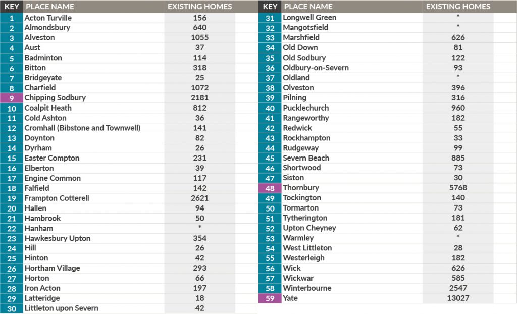
Through the Core Strategy and previous Local Plans, the majority of the planned growth of homes, jobs and infrastructure has been focused on the communities of the Bristol North and East Fringes and the market towns of Yate, Chipping Sodbury and Thornbury. Beyond these areas, a comparatively small amount of development has come forward in our rural villages and settlements through the planning application process, and it has been mostly limited to infill within existing settlement boundaries.
A disadvantage of this approach is that the historic pattern of incremental investment in the sustainability of our rural communities that comes from growth, has been disrupted. Because of this, progressively, the benefits of well-planned growth haven’t been felt in our rural villages and settlements. Development can provide local market and Affordable Housing, new employment opportunities, improved infrastructure, including walking, cycling and public transport upgrades and it can also support local services and facilities.
In more recent years some of our rural villages and settlements have also been the focus of ‘speculative’ development proposals, which are usually promoted through planning applications. This growth and change has not been arrived at through a plan-led strategy, and often, without a comprehensive understanding of the needs of, or support from, the communities in which they are proposed.
Our rural areas include many natural assets, like sites designated for their ecological value, the Cotswolds Area of Outstanding Natural Beauty – designated for its distinctive landscape character and natural beauty, the Severn Estuary, protected by a range of nature conservation designations due its important habitats and species, and green infrastructure – which is important to create a sense of place that connects communities to the countryside and provides space for wildlife to thrive in. Our rural areas are also home to a wide range of heritage assets, including conservation areas, listed buildings and sites of archaeological value. There are also landscape features like valleys, hillsides and escarpments, all of which help to create valuable, historic landscapes and distinctive places. A large area of rural South Gloucestershire is also designated as Green Belt.
As we consider our approach to planning for our rural areas, and the villages and settlements in them, we need to balance all of these issues and considerations, and make choices about where new homes, jobs and facilities should go, so that our rural communities can thrive.
Existing issues in our rural communities
In Section 3 of this document we discuss the issues that face all of South Gloucestershire, that need to be considered as we plan for the future. We think that some of these issues are of particular relevance to our rural areas and they are explored below.
Meeting the challenge of climate change is of central importance to the way we must plan for growth. It is an objective of national planning policy, and its importance locally has been further emphasised through the Council’s declaration of a Climate Emergency in July 2019. Our new Local Plan has an important part to play in the Council’s response to this issue, by promoting development which reduces the impacts of climate change. When considering rural growth, we think this includes:
- focusing rural growth in locations that aren’t completely dependent on private car use to access key services and facilities
- maximising opportunities for development in locations that have good walking, cycling or public transport and digital connections to access key services and facilities
- exploring opportunities that contribute to achieving key plan priorities around the creation of nature recovery and green infrastructure networks
- providing for biodiversity offsetting and for renewable energy generation.
Issue 1: Climate change mitigation; Issue 2: Climate change adaption and resilience; Issue 41: Decarbonising transport; Issue 43: Access to key services and facilities in our rural areas
The population of South Gloucestershire is projected to continue to grow, as is the number and proportion of older people. Many of our rural communities have a relatively older population than the local or national average. Our new Local Plan will need to think about how our rural communities can play a part in supporting population growth and change, and in doing so increase their social sustainability.
We’ll need to consider if more purpose built, specialist homes and a wider choice of accommodation for older people is needed. We’ll also need to make sure that new homes are adaptable and accessible, and provide opportunities for people to live independently and stay in their communities as they age.
Issue 27: Identifying the amount of new homes to plan for; Issue 28: Homes to meet the needs of our ageing population
It is common in rural communities, that access to a choice of housing, in particular Affordable Housing, specialist housing and smaller-market housing, is an issue. This can make it difficult, particularly for younger people and families and people on lower incomes who want to remain in, or move to, our rural communities. We’ll need to look at evidence for specific sizes, types and tenures of homes in rural areas, including self-build and custom housebuilding and the potential for Community Land Trusts and other forms of delivery, to provide an affordable alternative for local communities.
Issue 29: Housing affordability; Issue 30: Planning for different groups
Over the last 30 years, planned growth has been focussed on larger sites in locations next to the existing urban area at the North and East Fringes of Bristol and the market towns of Thornbury and Yate. As a result, the benefits of growth have been directed to a limited number of places.
Additionally, over-reliance on a small number of large sites has weakened the resilience of our housing land supply, as these larger sites haven’t delivered the homes and jobs as quickly as promised, by their promoters, when the Core Strategy was developed. The impact of this has been an increase in speculative development proposals in some rural communities. These are put forward and justified, in part, by the need to make up for the shortfall in delivery on the larger sites in the short to medium term. At the same time, many of our rural communities have seen comparatively low rates of growth, which has created problems with the availability, choice and affordability of homes, impacting on the mix and balance of communities and local services and facilities.
Following changes to national planning policy in 2019, we’re now required to accommodate at least 10% of new homes on sites that are no larger than one hectare in size. Through our new Local Plan we will look to increase the amount of growth brought forward from small and medium-sized sites. This will reduce the risk of reliance on speculative planning applications to bolster housing supply when delivery on large sites is unexpectedly delayed.
As part of this, we’re already investigating how greater levels of growth can be accommodated in our urban areas, and you can read about this in section 5. We think this provides an opportunity to think about growth in our rural communities and the contribution they can make in helping to meet this requirement and investigate the potential benefits growth can bring to these communities. Beyond the urban areas, we want to investigate how we can provide a range of small and medium-scale sites in our rural communities, and how we might approach that. This could support the sustainability of rural communities, meet a range of housing needs, and help them overcome their individual challenges.
Planning for some level of growth, like new homes, employment and key services and facilities, in appropriate rural villages and settlements, can play an important role in making sure that the long term vitality, vibrancy and overall sustainability of our rural communities is maintained by:
- increasing opportunities for home ownership and renting for younger people, families and an increasingly ageing population that want to stay in, or move back to, their communities
- increasing access to education and employment opportunities in easy reach of where people live
- supporting the long-term sustainability and success of education facilities, particularly those rural primary schools that have seen a decline in class sizes in recent years
- supporting existing and/or enhanced key services and facilities in rural communities, like local shops, community centres, public houses, broadband connectivity, local employment opportunities, and the viability of public transport connections to towns and urban areas.
This approach could help stimulate new sources of supply, like smaller, local builders, private individuals, community-led housing schemes or through proposals for ‘self-build’, or those who are unable or unwilling to develop larger sites. As discussed above, this might also support the local economy, by providing and safeguarding jobs in the construction industry, to support the post COVID-19 economic and social recovery.
Issue 32: Issues with housing delivery on large scale sites; Issue 33: Five year housing land supply; Issue 34: Small site requirement; Issue 25: Growth in rural villages and settlements
Local Plan 2020 – this consultation
Based on the opportunities and issues identified in this document, we want to discuss an approach that seeks to improve the long-term sustainability of our rural communities. We want to explore what we need to think about, if an appropriate level of small or medium-scale growth in our rural villages and settlements, is to form part of the new Local Plan.
Initially we think that unless there are significant constraints, sustainability, or other key issues, that every rural community should be investigated and considered. This will help decide the part these communities might be able to play in contributing to and benefitting from plan-led growth.
Our Local Plan 2020 will in future stages of consultation need to identify specific sites in individual villages and settlements, to be allocated for new homes and/or employment opportunities and, potentially other important land uses. We can’t discuss what level of growth might be appropriate in individual rural villages/ settlements at the moment, or the merits of individual sites. Before we can start do this, we need to understand the overall growth target that we’ll need to accommodate in our new Local Plan. This will be set out in the West of England Spatial Development Strategy (see section 5).
But as part of this first consultation we want to discuss how we might consider; which villages and settlements might be suitable to investigate for growth, and what level of growth might be appropriate in those villages and settlements.
By taking a ‘plan–led’ approach to potential growth and change in our rural communities, we can fully discuss the issues, supported by evidence gathered from technical work and through a programme of community engagement and public consultation.
We also want to develop a policy framework that allows for rural exception sites to come forward in response to community identified needs and community-led proposals. The new policy framework will cater for specific rural issues, including the promotion and sustenance of the rural economy, horse-related development and rural worker’s dwellings.
In preparing a new Local Plan, must also understand which sites might have the potential to be allocated. To do this, we have recently undertaken the Call for Sites 2020, to identify sites.
These sites will have to be assessed through the Housing and Economic Land Availability Assessment (HELAA).
When this work has been completed, we’ll be able to begin to look at potential options at a village and settlement level. We will present the outputs of this work through a Local Plan 2020 – Phase 2 consultation document, which we hope will be available in Autumn 2021.
What do we mean by planning for small and medium scale growth in our rural communities?
When we talk about ‘small and medium-scale growth’, we are referring to planned growth, which is appropriate and proportionate to the size and scale of existing rural communities. We want to make sure that there is a balance between the potential benefits of growth and the need to ensure we protect and enhance existing character and built, natural and community assets.
The Plan is in its early stages and we don’t have a precise number of homes, or amount of employment land, in mind for any individual village or settlement. It is important, at this stage, to stress that any small or medium-scale growth proposed through this part of the Local Plan should not be of a scale that might lead to a strategic level change for any community, or require the provision of additional strategic infrastructure.
Generally, when we talk about ‘growth’ in rural areas we mean sites that, as a minimum, can provide five homes or more. Or, opportunities that provide employment uses on sites of 0.25 hectares, or 500 square metres of floor space and more. We must allocate this growth through future stages of the Local Plan.
It is also important to note that any proposed growth should be ‘appropriate’ for the village or settlement it is located in. By this, we mean that it should be proportionate and sensitive to the village or settlement’s sustainability, and take into account any potential impacts on its character and function over the next 10, 15 and possibly 20 years. Because of this, we aren’t yet able to define a maximum number of new homes or jobs that might be considered small to medium-scale, because this will depend on the individual village or settlement, and how any new growth might play a part in supporting its sustainability. What is appropriate will differ from place to place, and could be based on a number of sustainability, planning and local considerations.
We want to discuss and explore this with you, and you can find out more below.
We are aware that, separate to any growth proposed through the Local Plan, communities may also want to consider opportunities to promote sustainable growth with a rural exception site or by preparing a neighbourhood plan. These methods may offer another way, beyond the Local Plan process, to promote growth and change, and meet needs identified by rural communities.
As well as this, opportunities to bring forward development on infill sites, or sites within settlement boundaries could come forward through the development management process.
What about large scale growth in rural communities?
Through previous plan making and ‘Call for Sites’, proposals have been submitted to us for consideration of larger-scale planned growth in, or near, our rural villages and settlements. These are typically, but not exclusively, sites that would bring about very significant change for an individual village or settlement, or require strategic levels of infrastructure to be developed.
Any sites of this type or scale submitted through the recent Call for Sites will need to be assessed, and then considered through preparing the Local Plan 2020. We understand this can be challenging for communities who might not support proposals like this, either in principle, or due to their specific impacts. It is important to note that no decisions about whether individual sites should be allocated will be made until they have been given appropriate consideration in future stages of preparing our new Local Plan and have been subject to public consultation.
In section 5 of this document, we explore and discuss the possible guiding principles we may use to investigate potential locations for large-scale growth. After this consultation, we will gather more evidence and technical information, before we present the options for villages, settlements or locations that might be investigated for larger-scale growth through our Phase 2 consultation document. We hope to release this document in Autumn 2021.
The potential to deliver larger-scale growth might be an option in some of our rural villages and settlements instead of, or in addition to, any proposals for small and medium-scale growth.
As our new Local Plan progresses, we will clearly state which rural villages and settlements will be investigated for large-scale growth, as well as those are considering for small and medium-scale growth.
Where should we investigate for growth in our rural areas?
As we begin to investigate potential and appropriate levels of growth in our rural communities, we want to consider the following locations:
- in and around all villages and settlements* with a defined settlement boundary, or, recognised collections of dwellings , and areas around the edges of market towns
- areas where sites have been identified through previous calls for sites, up to 200 metres from the edges of urban areas.
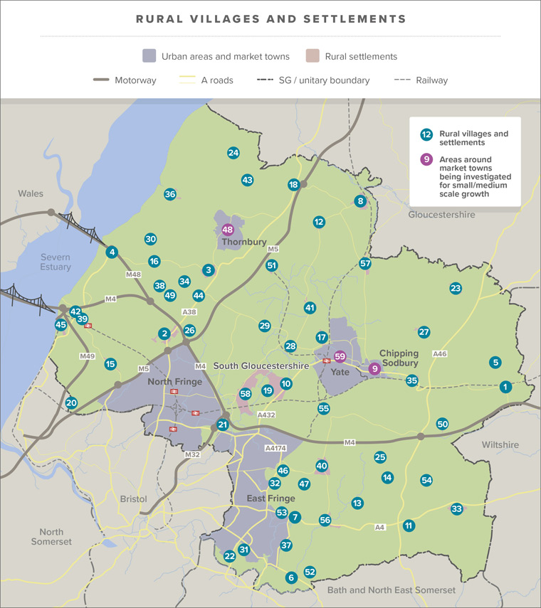
*Villages and settlements with existing settlement boundaries, defined on the Policies Map and considered for settlement boundaries or growth as part of the Policies, Sites and Places (PSP) Plan rural housing review have been included in the initial list of villages, settlement and rural places.
Are all of these locations sustainable and appropriate for investigation for planned growth?
Working with our communities we want to discuss how we investigate potentially appropriate levels of small to medium-scale growth that could be allocated in our new Local Plan.
Because of significant constraints and sustainability issues, it might not be appropriate to propose growth through the Local Plan in some of these locations. Instead, it might be appropriate for growth, to meet an identified local need for homes or jobs, to be brought forward through a neighbourhood plan or a community-led rural exception site.
As we begin to think about what level of growth might be appropriate in our villages and settlements, we want to discuss a range of key principles that could inform and aid the investigation and discussion of this topic.
Investigating ‘appropriate’ small and medium-scale growth
As detailed in section 3 of this document there are some key sustainability and planning policy issues which are important in our rural areas and will help us to determine appropriate levels of growth in individual villages and settlements.
We think the key considerations include:
- the size of existing village and settlements – relating to populations and the number of existing homes
- The level of planned and speculative growth that has been built or approved in individual communities in recent years, if applicable
We will use information relating to demographics and planning at village/ settlement level to aid our understanding of these considerations across our rural communities.
- The suitability and capacity of existing infrastructure and, any potential requirement for new utilities infrastructure – especially sewerage, water, power and gas
- Key sustainability issues – sustainable access to key services and facilities, small and rural schools, and access to superfast broadband
We explore these in this section, in more detail below.
- Key planning designations and considerations;
- Flood Risk, Areas of Outstanding Natural Beauty, Green Belt
- Impact on important ecological, heritage, local landscape assets and character.
More information on how we want to approach these issues is discussed below.
Key sustainability issues
Initially, we think sustainable travel for access to services and facilities should be a primary consideration because it relates to the guiding principles presented in section 5 of this document. This means we should make choices about what an appropriate level of growth in individual villages or settlements might be, based on the principle of minimising reliance on private car journeys, while considering:
• proximity to key services and facilities, including employment, retail, education and community, health and education facilities by walking and cycling
• the level of access to effective public transport connections, that can sustainably link rural communities to major centres and destinations where employment opportunities, retail, education and community, health and education facilities are available
• how new, or enhanced services and facilities, or new transport infrastructure, may come forward, through the Local Plan or other plans/ strategies, that could improve access to sustainable travel in rural communities.
As well as this, there are other factors that could be taken into account when we investigate potential and appropriate levels of growth in individual villages and settlements. This includes the Council’s Small and Rural Schools Strategy, and other issues related to schools in rural areas, as well as the provision of superfast broadband. We discuss these issues in more detail later in this document.
Sustainable travel for access to services and facilities
Greenhouse gas emissions from road transport make up around a fifth of UK greenhouse gas emissions, and this makes it a significant contributor to the acceleration of climate change. Addressing climate change is a longstanding priority for the Council, further emphasised by its declaration of a Climate Emergency in July 2019. For this reason, we want to make choices relating to growth that minimise the need for essential journeys, to access key services and facilities to be made by private car. This supports the emerging Local Plan priorities, in particular, those relating to pursuing a carbon neutral and resilient future in a changing climate, and achieving sustainable travel and transport.
As noted in the Issues section of this document there is variation in our rural villages and settlements, in the level of access to key services and facilities by walking and cycling, and access to effective public transport connections. For example, villages and settlements that are closer to urban areas and market towns are more likely to be able to take advantage of the full range of services and facilities available in these locations, provided safe walking and cycling access is available, or suitable public transport connections exist. In contrast, villages and settlements located further away from these service centres often have access to fewer local services and facilities, sometimes with no suitable public transport connections for access to further services and facilities. In these instances, there is usually a greater reliance on travel by private car.
We already consider opportunities to access services and facilities using sustainable means, like walking, cycling and public transport, through Policy PSP11 of our adopted Local Plan, in the Policies, Sites and Places (PSP) Plan 2017. Policy PSP11 sets out the key services and facilities that should be in walking and cycling distance. Where key services and facilities are not accessible by walking and cycling, they should be within an appropriate distance of a bus stop, served by an appropriate level of public transport services that connect to destinations that offer the remaining key services and facilities.
For the purposes of this section, an appropriate level of public transport service is considered to be:
- Individual or combined services, total journey time under 1 hour.
- At least 5 services a day during the week, 3 at weekends, to and from the destination.
- During the week; one service arriving at the destination before 9am, and one leaving after 5pm.
The table below displays the key services and facilities, and the walking and cycling distances considered to be appropriate in this policy. The routes to these facilities should also be safe for walking and cycling.
| Key Services and Facilities | Appropriate walking and cycling distances |
| Retail (comparison) shops and services and/or market towns and town centres (defined in Core Strategy Policy CS14) | 1,200 Metres |
| (Weekly) superstore or supermarket | 1,200 Metres |
| (Day-to-day) smaller food (convenience) shops | 1,200 Metres |
| Local health services | 1,200 Metres |
| Pharmacy | 800 Metres |
| Dedicated community centres (defined by South Gloucestershire Council) | 800 Metres |
| Post offices | 800 Metres |
| Public houses | 800 Metres |
| Secondary school | 3 Miles* |
| Primary school | 2 Miles |
| Major employers, designated town centres, and safeguarded employment areas (defined in Policy CS12 of the Core Strategy) | 2,000 Metres walking 5,600 Metres cycling |
*The Education Act 1996 set the maximum statutory walking distance as 3 miles for secondary schools 3 miles and 2 miles for primary schools – please see the South Gloucestershire 2018 Sustainable Access Methodology for further explanation (paragraphs 7.6 & 9.9).
Data and Access Profiles (DAPs) have been produced for each of our villages and settlements. Each profile shows the current level of walking and cycling access to these key services and facilities. It also provides an understanding of the current level of suitable public transport access to major centres and destinations for services and facilities not accessible in the village or settlement. More information about this evidence can be found in the DAPs and supporting Data and Access Methodology can be viewed online here.
Please note that the evidence presented in the DAPs represents a point in time. If any of the information included is out of date, we would welcome your feedback, particularly as we are aware that changes as a result of Covid-19 may have had an impact on specific elements of this evidence.
Because of the emerging plan priorities discussed above, and our proposed focus on minimising reliance on private car journeys, we think that the Data and Access Profiles provide us with information that will help us to investigate and discuss what might be proportionate and sustainable growth in individual villages and settlements. They provide a snapshot of the current level of access to services and facilities, including those that are not currently available or cannot be accessed by sustainable means.
When considering and investigating the level of growth that might be appropriate in individual villages and settlements, it is important to understand how any growth might support existing services and facilities, or provide new services and facilities, and in doing so help to create more sustainable communities. It is also be important to understand and recognise that new transport infrastructure or development may also lead to an enhancement of the level of sustainable access to key services and facilities in specific villages and settlements.
In some of our rural villages and settlements, where there is a lack of walking, cycling and public transport connections and where small or medium-scale growth is unlikely to improve provision of key services and facilities or transport infrastructure, it might not be appropriate, for sustainability reasons, to consider growth through our new Local Plan. In instances where those communities have identified a local need for new homes or jobs, provision exists for these to be considered and brought forward instead through a neighbourhood plan, or a rural exception site.
Sustainability of small and rural schools
Small and rural schools have an important role to play in providing local educational provision in our rural communities, and ensuring that every child and young person can access high-quality, local, school provision.
The Department for Education (DfE) refers to small schools as having fewer than 210 pupils on roll. In the case of rural schools, the DfE has for many years has been particularly concerned about schools serving rural communities and under the Designation of Rural Primary Schools [England] Order 2019, designates 16 maintained primary schools as ‘rural’ in South Gloucestershire.
We are aware of the very specific pressures faced by small and rural schools as a result of relatively low numbers of children on roll. This has implications for the structure and organisation of schools, and in some cases can threaten the long-term financial viability of small and rural schools. The Small and Rural Schools Strategy sets out the Council’s approach, and commitment, to ensuring their sustainability by developing collaborative models of leadership, and using a joined-up approach to planning and housing delivery, that allows small and rural schools and communities to continue to thrive.
The Council has an obligation to provide free transport to educational facilities where there is no safe or appropriate walking routes, within a minimum distance from a child’s home. Although there are a limited number of secondary schools in South Gloucestershire, and some degree of travel is likely to be necessary, there are a significant number of rural primary schools of various sizes in rural villages. Providing free school transport, to homes beyond walking distance of existing and planned education facilities, has created a considerable and long-term financial cost for the Council. Where longer distance travel is needed to access education facilities, it can encourage more private car journeys, and this conflicts with our new Local Plan’s emerging priorities regarding sustainable travel and climate change. By making good choices about possible locations for development, and appropriate levels of growth, on the basis of proximity for access by walking, the long-term cost of free school transport to rural schools could be reduced or minimised. This would benefit the Council and rural communities.
Access to superfast broadband
In recognition of the important role that access to superfast broadband increasingly plays in meeting people’s shopping, employment and social interaction needs, we think this should be considered when we investigate what might be and appropriate level of growth in individual villages and settlements. The importance of access to superfast broadband has been further underlined during the Covid-19 pandemic, where opportunities for non-essential face-to-face interaction have been limited by restrictions on movement to limit the spread of the virus. As part of this, we have seen wide-ranging changes to working practices, including the need for a large proportion of the population to work from home which, for many, requires a reliable internet connection.
Notwithstanding this, the Covid-19 pandemic has also served to underline the importance of our ability to gain physical access, rather than virtual access, to some key services and facilities, including employment for many key and frontline workers, and retail, health and community facilities.
With this in mind, we don’t think that access to superfast broadband, alone, replaces the need for physical access to services and facilities, as doing so may result in growth in locations where access to services and facilities can’t be achieved by sustainable means like walking, cycling or public transport.
Like the other considerations discussed above, there is significant variation in access to superfast broadband, both between villages and settlements, and also within those villages and settlements. We think an understanding of this could help to inform decisions about what level of growth might be appropriate, and might possibly support the consideration of specific sites, in the next stage of preparing the Local Plan 2020.
Key planning designations and considerations
There are several planning considerations that arise as a result of national planning policy, and we will need to take them into account. These are:
- flood risk and climate change – making choices based on the need to take a sequential, risk-based approach to flood risk when considering where development should be located. At the same time, we want to investigate and gain an understanding of the needs and aspirations of communities located in areas at risk of flooding.
- the Cotswolds Area of Outstanding Natural Beauty – making choices based on the need to maintain and enhance the natural and cultural qualities of the Cotswolds. Through doing so, we will recognise the role the environment plays in supporting jobs, businesses and a vibrant local rural economy, as well as the wide range of recreational and health and well-being benefits the AONB provides to the communities within the Cotswolds and across the wider area.
- Green Belt – making choices based on the need to maintain the purposes of the Green Belt (as set out in national policy), while recognising that a large number of our rural villages and settlements are located in the Green Belt, understanding that some rural villages in the Green Belt are near key services, facilities and public transport, and may not be covered by other planning designations or issues.
- other national and local planning designations that relate to our environment, heritage and built assets, that will need to be considered in the context of individual villages and settlements.
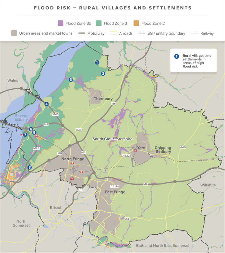
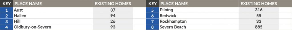
Flood Risk
The Issues section of this document discusses areas in South Gloucestershire that include areas identified as being within Flood Zone 3 (highest risk) and Flood Zone 2. They are primarily focused in the area adjacent to the Severn Estuary (Section 3 – Issue 11). Climate change is likely to have an impact on flood risk, both, increasing the extent of the area at higher risk, as well as the frequency of flood events. One of our new Local Plan’s priorities is to make sure that when delivering sustainable growth, we consider the impacts of a changing climate and plan accordingly to deal with it.
National policy requires us to take a ‘sequential approach’, which means only investigating growth in areas of the highest flood risk if our growth needs can’t be accommodated at locations in the area of lowest flood risk (Flood Zone 1). It is also worth noting that national planning policy (National Planning Policy Framework paragraph 157) is clear that ‘sensitive development’ that includes the provision of new housing, should be directed away from areas at high risk of flooding, now and in the future.
At this stage, because we do not yet know the level of growth we need to plan for, we aren’t able to demonstrate that we can meet our needs completely in the areas of South Gloucestershire in Flood Zone 1. We are, therefore, unable to rule out growth in any of the villages and settlements in areas of high flood risk.
There are also a number of rural communities located in areas at the highest level of flood risk, and it’s likely that this has affected their ability to attract investment, or achieve renewal, regeneration and growth. While it might not be appropriate to meet South Gloucestershire’s general housing needs in these communities, we do want to understand their needs and aspirations. As part of this, we want to investigate whether, by working with partners, or in other ways, we might be able to support their long-term sustainability. We want to understand what infrastructure, or mechanisms and approaches might be needed to make sure any potential development in those communities is safe, and takes full account of flood risk and coastal change, now and in the future.
In some instances communities may want to, or have already begun to, identify their own local need for homes and other development by preparing neighbourhood plans. Locally identified needs should be met at local level, for example within a neighbourhood plan area, and would be required to apply the ‘sequential’ and ‘exception’ tests at neighbourhood plan level. An example of this can be seen in Oldbury-on-Severn, where local need for homes was identified by the community in an area surrounded by the highest level of flood risk, following this, they have identified suitable locations to meet their local needs.
Work will soon begin on upgrading existing flood defences and in some locations providing new flood defences along the Severn Estuary, as part of the Avonmouth Severnside Enterprise Area (ASEA) Ecology Mitigation and Flood Defence Scheme. Details of this scheme, including a short video explaining its purpose, are available to view by following the link.
It is important to note, that this scheme is designed to maintain the current level of protection and mitigate against increases in flood risk from the impacts of climate change. It does not reduce the level of flood risk in the area and, therefore, the sequential test would still apply. To be clear, the development of commercial and/or employment floorspace, and some infrastructure development, continues to be appropriate, subject to meeting other flood risk requirements. It would be inappropriate to consider housing growth in these areas based solely on the delivery of the ASEA Ecology Mitigation and Floods Defence Scheme. However, we are keen to understand what other solutions or choices there might be, alongside the ASEA Ecology Mitigation and Floods Defence Scheme, to support communities impacted by risk of flooding to prosper and thrive.
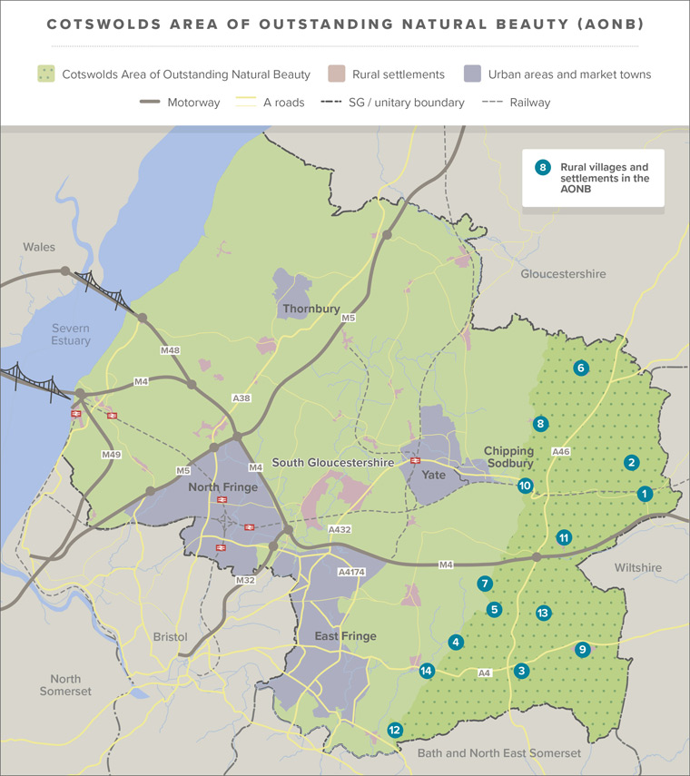
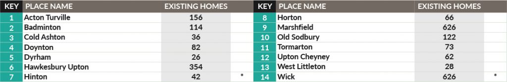
Cotswolds Area of Outstanding Natural Beauty (AONB)
The eastern side of South Gloucestershire is in the Cotswolds Area of Outstanding Natural Beauty (AONB), an area of national significance for landscape quality and beauty. National planning policy (National Planning Policy Framework, paragraph 172) recognises the importance of Areas of Outstanding Natural Beauty (AONB) and places great importance on conserving and enhancing their landscape and scenic beauty.
The Cotswolds AONB is shaped both by its geology and by human activity, including farming, which combine to create a unique, distinctive landscape. The built environment we see today reflects the evolution of farmsteads, hamlets and villages to market towns that developed as centres for trade over centuries. The Cotswolds contains a wealth of heritage assets, including scheduled ancient monuments, listed buildings, conservation areas and historic parks and gardens, and is widely regarded as being the quintessential pre-industrial English landscape.
The natural and cultural environment of the Cotswolds offers opportunities to enhance the physical and mental well-being of both local people and visitors from across South Gloucestershire and beyond, through a range of leisure activities, including walking, running, cycling and quiet relaxation. The importance of being able to access high-quality countryside like the Cotswolds AONB is well trailed, and has been further highlighted by the Covid-19 pandemic. We think it is important for communities to be well-connected by walking and cycling routes to the recreation and wellbeing opportunities offered by the AONB.
The Cotswolds has a varied economy, largely based around farming, forestry, tourism and quarrying, all of which continue to influence and contribute to the landscape. We think that, in future, the Cotswolds AONB may also offer significant opportunities to contribute to addressing some of our environmental and climate change priorities, including the provision of new areas for biodiversity offsetting, tree planting, natural flood alleviation, Green Infrastructure and nature connectivity, as well as potentially suitable areas for renewable energy generation.
The AONB is generally considered to be an affluent area, although there are pockets of social and economic deprivation, often as a result of limited public transport and lack of services in some areas, which can contribute to rural isolation. Added to this, the lack of new housing development can lead to high house prices in the AONB and a lack of Affordable Housing. This can mean that many people who grew up, and/or work, in the AONB, often cannot afford to remain living in the communities they grew up or work in. There are also issues in terms of the long-term sustainability of key services and facilities in local communities. The Cotswolds AONB is a living, working landscape and we want to explore possibilities to support the local economy, as well as any opportunities that positively contribute to meeting our objectives on climate change and nature recovery, including the potential to generate renewable energy, and new areas for wildlife, tree planting and green infrastructure corridors. The provision of a mixture of well-designed, mixed tenure and Affordable Housing can help to support existing communities to thrive and prosper.
We think that there is an opportunity for our new Local Plan to state more clearly, a strategy, for the communities and landscapes in the AONB. We think it is important to be clear about the relationship of these communities and spaces to the rest of South Gloucestershire and the vital part they could play in helping the whole of South Gloucestershire achieve its sustainability ambitions.
However, while investigating the potential for growth of homes, employment or other uses in the AONB, careful consideration will need to be given to the AONB and its setting, to avoid harmful effects. Regard will also be given to the Cotswolds AONB Management Plan, and the statutory purpose of the AONB designation, to conserve and enhance their natural beauty. We think this would be most effectively done when we consider individual places and proposed sites at village and settlement level.
Because of the issues mentioned above, we think it is appropriate to investigate the potential for the appropriate and sustainable growth of villages and settlements within the Cotswolds AONB.
Green Belt
National planning policy places great importance on Green Belts, which aim to prevent urban sprawl, by keeping land permanently open. As 42% of South Gloucestershire is designated as Green Belt, the approach to planning for growth in villages and settlements will recognise the important role of the Green Belt.
National planning policy requires us to demonstrate that we have looked at all reasonable options for meeting South Gloucestershire’s development needs before looking at changing the extent of the Green Belt. Our new Local Plan is already investigating ways to maximise the amount of new development that can be accommodated in the existing urban areas and on brownfield sites through the ‘Urban Lifestyles’ approach. We will need to consider non-Green Belt locations in our rural areas, before we can plan for growth in Green Belt locations. We also need to work with neighbouring authorities who have non-Green Belt land that could potentially be considered for development.
Although, we do not yet know what level of growth we will need to plan for, the Issues section has set out that meeting all growth needs in our existing urban areas will probably be very challenging and could have negative impacts on the quality of life and environment in those areas. We also know that adjoining local authorities also have their own housing needs to meet.
Therefore at this early stage, when we consider which rural communities should be investigated for some level of growth, in the context of the Green Belt, we think there are two broad options to consider:
- Only investigate the potential for an appropriate level of small to medium-scale growth in villages and settlements outside of the Green Belt
When preparing previous Local Plans, there has, traditionally, been support for protecting the existing area of Green Belt in South Gloucestershire. We also need to consider this option because national planning policy requires us to demonstrate that we have looked at all reasonable options for meeting our development needs before looking at any changes to the extent of the Green Belt.
- Investigate the potential for an appropriate level of small to medium-scale growth in villages and settlements both outside of and inside the Green Belt
This would result in the largest number of villages and settlements being considered, and providing the broadest range of possible options to deliver the homes needed for communities across South Gloucestershire.
A summary of the pros and cons of each of these options is provided for reference in Appendix 1.
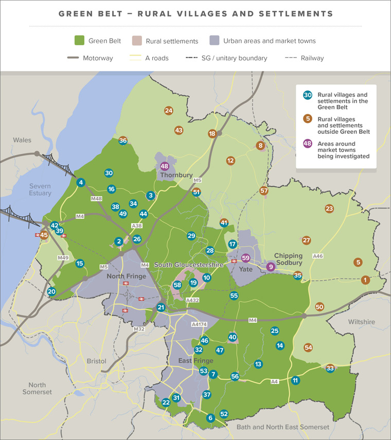
As part of this, it is also worth noting that a number of our villages and settlements are ‘washed over’ by the Green Belt, and others are ‘inset’ (cut out) in the Green Belt. This is another factor that may influence the approach we propose, in the context of the need to maintain the role and function of the Green Belt in those locations, in the next stage of preparing the Local Plan 2020.
Because of the amount of land in the Green Belt and covered by other key constraints, we think, based on work we’ve undertaken to date, that it is very likely we will need to look at options for growth in and around villages and settlements that are both outside and inside the Green Belt. Because of this, we think it is appropriate to investigate the potential for growth in villages and settlements in the Green Belt.
By investigating the potential for an appropriate level of growth in the largest range of villages and settlements (and therefore, in the future, potential sites) we can be more selective about how much growth and where growth is proposed in our new Local Plan. This will help us meet our emerging new Local Plan priorities; such as ensuring we place growth in locations where it is possible to walk, cycle and use public transport to access services and facilities. This approach can also avoid the potential overloading of villages and settlements outside the Green Belt that would harm our designated environment, heritage assets and unique character of many rural villages.
Other planning considerations and issues
There are other important considerations that we will need to take into account when we consider what might be an appropriate level of growth in our villages and settlements. Some of these have been highlighted in the guiding principles in section 5 of this document. These and others will need to be investigated at site level and include the need to:
- protect and enhance designated ecological assets – including internationally, nationally (including Sites of Scientific Interest (SSSIs)) and locally-protected sites (including Sites of Nature Conservation Interest (SNCIs))
- protect and enhance landscape and heritage designations and their settings – like key hillsides, valleys, ridgelines, conservation areas and listed buildings
- protect and enhance the function and connectivity of our emerging green infrastructure and nature recovery networks
- consider any potential for below ground-level issues including contamination, for example as a result of previous land uses
- ensure that we protect a ‘sense of place and character’ when planning for new development.
We can begin to think about these considerations in detail, when we begin to look at potential options in villages and settlements at a site level.
Consideration of these issues will be presented at the next stage of the Local Plan, once potential sites for development have been identified (through the Call for Sites) and assessed (through the HELAA and other technical work) and we are in a position to discuss potential options at a village and settlement level. The emerging outputs of this work will be presented in our Phase 2 consultation document, which we hope to publish in Autumn 2021.
Summary
At this stage of preparing the new Local Plan we think that unless there are significant constraints or sustainability issues, all of our rural villages and settlements should be considered, to determine the role they could play in our strategy for the sustainable growth of homes and jobs. We are looking at different considerations and approaches that we might use to determine potential and appropriate levels of growth in individual villages and settlements.
As part of this, we will look at the size of existing communities and recent and approved developments. We will also consider the level of existing and potential sustainable travel to key services and facilities and the potential positive impacts on small rural schools and school transport, as well as the role of digital connections and broadband.
- Are there any other key considerations you feel we should consider?
- Do you agree with our proposed approach to the national policy issues highlighted, like flood risk, the Cotswolds Area of Outstanding Natural Beauty, Green Belt, and other important planning designations?
- Are there any other issues you think we should consider? Please provide as much detail as you can to support your views.
What happens next?
Following this consultation, we will analyse and consider all the responses received, with the aim of understanding of what might be an appropriate level of growth in individual villages or settlements. The feedback we receive will assist in determining how we approach the next stage of preparing our new Local Plan.
At this stage we are particularly interested in understanding if there are other principles/ issues we should consider to establish what might be an appropriate level of growth in each community, and whether you agree with our approach to Flood Risk, the AONB and Green Belt.
Alongside this, we will also need to consider and assess the sites submitted to us through the Call for Sites 2020, by undertaking a Housing and Economic Land Availability Assessment (HELAA). This will consider growth at site level within individual rural communities. This will be key for understanding the impact on ecological, heritage, landscape and other key principles. Once this work has been concluded, we will be in a position to start to look at potential options at a site level within individual villages and settlements. The emerging outputs of this work will be presented through our Phase 2 consultation document which is anticipated in Autumn 2021.
It is also worth flagging that the government published a Planning White Paper for consultation in August 2020 which proposes significant changes to the planning system and national planning policy. The White Paper proposes include reforms to the way local plans are produced and what they should contain, which will impact on how we progress our new Local Plan in future years.
At this moment in time we cannot be certain as to what the exact changes to the planning system and new approaches to Local Plans will be. It is likely to affect the way we present and discuss future options and choices around growth and change. What is certain however, is that through our new Local Plan we will need to make choices around growth, change and protection in and around our rural communities.
Appendix 1: Summary of Green Belt options
National Planning Policy attaches great importance to Green Belts. The fundamental aim of the Green Belt is to prevent urban sprawl by keeping land permanently open. National Planning Policy requires all Local Plans to demonstrate that brownfield, urban and non-Green Belt land has been explored prior to proposing changes to the Green Belt.
With this in mind, there are two separate options we need to consider: investigating the potential for growth in those villages and settlements outside of the Green Belt; and, investigating the potential for growth in those villages and settlements both outside of and in the Green Belt. Doing so will help us to identify at this early stage, and at a high level, what the pros and cons might be of either approach.
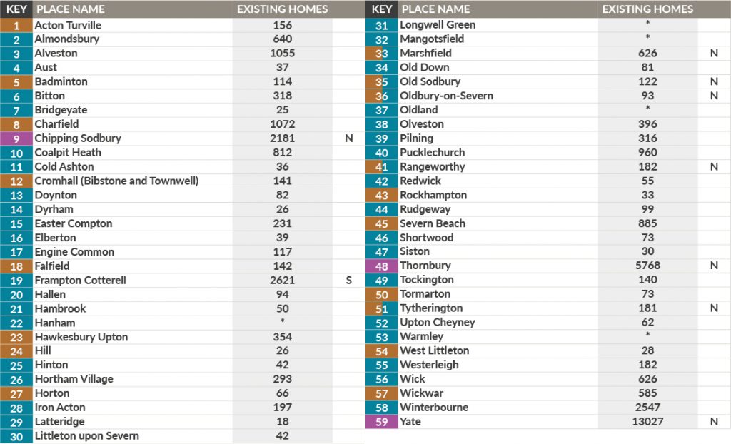
In order to do this, we have categorised our rural villages and settlements into places which are either outside (including areas partially outside) the Green Belt, or inside/ surrounded by Green Belt, to help us understand the two high level options:
- Investigate the potential for small to medium-scale growth in villages and settlements outside of the Green Belt; or
- Investigate the potential for small to medium-scale growth in villages and settlements both outside the Green Belt and in the Green Belt.
Please note that some villages/ settlements are included within both options, as part of them are within/ surrounded by the Green Belt and other parts are outside of the Green Belt. Examples of this include places such as Marshfield, Tytherington, Thornbury and Yate.
This appendix sets out our consideration of the potential positive and negative implications of these two options.
Option 1: Outside the Green Belt
Under this option the distribution of small and medium scale growth would be delivered on sites within and surrounding rural villages and settlements that are outside of the Green Belt.
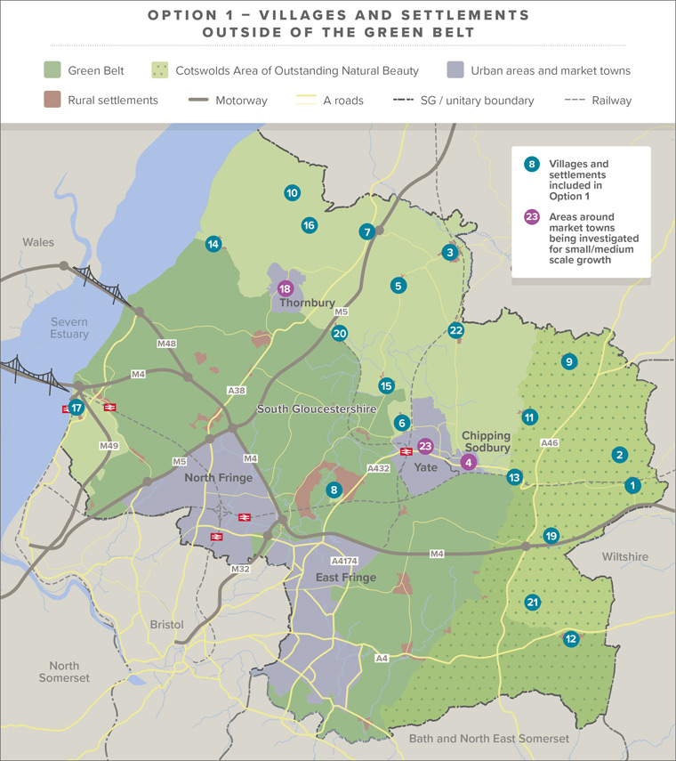
Positive
This option would safeguard the existing extent of the Green Belt in South Gloucestershire.
Certain settlements in this option, including Charfield, Chipping Sodbury, Coalpit Heath, Thornbury, Wickwar and Yate have walking and cycling access to a range of services and facilities and, or public transport connections (mostly below 30 minute journeys) to places containing facilities not within walking and cycling distance. On face value, development in these locations could reduce dependency on car journeys, as well as helping to avoid isolated rural dwellings, to create better connected and sustainable rural communities. However, the level of walking and cycling to key services and facilities, and public transport access varies across these settlements, with Yate for example, having far greater levels of sustainable access than Charfield and Wickwar. Further investigation of each of these villages/ settlements will be needed to inform any consideration of what might constitute an appropriate level of growth, and to avoid creating unsustainable patterns of development.
Neutral
Some of the villages and settlements in this option, such as Engine Common, Falfield, Hawkesbury Upton, Marshfield, Rangeworthy, Severn Beach and Tytherington have walking and cycling access to a limited number of services and facilities. Higher levels of development in these locations would be likely to be dependent on public transport, with most of the current services presenting a journey time of under 30 minutes, but with variations in journey length and number of destinations that can be connected to, which will need to be explored further. Reliance on rural public transport is considered to have a less positive impact on reducing car dependency than development in locations which also have walking and cycling access to a wider range of key services and facilities.
Negative/Uncertain
Some of the villages and settlements listed under this option have a low level of walking and cycling access to services and facilities, such as Horton and Old Sodbury. Cromhall also has a relatively low number of services accessible by walking and cycling, and longer public transport journeys of 30 and 45 minutes plus, with connections to a smaller range of destinations. In addition to this, there are some settlements under this option that do not currently have an appropriate minimum level of sustainable public transport links and very limited cycling and walking access to key services and facilities, which includes the following locations; Acton Turville, Badminton, Hill, Rockhampton, Tormarton and West Littleton.
The level of development considered for small and medium scale growth is unlikely to be of a scale sufficient to support major new public transport schemes or provision of new services and facilities (as opposed to supporting/ improving the viability of existing provision. Therefore, it is likely that development at some of these locations may be reliant on private car use to make the majority of journeys.
Further to this, several locations in this option are also in the Cotswolds Area of Outstanding Natural Beauty (AONB), including; Acton Turville, Badminton, Hawkesbury Upton, Horton, Marshfield, Old Sodbury and Tormarton. If development at these locations was minimised or avoided all together, there would be potential for increased pressure on the rest of the district including a smaller number of locations, where there are a range of other considerations to take into account, as set out below.
Finally, there are a number of different considerations to be taken into account at village/ settlement and site level to understand the potential effects of only proposing small to medium scale rural growth outside the Green Belt. This includes but is not limited to:
- Areas of high flood risk (Flood Zones 2 and 3) at the following settlements: Acton Turville, Badminton, Coalpit Heath, Charfield, Chipping Sodbury, Engine Common, Falfield, Hill, Rockhampton, Severn Beach, Thornbury, Wickwar and Yate.
- Sites of Special Scientific Interest (SSSIs) located either within or immediately adjacent to: Charfield, Chipping Sodbury, Severn Beach, Wickwar and Yate.
- Sites of Nature Conservation Interest (SNCIs) located either within or immediately adjacent to the majority of settlements included within this option, excluding: Cromhall, Falfield, Hill, Rockhampton and West Littleton and Wickwar.
- Conservation Areas, including: Acton Turville, Badminton, Chipping Sodbury, Hawkesbury Upton, Marshfield, Thornbury, Tormarton, Tytherington, West Littleton, Wickwar and Yate.
- Local Green Spaces (designated and nominated) within: Acton Turville, Charfield, Chipping Sodbury, Engine Common, Hawkesbury Upton, Marshfield, Thornbury, Rangeworthy, Rockhampton, Severn Beach, Tormarton, Tytherington, West Littleton, Wickwar and Yate.
- Scheduled ancient monuments (SAM) located within or immediately adjacent to Horton, Thornbury and Tytherington.
- Listed buildings are within each of the villages and settlements included in, apart from Engine Common and Severn Beach.
Taking these considerations together, as this option has a relatively small number of locations, the potential for harm or conflict with a wide range of important environmental, historic and natural environment considerations is considered to be high.
Option 2: Both inside and outside the greenbelt
Under this option, the distribution of small and medium scale growth would be delivered on sites that lie within or surround rural settlements that are either within or outside of the Green Belt.
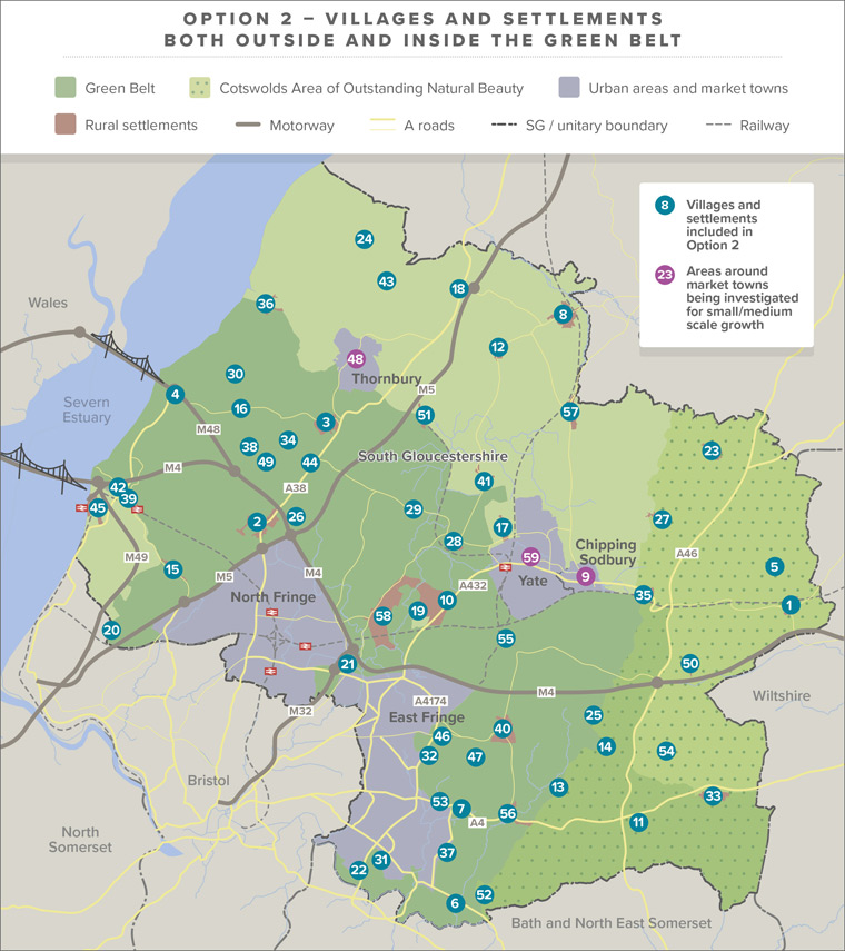

Positive
This option provides the highest number of potential villages/ settlements to deliver small and medium scale growth, creating the best opportunity to: provide a greater range of smaller sites across the district, ensure an appropriate, proportionate increase in existing settlement size, and avoid harm to any sensitive assets and local character.
In addition, this option also includes a higher number of villages and settlements with walking and cycling access to key services and facilities, some of them would still require public transport to avoid reliance on private car journeys. The public transport journey times, particularly in locations around Market Towns and the edge of the urban area are often relatively quick and connect to a wider range of destinations. These include: Almondsbury, Alveston, Chipping Sodbury, Coalpit Heath, Frampton Cotterell, Hambrook, Hanham UEL, Longwell Green UEL, Mangotsfield UEL, Oldland Common UEL, Pucklechurch, Shortwood, Thornbury, Warmley UEL, Winterbourne and Yate.
This option also includes the largest number of places outside of the AONB. While avoiding harm to the AONB would need to be investigated at village/ settlement and site level, investigating growth at a greater number of places will help to avoid pressure on AONB settlements outside of the Green Belt.
Neutral
Some of the villages and settlements included under this option, such as Bitton, Easter Compton, Falfield, Hawkesbury Upton, Hortham, Iron Acton, Marshfield, Rangeworthy, Redwick, Rudgeway, Severn Beach, Siston, Tytherington and Wick have walking and cycling access to a relatively limited number of services and facilities. Development in these locations would likely be dependent on rural public transport links and, although these mostly have a journey time under 30 minutes, some require a journey time over 30 and 40 minutes. Furthermore, some of these locations only have public transport connections to one larger destination. This is considered to have a less positive impact on reducing car dependency than places which also have walking and cycling access and faster public transport journeys with connections to a wider range of places.
Negative/Uncertain
This option would require the release of some areas of Green Belt in South Gloucestershire, particularly around the urban edge.
A number of the villages and settlements listed under this option have lower levels of walking and cycling access to services and facilities as well as longer public transport journey times and/or reduced numbers of destinations which can be reached. This is the case for Bridgeyate, Cold Ashton, Cromhall, Engine Common, Horton, Old Down, Old Sodbury, Olveston, Tockington and Westerleigh.
In addition to this, there are some villages and settlements under this option that currently have no appropriate minimum level of sustainable public transport links and very limited walking and cycling access to key services and facilities. Examples of this include: Acton Turville, Aust, Badminton, Doynton, Dyrham, Elberton, Hallen, Hill, Hinton, Latteridge, Littleton-Upon-Severn, Oldbury-On-Severn, Rockhampton, Tormarton, Upton Cheyney and West Littleton.
The level of development considered for small and medium scale growth is unlikely to be of scale sufficient to support major new public transport schemes or provision of new services and facilities (as opposed to supporting/ improving the viability of existing provision. Therefore, it is likely that development at some of the locations may be reliant on the private car to make the majority of journeys.
Additionally, the same issues highlighted for places in Option 1 will need consideration at site level to fully understand the potential impacts. However, in comparison to Option 1, Option 2 is considered to offer the greatest potential number of alternative villages and settlements to investigate for an appropriate level of growth. These considerations include but are not limited to:
- Areas of high flood risk (Flood Zones 2 and 3) at the following settlements: Acton Turville, Aust, Bitton, Badminton, Bridgeyate, Charfield, Chipping Sodbury, Doynton, Coalpit Heath, Easter Compton, Falfield, Engine Common, Frampton Cotterell, Hallen, Hambrook, Hill, Iron Acton, Littleton-Upon-Severn, Oldbury-On-Severn, Olveston, Pilning, Redwick, Rockhampton, Severn Beach, Thornbury, Warmley UEL, Wick, Wickwar, Winterbourne and Yate.
- Sites of Special Scientific Interest (SSSIs) are located either within or immediately adjacent to: Charfield, Chipping Sodbury, Cold Ashton, Hanham UEL, Redwick, Severn beach, Winterbourne and Yate.
- Sites of Nature Conservation Interest (SNCIs) are located either within or immediately adjacent to the majority of settlements outlined in this approach, excluding: Almondsbury, Cromhall, Doynton, Elberton, Falfield, Hill, Hinton, Hortham, Iron Acton, Latteridge, Littleton-Upon-Severn, Olveston, Pucklechurch, Rockhampton, Rudgeway, Tockington, Upton Cheyney, Westerleigh and West Littleton.
- Conservation Areas, including: Acton Turville, Almondsbury, Badminton, Bitton, Chipping Sodbury, Cold Ashton, Doynton, Dyrham, Hambrook, Hanham UEL, Hawkesbury Upton, Iron Acton, Marshfield, Olveston, Pucklechurch, Siston, Thornbury, Tockington, Tormarton, Tytherington, Upton Cheyney, West Littleton, Wickwar, Winterbourne and Yate.
- Local Green Spaces (designated and nominated) within: Acton Turville, Alveston, Bridgeyate, Charfield, Chipping Sodbury, Coalpit Heath, Engine Common, Hanham UEL, Hawkesbury Upton, Hinton, Iron Acton, Longwell Green UEL, Marshfield, Old Down, Oldland Common UEL, Olveston, Pilning, Pucklechurch, Rangeworthy, Rockhampton, Severn Beach, Shortwood, Thornbury, Tormarton, Tytherington, Westerleigh, West Littleton, Wick, Wickwar, Winterbourne and Yate.
- Scheduled ancient monuments (SAM) located within or immediately adjacent to Alveston, Bitton, Horton, Iron Acton, Oldbury-On-Severn, Olveston, Pucklechurch, Thornbury and Tytherington.
- Listed buildings are found within the majority of villages/ settlements included in this option
Questions and comments
To answer these questions visit our online consultation page at www.southglos.gov.uk/localplan2020-feedback to complete or download our questionnaire.
Read the next chapter – Planning policies.
Go back to the Local Plan 2020 – Phase 1 Issues and Approaches document landing page.