What we want to do
We want to discuss a new and updated Strategic Green Infrastructure (GI) Network, which would be safeguarded as part of the new Local Plan.
A linked strategic policy and other local policies would manage the approach to protect the integrity of the network but at the same time facilitating appropriate change and development.
What is a Strategic Green Infrastructure Network and Green Infrastructure (GI)?
Strategic Green Infrastructure when planned effectively can create a network of sustainable natural and semi natural landscapes and habitat areas, heritage features, walking and cycle routes, areas for recreation and leisure, green spaces, rivers and other water bodies. These intersperse, connecting villages, towns and urban areas within South Gloucestershire and link to adjoining areas.
At a more local level, community spaces, parks, village greens, orchards, churchyards, nature sites and local footpaths and cycle routes all compliment and link with the overarching strategic GI. When development and land changes respect the GI network and are coordinated to enhance it with connectivity and functions in mind, there can be wide ranging benefits for people, nature, adaptation to climate change, resilience to flood risk by suitable natural flood storage, improved visual amenity and the quality of places and development in South Gloucestershire.
Designation of a Strategic Green Infrastructure Network will assist in prioritising certain areas for future investment in biodiversity, secured through the emerging national and local requirements for ‘biodiversity net gain’. The investment in biodiversity and nature which will come forward through the net gain principle, when directed to locations in the newly designated Strategic Green Infrastructure corridors displayed in this chapter will assist with the creation of ‘Wild Belts’, places where nature and the natural environment can thrive.
The Strategic Green Infrastructure network can also act as a focus for implementing ‘natural capital solutions’, rewilding and taking proactive steps to increase the quality and connectivity of our natural habitats. within the network. The potential of a designated connected network to include areas identified for net gain, increasing tree planting and enhanced green corridors will also increase carbon sequestration and opportunities for carbon offsetting through enhancements to habitat, green corridors and new natural areas.
Therefore, when investigating locations for new growth within South Gloucestershire it is important to plan for both development of homes, jobs and infrastructure, as well as enhancement to green infrastructure, in a connected and co-ordinated way.
Our proposed strategic network contains sites and designations that are already protected from development through separate designations in the Local Plan, for example; SSSI, SNCI, Ancient Woodland, Conservation Areas, Registered Historic Parks and Gardens, Local Green Spaces, public rights of way. Other parts of the network are protected by legislation and planning system such as Common Land.
However, whilst other parts of the strategic GI network may not include designated sites or features, they perform an important function in terms of providing a mix of existing and potential connectivity between these areas, as well as offering opportunities for enhancement of the strategic network of woodlands, grasslands and wetlands. New and enhanced development proposals for homes, jobs, infrastructure and other uses may be acceptable in the Strategic Green Infrastructure Network; providing they respect the integrity of the network and maintain the function and connectivity of the section of the network they are in.
It is important to note that outside of the proposed strategic GI network, protection of nationally and locally designated sites and important green and blue GI assets such as the wider area of the Cotswold AONB (Cotswold National Landscape) will still exist. The strategic network identifies areas where connectivity and function are needed on a wider scale.
What we need to do
The starting point is to identify the land that forms part of this strategic GI network and set out the main corridors in this network.
The ‘Green Infrastructure Corridor Study Report Introduction and Methodology’ (2021) has informed consideration of the assets and areas which should form part of the Strategic GI Network.
You can read the methodology and more information about the GI corridors on our New Local Plan evidence base page, under ‘Green infrastructure – February 2022 update’.
Our proposed Strategic Network of GI corridors, which has built into its connections for habitats and wildlife and forms part of our emerging Local Nature Recovery Network, has also been informed by the published ‘West of England Joint Green Infrastructure Strategy’ (JGIS) June 2020.
The strategic GI network has also been informed by the West of England Local Nature Partnership (WENP) ecological (habitats) network mapping, which in turn responds to the recommendations contained in the ‘Making Space for Nature’.
The Strategic GI Network – Option
We want to share where in district we think the Strategic GI Network should be and the nine strategic corridors within the network.
The intention is that the strategic network will be defined on the policies map. And development within or near to it managed by new planning policies, strategies and plans for enhancing the GI corridors and assets within them.
Protection of designated and important GI assets lying outside the corridors will remain.
You can view our proposed Strategic Green Infrastructure Network and comment on our proposal to define it on our policies map, on our interactive map below.
You can click on the map, or use the link below the map to view and comment.
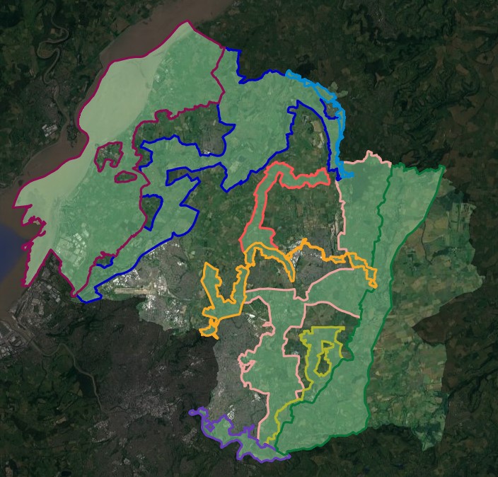
Nine Strategic Green Infrastructure Corridors
Each of the nine Green Infrastructure corridors that make up the network have unique functions and individual assets within them. Green assets for example primarily related to visually important hillside features and associated areas of strategic woodland and grassland habitat. Blue-green assets relate to the Severn estuary and Key River corridors and associated strategic wetland habitat network.
The corridor and nature of assets within will guide the approach to achieving positive connectivity and enhancement to their quality and function.
The individual corridors and summary of them is set out below.
Further detailed guidance and information on each corridor will be set out in the Strategic Green Infrastructure Corridor Mapping Project.
Shepperdine – Oldbury on Severn – Severn Beach (Severn Estuary and Levels)
Extends from SW to NE to follow the River Severn estuary to take in the marine, foreshore and adjacent Levels areas. Primary function and importance: focused on the strategic wetland network associated with the river corridor and related designated RAMSAR, Special Conservation Area, Special Protected Area and SSSI sites, and linked network of rhines and watercourses across the Levels.
Charfield – Alveston – Hallen (Western Scarp/ Severn Ridges)
Extends from SW to NE, before turning SE, along the ‘S shaped’ Severn Ridge that comprises a series interlinked scarps: Primary function and importance: strategic woodland network associated with a Visually Important Hillside/ridge landform features, although the existing woodland network does not currently extend along the most easterly section.
Winterbourne – Kendleshire – Yate (River Frome Corridor)
Extends from S to N and NE and eastwards along the River Frome corridor, with a north westerly fork along the Bradley Brook corridor. Primary function and importance: strategic wetland network associated with both river corridors, with that of the River Frome penetrating the urban areas of yate and Winterbourne through which it passes, and also takes in part of the strategic woodland network at its western end.
Wickwar – Westerleigh – Bitton (Westerleigh Vale Oldland Ridge/ East Fringe)
Extends from S to N along the Oldland Ridge and Westerleigh Vale to link with the Pucklechurch Ridge, and further north takes in the Wickwar Vale.
Primary function and importance: a mosaic of strategic woodland and grassland habitat associated with the Visually Important Hillside/ridge landform features within its southern part, and taking in the strategic grassland network principally associated with common land in its central part, and strategic woodland network within its northern part including the Lower Woods SSSI and Wetmoor.
Hawkesbury – Old Sodbury – Upton Cheney (Cotswold Scarp)
Extends from S to N to take in the westerly facing scarp of the Cotswold National Landscape. Primary function and importance: a mosaic of strategic woodland and grassland habitat associated with the Visually Important Hillside feature of the Cotswold Scarp. Corridor also takes in a number of historic parks and gardens associated with large estates.
Hanham Green – Hannah Abbots – Bitton (Avon Valley)
Extends from NW to SE along SW facing valley side of the River Avon. Primary function and importance: strategic woodland network associated with a Visually Important Hillside/landform feature.
Wickwar – Iron Acton – Yate (Ladden Valley)
Extends from S to NE along the Ladden Brook valley. Primary function and importance: strategic wetland network associated with the brook.
Hinton – Doynton – Bitton (Boyd Valley)
Extends from S to N along the River Boyd valley to the east and the Feltham Brook to the west. Primary function and importance: a mosaic of strategic wetland and woodland habitats associated with the length of both river corridors.
Huntingford – Charfield – Wickwar (Little Avon River Corridor)
Extends from S to NW along the Little Avon valley. Primary function and importance: strategic wetland network associated with the river, which also takes in part of the strategic woodland network at both its southern and northern ends.
Linked planning policy, future strategy and projects
In the policies section of this document there is a draft Green Infrastructure policy which sets out how development in the strategic network will be managed. This policy will eventually replace adopted policy CS2.
Within the strategic GI network some land will continue to be protected from development through separate designations and policies in the Local Plan e.g. SSSI (currently policy PSP18), SNCI (currently policy PSP19), Ancient Woodland (current policy PSP3), Local Green Spaces (currently policy PSP4), public rights of way or protected by other legislation such as Common Land.
In the remainder of the network there will be a need to maintain functional connectivity, through the placement and design of new homes, jobs and infrastructure, and through those developments providing new GI assets such as wildlife corridors, open spaces, trees, playing pitches, woodland, grassland and wetland.
In addition to planning policies and designations new strategies and enhancement projects are being developed to improve land, connections and quality of the network and assist the creation of Wild Belts in South Gloucestershire.
Emerging projects and schemes include:
- Commons Connection Project – Corridor D
- River Frome Reconnected – Corridor C and G
- String of Pearls – Corridor A
- The South Gloucestershire Green Infrastructure Strategy, which sets out a variety of actions both strategic and local that are looking to enhance places both in and outside the strategic GI network.
Question
Do you agree that the Strategic Green Infrastructure Network, which consists of the nine corridors shown on the map, should be designated in our new Local Plan?
To answer this question please use our online questionnaire.
Read the next chapter – Phase 2 planning policies
Go back to the Local Plan 2020 – Phase 2 Urban, Rural and Key Issues document landing page.