Local Plan 2020 Phase 1 consultation
Setting the scene – South Gloucestershire today
This section gives a summary of the authority with key facts and figures which provide the context for our new Local Plan’s key issues and priorities.
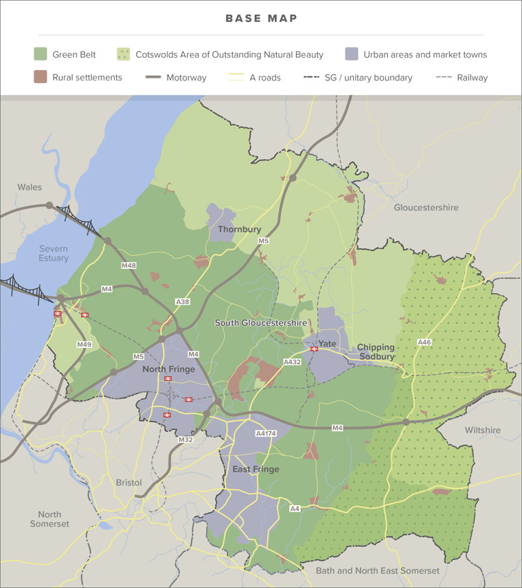
South Gloucestershire lies immediately to the north and east of the City of Bristol and is part of the West of England Combined Authority area .
The West of England Combined Authority (WECA) is made up of three of the councils in the region – Bath & North East Somerset, Bristol City and South Gloucestershire.
The area has close links with Bristol but some communities in the north and east of the authority also have functional links with places in Gloucestershire, Wiltshire, Bath & North East Somerset and into south Wales.
Population and housing
South Gloucestershire has a population of 282,600 (based on 2018 mid-year estimate). Around 63% of the population live in the suburban areas to the north and east of Bristol, 17% in the market towns of Yate, Chipping Sodbury and Thornbury. The remaining 20% live in the villages and rural areas of the authority.
South Gloucestershire is an attractive area which has successfully attracted and sustained investment and growth. There has been substantial population increase over the past half century with an increase of 33,500 people over the last 15 years (based on 2018 mid-year estimate).
Like many other places South Gloucestershire has an ageing population, with an increasing number of older residents (pdf) who have associated needs in terms of access to appropriate housing and services.
The Core Strategy looked to support sustainable growth by planning for significant numbers of new homes, jobs, supporting facilities and infrastructure on the former Filton Airfield and on greenfield land next to the urban area at Harry Stoke and Emersons Green, as well as significant growth at the market town of Yate and a small level of growth at Thornbury. These developments were planned in addition to the continued focus of redeveloping brownfield land in the North and East Fringes of Bristol’s urban area which stretches from Cribbs Causeway in the north-west to Hanham in the south-east. There has been a considerable level of growth since adoption of the Core Strategy in many of these identified areas, however, some large-scale sites began developing later than expected, and others are not yet completed.
Planned development in rural areas has been based on infilling within existing village boundaries, with an opportunity to meet any additional identified local needs through rural exception sites and neighbourhood plans.
However, in recent years, there has been an increase in speculative development in market towns and villages which are outside the Green Belt. This means some larger developments have come forward on sites which were not allocated for development in the Core Strategy.
South Gloucestershire is a relatively affluent area with above average levels of employment and health overall. However, evidence shows that the inequalities gap between the most and least deprived residents has increased in seventeen out of twenty-five health indicators. This means that many people in our communities have reduced opportunities for good economic, physical and mental health and well-being. A new strategic and holistic approach to tackling inequality in our authority has been adopted and is recognised in the emerging Council Plan.
Local economy, retail and tourism
The area has benefited from a prosperous, innovative and diverse economy. Our GDP in 2018 was £12,865M, ranking us 20th of all local authorities in England and 11th outside of London. The proportion of the population in employment in South Gloucestershire (82.7%) is higher than the national average (75.9% – Annual Population Survey 18/19, ONS), which reflects the strong economy of South Gloucestershire and more widely the West of England. However, some parts of our area have relatively low levels of access to job opportunities. In addition, the impacts of Covid19 on the national and local economy are challenging to predict but may have significant impacts on major employers and future economic investment in the area.
The majority of South Gloucestershire’s residents work within the service sector (around 80% of working residents). There are several key employers in the authority providing manufacturing and advanced engineering roles, with major employers like Airbus UK, GKN Aerospace and Rolls Royce specialising in advanced research and development. The University of West of England (UWE) and the Bristol and Bath Science Park provide a world class environment for businesses in science and advanced technology.
South Gloucestershire has three designated Enterprise Areas; Emersons Green, Filton and Severnside, which provide employment and training opportunities across a variety of sectors and make a significant contribution to the West of England economy. In total 1266Ha of land is safeguarded in the Core Strategy for employment purposes (Policy CS12) on land both in and outside the Enterprise Areas. The Core Strategy also seeks to protect employment uses outside of safeguarded employment areas (Policy CS13).
There are a range of designated town centres, as well as local high streets across our authority, which provide shopping, community and leisure facilities, as well as employment opportunities. In addition, the Mall at Cribbs Causeway has the largest concentration of shopping and leisure facilities in one location. There are also a number of retail parks, the most significant are located at Longwell Green in the East Fringe, and adjacent to the Mall at Cribbs Causeway.
South Gloucestershire has an emerging profile as a cultural and tourist destination, with traditional attractions such as the National Trust’s Dyrham Park and the Cotswold Way national trail and more recently developed attractions including the Aerospace Bristol Museum, Bristol Zoo’s Wild Place and The Wave surfing lake. Planning permission has been approved for a significant new leisure and entertainment facility adjacent to the former Filton Airfield, a new arena and events space to serve the wider sub-region.
Infrastructure and services
The substantial levels of new development and change over the past half century have not always been fully matched by the timely provision of essential infrastructure such as public transport, education, health, retail, open space and community facilities. Consequently access to some services and facilities is poorer in some communities than others. However, there has been significant investment in infrastructure since the Core Strategy was adopted. This includes the ongoing expansion of the Metro Bus service connecting the Science Park, the North Fringe and Cribbs Causeway to Bristol city centre and Hengrove. There have also been recent improvements to bus services to Yate and Thornbury from Bristol.
Travel and accessibility
South Gloucestershire has very good strategic road and motorway links including the M4, M5 and the M32 leading to/ from central Bristol. Mainline railways also provide strategic links to the north, south, east and west. The strategic transport network is complemented by local rail services and a local network of bus services.
The authority has an evolving strategic cycling network, with significant stretches of dedicated cycle lanes, connecting key destinations around the North and East Fringes of Bristol and connections to Bath and Bristol City Centres via the National Cycle Network. There is an extensive network of public rights of way throughout the urban and rural areas. However, the opportunity to access key services, facilities and job opportunities by walking, cycling and public transport varies significantly across both urban and rural areas. Our cycling and walking networks are still fragmented in places and affected by barriers to movement such as major road and rail corridors. Transport schemes and policy are developed in partnership with WECA, neighbouring local authorities and delivery partners through the Joint Local Transport Plan. Transport investment has resulted in increases in the levels of walking, cycling and public transport use across the West of England sub-region. However, transport and private car use is a significant contributor to climate change. Car ownership and the number of people that commute by car remains high in South Gloucestershire, adding to congestion on parts of the strategic and local road network in peak periods.
Due to traffic pollution, air quality problems have been identified in parts of Staple Hill and at Kingswood to Warmley. As a result, these areas have been declared Air Quality Management Areas (AQMAs).
Climate change
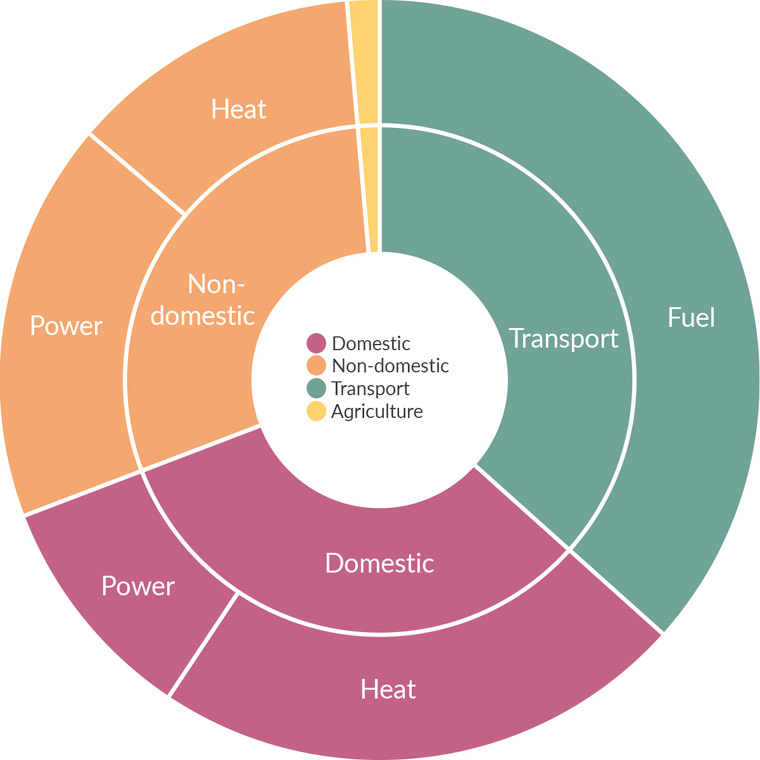
South Gloucestershire Council declared a Climate Emergency on 17 July 2019. The overarching target is for South Gloucestershire to be carbon neutral by 2030. Scientific research indicates that climate change is occurring as a direct result of global warming, largely due to increases in greenhouse gasses caused by human actions. Energy consumption by businesses, homes and road transport are the primary contributors to these emissions. South Gloucestershire contributes slightly higher greenhouse gas emissions than the UK average per year, and significantly higher than the South West average.
The main sources of carbon emissions in South Gloucestershire
Environment
South Gloucestershire has a rich and varied natural and built environment. The Cotswolds Area of Outstanding Natural Beauty covers 11,800ha (22%) in the east of the authority and includes a number of villages and settlements. Landscape ridges, hillsides and views frame the urban area and provide the setting for rural villages and settlements. Trees and woodlands currently cover approximately 11% of South Gloucestershire.
Within South Gloucestershire there are areas at high risk of flooding, in particular an extensive area along the low-lying landscape of the Severn Estuary.
Our area also contains a high number of internationally, nationally and locally designated nature conservation sites:
- the Severn Estuary is designated as a Special Area of Conservation (SAC) Special Protection Area (SPA) and Ramsar site due to its international importance for wildlife
- 22 nationally important Sites of Special Scientific Interest (SSSI), with the most significant concentrations found near Cold Ashton and Wickwar. The Severn Estuary comprises the largest SSSI
- 271 locally designated Sites of Nature Conservation Interest (SNCIs) and 64 Regionally Important Geological Sites (RIGS) which together form a network of what are known as Local Sites
- 10 Local Nature Reserves
- 75 registered commons covering 1.17% of the area; and
- a diverse range of nationally and internationally important wildlife species, including bats, dormouse, great crested newts, otters and water voles
However, our wildlife habitats are under considerable pressure and are, in places, fragmented and disconnected.
Relics of historic settlements and the industrial past texture the landscape. These historic buildings, settlements, parks and gardens, and archaeological features make an important contribution to the character of the area and many are designated for protection in the planning system.
There are:
- 30 conservation areas
- 2,085 listed buildings and 1,470 locally listed buildings
- 38 scheduled ancient monuments; and
- 8 registered parks and gardens
Over 40% of South Gloucestershire is covered by the Green Belt which surrounds and separates Bristol and Bath.
Read the next chapter – Issues and priorities
Go back to the Local Plan 2020 – Phase 1 Issues and Approaches document landing page.